TopoQuest Logo
Do you find TopoQuest useful?
Help keep TopoQuest running and adding new maps/features by donating!
Bitcoin:  19c7KJd3qBynnjoSw5npx9KScwjBe4ifkT
Litecoin:  LXs6TkuXGGXo1vDsWCkWVdjQX94eUKd6ui
Home View Maps Find Maps Find Places Resources & Links


Mount Pittsburg, Colorado Topographic Map

USGS Map Title: Mount Pittsburg, CO
USGS Map MRC: 38104E8
DRG (GeoTIFF) Download: o38104e8.tif


Neighboring USGS Topographic Map Quads:


  Big Bull Mountain, CO  
38105F1
 

  Mount Big Chief, CO  
38104F8
 

  Cheyenne Mountain, CO  
38104F7
 

  Phantom Canyon, CO  
38105E1
 

  Mount Pittsburg, CO  
38104E8
 

  Timber Mountain, CO  
38104E7
 

  Florence, CO  
38105D1
 

  Pierce Gulch, CO  
38104D8
 

  Stone City, CO  
38104D7


Map MRC Location:

N39°
W105°
N39°
W104°
H8 H7 H6 H5 H4 H3 H2 H1
G8 G7 G6 G5 G4 G3 G2 G1
F8 F7 F6 F5 F4 F3 F2 F1
E8 E7 E6 E5 E4 E3 E2 E1
D8 D7 D6 D5 D4 D3 D2 D1
C8 C7 C6 C5 C4 C3 C2 C1
B8 B7 B6 B5 B4 B3 B2 B1
A8 A7 A6 A5 A4 A3 A2 A1
N38°
W105°
N38°
W104°

Mount Pittsburg, CO USGS 1:24K Topographic Map Preview:
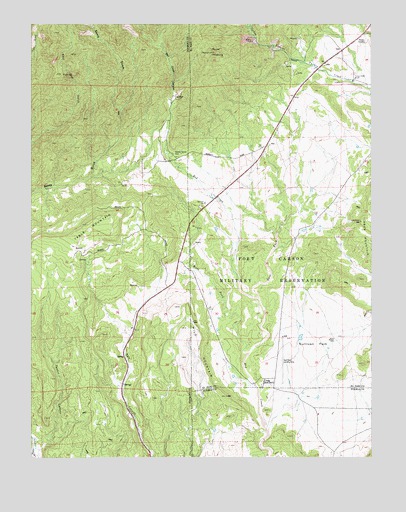
Mount Pittsburg, CO USGS Topographic Map
Click on map above to begin viewing in our Map Viewer.

This topographic map contains these locations and features:
Feature Name Type Latitude Longitude GNIS ID View Map
Booth Gulch PitMineN38.5269°W104.8766°1734092View Map
East Fork Red CreekStreamN38.5461°W104.9172°193639View Map
East Mill GulchValleyN38.5910°W104.9998°193634View Map
Ford Ranch QuarryMineN38.6083°W104.9589°1734088View Map
Fords Mountaindale RanchLocaleN38.6022°W104.9480°193636View Map
Fort Carson Fire and Emergency Services Station 34BuildingN38.6088°W104.8833°2667316View Map
Mount PittsburgSummitN38.6169°W104.9350°193635View Map
Patton CanyonValleyN38.5023°W104.9981°193645View Map
Pinehurst RanchLocaleN38.5817°W104.9422°193638View Map
Pinehurst Ranch (historical)LocaleN38.5817°W104.9422°1962126View Map
Red Creek CanyonValleyN38.5879°W104.9512°193573View Map
Red Creek RanchLocaleN38.5214°W104.9155°193641View Map
Salt Creek MineMineN38.5417°W104.9672°1734089View Map
Southwest Highway 115 Fire Protection DistrictBuildingN38.6037°W104.9050°2667265View Map
Strobel DitchCanalN38.6107°W104.8866°2724279View Map
Sullivan ParkFlatN38.5317°W104.8961°193642View Map
Table MountainSummitN38.5672°W104.9803°203538View Map
Timber MountainSummitN38.5681°W104.8791°203686View Map
Turkey CanyonValleyN38.6152°W104.9056°193575View Map
Turkey Creek RanchLocaleN38.6094°W104.8822°193637View Map
West Fork Red CreekStreamN38.5300°W104.9205°193640View Map
Wild MountainSummitN38.5433°W104.9478°193643View Map

Note: Coordinates in the location and feature list above are referenced to NAD83 datum.


Copyright (C) 2008-2024 Ryan Niemi / Sunset Dynamics ... All Rights Reserved