TopoQuest Logo
Do you find TopoQuest useful?
Help keep TopoQuest running and adding new maps/features by donating!
Bitcoin:  19c7KJd3qBynnjoSw5npx9KScwjBe4ifkT
Litecoin:  LXs6TkuXGGXo1vDsWCkWVdjQX94eUKd6ui
Home View Maps Find Maps Find Places Resources & Links


Mount Constitution, Washington Topographic Map

USGS Map Title: Mount Constitution, WA
USGS Map MRC: 48122F7
DRG (GeoTIFF) Download: o48122f7.tif


Neighboring USGS Topographic Map Quads:


  Sucia Island, WA  
48122G8


  Lummi Bay, WA  
48122G6
 

  Eastsound, WA  
48122F8
 

  Mount Constitution, WA  
48122F7
 

  Lummi Island, WA  
48122F6
 

  Shaw Island, WA  
48122E8
 

  Blakely Island, WA  
48122E7
 

  Cypress Island, WA  
48122E6


Map MRC Location:

N49°
W123°
N49°
W122°
H8 H7 H6 H5 H4 H3 H2 H1
G8 G7 G6 G5 G4 G3 G2 G1
F8 F7 F6 F5 F4 F3 F2 F1
E8 E7 E6 E5 E4 E3 E2 E1
D8 D7 D6 D5 D4 D3 D2 D1
C8 C7 C6 C5 C4 C3 C2 C1
B8 B7 B6 B5 B4 B3 B2 B1
A8 A7 A6 A5 A4 A3 A2 A1
N48°
W123°
N48°
W122°

Mount Constitution, WA USGS 1:24K Topographic Map Preview:
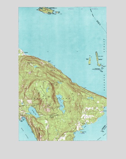
Mount Constitution, WA USGS Topographic Map
Click on map above to begin viewing in our Map Viewer.

This topographic map contains these locations and features:
Feature Name Type Latitude Longitude GNIS ID View Map
Barnes IslandIslandN48.7004°W122.7752°1503179View Map
Boyd Lower ReservoirReservoirN48.6310°W122.8204°1532998View Map
Boyd Lower Reservoir DamDamN48.6315°W122.8196°1532997View Map
Boyd Middle ReservoirReservoirN48.6347°W122.8229°1532996View Map
Boyd Middle Reservoir DamDamN48.6348°W122.8230°1532995View Map
Buck MountainSummitN48.6982°W122.8630°1503604View Map
BuckhornPopulated PlaceN48.7065°W122.8694°1510845View Map
Cascade BayBayN48.6457°W122.8688°1503836View Map
Cascade FallsFallsN48.6464°W122.8324°1503838View Map
Cascade LakeReservoirN48.6516°W122.8556°1513903View Map
Cascade Lake DamDamN48.6498°W122.8663°1532284View Map
Cavern FallsFallsN48.6484°W122.8292°1503866View Map
Chin-Chin-Tse-TungBeachN48.6343°W122.8574°1531374View Map
Clark IslandIslandN48.7015°W122.7643°1503992View Map
Clark Island State ParkParkN48.7015°W122.7643°1513906View Map
Cold CreekStreamN48.6551°W122.8530°1513270View Map
Cold SpringSpringN48.6663°W122.8395°1504064View Map
Day LakeLakeN48.6942°W122.8522°1504354View Map
Doe BayPopulated PlaceN48.6412°W122.7810°1511639View Map
Doe BayBayN48.6382°W122.7832°1504496View Map
Doe IslandIslandN48.6329°W122.7874°1504497View Map
Doe Island Marine State ParkParkN48.6329°W122.7874°1513916View Map
Eagle PointCapeN48.7473°W122.8482°1504619View Map
Entrance MountainSummitN48.6298°W122.8457°1504764View Map
False SummitSummitN48.6659°W122.8330°1512200View Map
Flahertys PondLakeN48.6595°W122.8712°1504923View Map
Hidden FallsFallsN48.6483°W122.8227°1505490View Map
Hidden RidgeRidgeN48.6676°W122.8463°1505493View Map
KAFE-FM (Bellingham)TowerN48.6798°W122.8413°1534514View Map
Kangaroo PointCapeN48.6504°W122.7549°1531377View Map
KBCB-TV (Bellingham)TowerN48.6798°W122.8410°1534551View Map
KISM-FM (Bellingham)TowerN48.6798°W122.8413°1534515View Map
KLYN-FM (Lynden)TowerN48.6790°W122.8432°1534528View Map
KVOS-TV (Bellingham)TowerN48.6776°W122.8313°1534552View Map
Little SisterIslandN48.6898°W122.7596°1506227View Map
Little SummitSummitN48.6582°W122.8341°1512397View Map
Lone Tree IslandIslandN48.6946°W122.7571°1506269View Map
Matia IslandIslandN48.7468°W122.8377°1506510View Map
Matia Island State ParkParkN48.7471°W122.8377°1506511View Map
Moran CreekStreamN48.6559°W122.8555°1533551View Map
Moran State ParkParkN48.6565°W122.8177°1508703View Map
Mount ConstitutionSummitN48.6776°W122.8310°1514785View Map
Mount PickettSummitN48.6668°W122.7999°1512558View Map
Mountain LakeLakeN48.6601°W122.8163°1513469View Map
Mountain Lake DamDamN48.6498°W122.8130°1532282View Map
Olga - Doe Bay CemeteryCemeteryN48.6268°W122.8245°1507165View Map
Paul CreekStreamN48.6495°W122.8260°1507333View Map
Peapod RocksIslandN48.6359°W122.7527°1507345View Map
Puffin IslandIslandN48.7446°W122.8213°1507649View Map
Raccoon PointSummitN48.6979°W122.8330°1512591View Map
Rolfe CapeCapeN48.7487°W122.8449°1507900View Map
Rolfe CoveBayN48.7484°W122.8430°1510444View Map
Rosario PointCapeN48.6440°W122.8735°1507914View Map
Rosario Resort MarinaLocaleN48.6464°W122.8717°2610329View Map
Rosario Seaplane BaseAirportN48.6457°W122.8680°1533931View Map
Rustic FallsFallsN48.6471°W122.8316°1507967View Map
San Juan County Fire District 2 / Orcas Island Fire and Rescue Station 23 RosarioBuildingN48.6546°W122.8656°2643928View Map
San Juan County Fire District 2 / Orcas Island Fire and Rescue Station 27 - Doe BayBuildingN48.6455°W122.7811°2643932View Map
San Juan Islands National Wildlife RefugeParkN48.7464°W122.8369°2765493View Map
San Juan WildernessReserveN48.7464°W122.8369°1531831View Map
Sea AcrePopulated PlaceN48.6523°W122.7568°1531908View Map
South PeapodIslandN48.6337°W122.7588°1508560View Map
Summit LakeLakeN48.6726°W122.8353°1508814View Map
The SistersIslandN48.6912°W122.7593°1508976View Map
Twin LakesLakeN48.6787°W122.8174°1509151View Map
Utter DamDamN48.6632°W122.7730°1532101View Map

Note: Coordinates in the location and feature list above are referenced to NAD83 datum.


Copyright (C) 2008-2024 Ryan Niemi / Sunset Dynamics ... All Rights Reserved