TopoQuest Logo
Do you find TopoQuest useful?
Help keep TopoQuest running and adding new maps/features by donating!
Bitcoin:  19c7KJd3qBynnjoSw5npx9KScwjBe4ifkT
Litecoin:  LXs6TkuXGGXo1vDsWCkWVdjQX94eUKd6ui
Home View Maps Find Maps Find Places Resources & Links


Moulton, Alabama Topographic Map

USGS Map Title: Moulton, AL
USGS Map MRC: 34087D3
DRG (GeoTIFF) Download: o34087d3.tif


Neighboring USGS Topographic Map Quads:


  Hatton, AL  
34087E4
 

  Masterson Mill, AL  
34087E3
 

  Caddo, AL  
34087E2
 

  Landersville, AL  
34087D4
 

  Moulton, AL  
34087D3
 

  Oakville, AL  
34087D2
 

  Bee Branch, AL  
34087C4
 

  Grayson, AL  
34087C3
 

  Upshaw, AL  
34087C2


Map MRC Location:

N35°
W88°
N35°
W87°
H8 H7 H6 H5 H4 H3 H2 H1
G8 G7 G6 G5 G4 G3 G2 G1
F8 F7 F6 F5 F4 F3 F2 F1
E8 E7 E6 E5 E4 E3 E2 E1
D8 D7 D6 D5 D4 D3 D2 D1
C8 C7 C6 C5 C4 C3 C2 C1
B8 B7 B6 B5 B4 B3 B2 B1
A8 A7 A6 A5 A4 A3 A2 A1
N34°
W88°
N34°
W87°

Moulton, AL USGS 1:24K Topographic Map Preview:
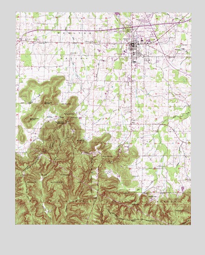
Moulton, AL USGS Topographic Map
Click on map above to begin viewing in our Map Viewer.

This topographic map contains these locations and features:
Feature Name Type Latitude Longitude GNIS ID View Map
Almon BranchStreamN34.4882°W87.3000°159063View Map
Almon CemeteryCemeteryN34.4720°W87.3161°159064View Map
Bera School (historical)SchoolN34.4818°W87.3595°163179View Map
Beulah ChurchChurchN34.3765°W87.2620°159170View Map
Bill Stewart Activity CenterSchoolN34.4723°W87.2800°169334View Map
Blowing SpringsSpringN34.3873°W87.2897°159204View Map
Bogar CemeteryCemeteryN34.4037°W87.2914°159222View Map
Brown School (historical)SchoolN34.4457°W87.3242°163180View Map
Buzzard Roost MountainSummitN34.4365°W87.3664°159289View Map
Cantrell CoveValleyN34.4462°W87.3678°159322View Map
Cheatham CemeteryCemeteryN34.4095°W87.2689°159378View Map
Cheatham KnobSummitN34.4151°W87.3145°159380View Map
City of MoultonCivilN34.4844°W87.2831°2404314View Map
Community Bible ChurchChurchN34.4820°W87.3603°161815View Map
Cowen MountainSummitN34.4526°W87.3670°163182View Map
Deer Run Golf CourseLocaleN34.4282°W87.3179°161818View Map
Delashaw School (historical)SchoolN34.4048°W87.2850°163183View Map
East Side Shopping CenterLocaleN34.4820°W87.2747°161819View Map
Elam ChurchChurchN34.4082°W87.2747°163184View Map
First United Methodist ChurchChurchN34.4823°W87.2928°161824View Map
Gibson CemeteryCemeteryN34.4356°W87.3045°159662View Map
Goodlett PoolsLakeN34.4909°W87.3022°163186View Map
Greg's Ambulance ServiceBuildingN34.4935°W87.2759°2674084View Map
Heflin CemeteryCemeteryN34.4823°W87.3203°159748View Map
Hickory Flat MountainSummitN34.4462°W87.3553°159762View Map
Irving PondLakeN34.4780°W87.2576°159851View Map
Lawrence County Christian SchoolSchoolN34.4829°W87.3597°161832View Map
Lawrence County CourthouseBuildingN34.4812°W87.2917°161833View Map
Lawrence County Emergency Medical ServicesBuildingN34.4821°W87.2829°2674085View Map
Lawrence County High SchoolSchoolN34.4759°W87.2997°159916View Map
Lawrence Medical CenterHospitalN34.4833°W87.2855°161834View Map
Leola (historical)LocaleN34.3918°W87.3172°161835View Map
McDonald CemeteryCemeteryN34.4895°W87.2975°160070View Map
Milam CemeteryCemeteryN34.4823°W87.2706°160093View Map
Montgomery CemeteryCemeteryN34.4440°W87.2945°160125View Map
MoultonPopulated PlaceN34.4812°W87.2934°160141View Map
Moulton Baptist ChurchChurchN34.4801°W87.2892°161840View Map
Moulton Church of ChristChurchN34.4790°W87.2917°161841View Map
Moulton DivisionCivilN34.4318°W87.2944°165842View Map
Moulton Elementary SchoolSchoolN34.4765°W87.2911°161842View Map
Moulton Fire DepartmentBuildingN34.4825°W87.2886°2683001View Map
Moulton Middle SchoolSchoolN34.4757°W87.2911°161843View Map
Moulton Municipal CemeteryCemeteryN34.4959°W87.2861°160142View Map
Moulton Police DepartmentBuildingN34.4814°W87.2939°2751997View Map
Moulton Post OfficePost OfficeN34.4821°W87.2863°166627View Map
Moulton ValleyValleyN34.4818°W87.3020°160143View Map
Mountain Spring School (historical)SchoolN34.3843°W87.3647°163190View Map
Mountain View School (historical)SchoolN34.3907°W87.3172°161846View Map
Muck CityPopulated PlaceN34.4826°W87.3547°160196View Map
Mulligan GapGapN34.3918°W87.2806°160204View Map
Muxy City School (historical)SchoolN34.4820°W87.3617°161847View Map
Penitentiary GapGapN34.4404°W87.3411°160356View Map
Penitentiary MountainSummitN34.4357°W87.3384°160357View Map
PinhookPopulated PlaceN34.4015°W87.2503°161853View Map
Pinhook BranchStreamN34.4407°W87.2522°160390View Map
Pinhook ChurchChurchN34.4015°W87.2500°160391View Map
Pinhook GapGapN34.3834°W87.2614°160392View Map
Pinhook School (historical)SchoolN34.4562°W87.2656°163192View Map
Pinhook School (historical)SchoolN34.4007°W87.2506°163193View Map
Pleasant Grove ChurchChurchN34.4373°W87.2928°160404View Map
Pleasant Ridge ChurchChurchN34.4762°W87.3375°160417View Map
Priest PondLakeN34.4810°W87.2573°160448View Map
Roberts CemeteryCemeteryN34.4309°W87.2925°160496View Map
Sledge CreekStreamN34.4893°W87.3403°160621View Map
Srygley BranchStreamN34.4893°W87.3389°163196View Map
Srygley MountainSummitN34.4590°W87.3461°163197View Map
Suttons GapGapN34.4190°W87.3514°161865View Map
Town SpringSpringN34.4779°W87.2945°164257View Map
Union ChapelChurchN34.4934°W87.3567°160772View Map
Warren SpringsSpringN34.4248°W87.3267°160802View Map
WFIQ-TVTowerN34.4320°W87.3445°163922View Map
WHIY-AM (Moulton)TowerN34.4820°W87.3011°161075View Map
WrenPopulated PlaceN34.4343°W87.2936°160871View Map
Wren Elementary School (historical)SchoolN34.4343°W87.2953°164260View Map
Wren MountainSummitN34.4462°W87.3361°160872View Map

Note: Coordinates in the location and feature list above are referenced to NAD83 datum.


Copyright (C) 2008-2024 Ryan Niemi / Sunset Dynamics ... All Rights Reserved