TopoQuest Logo
Do you find TopoQuest useful?
Help keep TopoQuest running and adding new maps/features by donating!
Bitcoin:  19c7KJd3qBynnjoSw5npx9KScwjBe4ifkT
Litecoin:  LXs6TkuXGGXo1vDsWCkWVdjQX94eUKd6ui
Home View Maps Find Maps Find Places Resources & Links


Moselle, Mississippi Topographic Map

USGS Map Title: Moselle, MS
USGS Map MRC: 31089E3
DRG (GeoTIFF) Download: o31089e3.tif


Neighboring USGS Topographic Map Quads:


  Hot Coffee, MS  
31089F4
 

  Hebron, MS  
31089F3
 

  Laurel West, MS  
31089F2
 

  Seminary, MS  
31089E4
 

  Moselle, MS  
31089E3
 

  Ellisville, MS  
31089E2
 

  Sanford, MS  
31089D4
 

  Eastabuchie, MS  
31089D3
 

  Barrontown, MS  
31089D2


Map MRC Location:

N32°
W90°
N32°
W89°
H8 H7 H6 H5 H4 H3 H2 H1
G8 G7 G6 G5 G4 G3 G2 G1
F8 F7 F6 F5 F4 F3 F2 F1
E8 E7 E6 E5 E4 E3 E2 E1
D8 D7 D6 D5 D4 D3 D2 D1
C8 C7 C6 C5 C4 C3 C2 C1
B8 B7 B6 B5 B4 B3 B2 B1
A8 A7 A6 A5 A4 A3 A2 A1
N31°
W90°
N31°
W89°

Moselle, MS USGS 1:24K Topographic Map Preview:
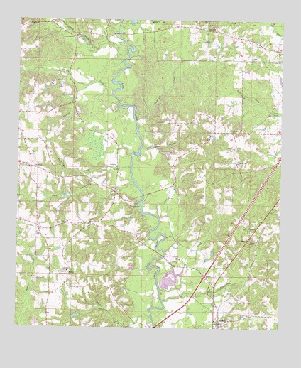
Moselle, MS USGS Topographic Map
Click on map above to begin viewing in our Map Viewer.

This topographic map contains these locations and features:
Feature Name Type Latitude Longitude GNIS ID View Map
Anderson Water Mill (historical)LocaleN31.5532°W89.3501°685446View Map
Austin and Thrash Catfish Ponds DamDamN31.5168°W89.3017°680741View Map
Benson CemeteryCemeteryN31.5357°W89.2642°666830View Map
Burr CreekStreamN31.5152°W89.3067°667835View Map
Cranfords BridgeBridgeN31.6196°W89.3276°685474View Map
Crosby BridgeBridgeN31.5507°W89.3178°685475View Map
Crosby CemeteryCemeteryN31.5499°W89.3206°668961View Map
Crosby Store (historical)LocaleN31.5510°W89.3292°685476View Map
Cross Roads School (historical)SchoolN31.5327°W89.2923°707341View Map
Crossroads CemeteryCemeteryN31.5654°W89.3695°668977View Map
Crossroads ChurchChurchN31.5324°W89.2912°668978View Map
Fairfield CemeteryCemeteryN31.5429°W89.3523°707348View Map
Fairfield ChurchChurchN31.5424°W89.3520°669874View Map
Four Forks CreekStreamN31.5449°W89.3081°670127View Map
Francis Lowery Lake DamDamN31.5535°W89.3517°680759View Map
Gales BranchStreamN31.5363°W89.3112°685497View Map
Gandy CemeteryCemeteryN31.5718°W89.3076°670309View Map
Haskins Ferry (historical)CrossingN31.6007°W89.3309°685504View Map
Hillcrest ChurchChurchN31.6232°W89.3698°671217View Map
Hinton CemeteryCemeteryN31.6086°W89.2507°671241View Map
Hinton ChurchChurchN31.6132°W89.2517°671243View Map
Hinton School (historical)SchoolN31.6132°W89.2517°685506View Map
Hoskins CreekStreamN31.5843°W89.3195°671511View Map
Interchange 80CrossingN31.5213°W89.2853°691486View Map
Jordan CemeteryCemeteryN31.5671°W89.2692°672017View Map
L D Emmons Pond DamDamN31.5018°W89.3467°680731View Map
Lone Star ChurchChurchN31.5649°W89.3673°672787View Map
Lowery CreekStreamN31.5960°W89.3303°691575View Map
Mill BranchStreamN31.5743°W89.3156°673582View Map
Mill CreekStreamN31.5113°W89.3056°691581View Map
MosellePopulated PlaceN31.5024°W89.2789°673862View Map
Moselle Post OfficePost OfficeN31.5097°W89.2794°2768691View Map
Moselle Volunteer Fire DepartmentBuildingN31.5020°W89.2781°2668005View Map
Mount Pleasant ChurchChurchN31.5360°W89.2651°674221View Map
Napier Mills (historical)LocaleN31.5577°W89.3198°685548View Map
New Bethany CemeteryCemeteryN31.6182°W89.3487°707378View Map
New Bethany ChurchChurchN31.6179°W89.3492°674568View Map
New Bethlehem Church (historical)ChurchN31.6204°W89.3170°685549View Map
Oak Barry Church (historical)ChurchN31.6174°W89.3484°685554View Map
Oakey Woods CreekStreamN31.6082°W89.3259°691589View Map
Parker CreekStreamN31.5052°W89.3106°675461View Map
Parkers Store (historical)LocaleN31.6032°W89.3509°685559View Map
Pine Grove CemeteryCemeteryN31.5799°W89.2737°707384View Map
Pine Grove ChurchChurchN31.5796°W89.2728°675826View Map
Pine Grove School (historical)SchoolN31.5802°W89.2745°685566View Map
Pleasant Ridge ChurchChurchN31.5421°W89.3409°676102View Map
Pleasant Ridge School (historical)SchoolN31.5424°W89.3412°707385View Map
RaineyPopulated PlaceN31.5213°W89.3506°692165View Map
Rainey SchoolSchoolN31.5232°W89.3509°685577View Map
Rice Mill CreekStreamN31.5649°W89.3212°676625View Map
Riverside ChurchChurchN31.5766°W89.3642°676682View Map
Sand HillPopulated PlaceN31.6207°W89.2817°692205View Map
Sand Hill School (historical)SchoolN31.6241°W89.2851°707390View Map
Shiloh ChurchChurchN31.5416°W89.2637°677678View Map
Slidell School (historical)SchoolN31.6227°W89.3142°685594View Map
Snows CreekStreamN31.5579°W89.3195°691616View Map
South Jones Volunteer Fire DepartmentBuildingN31.5805°W89.2743°2668066View Map
Southwest Jones Volunteer Fire DepartmentBuildingN31.5220°W89.3505°2668004View Map
Sweetwater ChurchChurchN31.5652°W89.3278°678493View Map
Sweetwater School (historical)SchoolN31.5621°W89.3695°685604View Map
Tisdale BranchStreamN31.5985°W89.3420°678780View Map
Wallace Store (historical)LocaleN31.5418°W89.3403°685613View Map
Windham Ferry (historical)CrossingN31.5213°W89.3081°685621View Map

Note: Coordinates in the location and feature list above are referenced to NAD83 datum.


Copyright (C) 2008-2024 Ryan Niemi / Sunset Dynamics ... All Rights Reserved