TopoQuest Logo
Do you find TopoQuest useful?
Help keep TopoQuest running and adding new maps/features by donating!
Bitcoin:  19c7KJd3qBynnjoSw5npx9KScwjBe4ifkT
Litecoin:  LXs6TkuXGGXo1vDsWCkWVdjQX94eUKd6ui
Home View Maps Find Maps Find Places Resources & Links


Morgantown, Mississippi Topographic Map

USGS Map Title: Morgantown, MS
USGS Map MRC: 31089C8
DRG (GeoTIFF) Download: o31089c8.tif


Neighboring USGS Topographic Map Quads:


  Tilton, MS  
31090D1
 

  Oak Vale, MS  
31089D8
 

  Bunker Hill, MS  
31089D7
 

  Darbun, MS  
31090C1
 

  Morgantown, MS  
31089C8
 

  Columbia North, MS  
31089C7
 

  Kokomo, MS  
31090B1
 

  Sandy Hook NW, MS  
31089B8
 

  Columbia South, MS  
31089B7


Map MRC Location:

N32°
W90°
N32°
W89°
H8 H7 H6 H5 H4 H3 H2 H1
G8 G7 G6 G5 G4 G3 G2 G1
F8 F7 F6 F5 F4 F3 F2 F1
E8 E7 E6 E5 E4 E3 E2 E1
D8 D7 D6 D5 D4 D3 D2 D1
C8 C7 C6 C5 C4 C3 C2 C1
B8 B7 B6 B5 B4 B3 B2 B1
A8 A7 A6 A5 A4 A3 A2 A1
N31°
W90°
N31°
W89°

Morgantown, MS USGS 1:24K Topographic Map Preview:
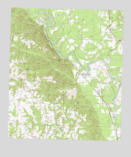
Morgantown, MS USGS Topographic Map
Click on map above to begin viewing in our Map Viewer.

This topographic map contains these locations and features:
Feature Name Type Latitude Longitude GNIS ID View Map
Buford Consolidated School (historical)SchoolN31.2671°W89.9906°710514View Map
Circle Bar Ranch AirportAirportN31.2932°W89.9832°2676404View Map
Cypress CreekStreamN31.3327°W89.9448°669049View Map
Dry CreekStreamN31.3338°W89.9004°669451View Map
Fenny CreekStreamN31.3118°W89.8795°669946View Map
GossPopulated PlaceN31.3555°W89.8887°670553View Map
Goss Baptist ChurchChurchN31.3577°W89.8881°689675View Map
Goss School (historical)SchoolN31.3580°W89.8887°710541View Map
Greens Creek Oil FieldOilfieldN31.3641°W89.9251°689676View Map
Holiday CreekStreamN31.3277°W89.8970°671285View Map
Holly SpringsPopulated PlaceN31.3157°W89.9779°691939View Map
Holly Springs CemeteryCemeteryN31.3163°W89.9773°710545View Map
Holly Springs ChurchChurchN31.3155°W89.9773°710546View Map
Lightville (historical)Populated PlaceN31.3432°W89.8787°689683View Map
MorgantownPopulated PlaceN31.3124°W89.9159°673812View Map
Morgantown CemeteryCemeteryN31.3099°W89.9237°710557View Map
Morgantown Church of GodChurchN31.3131°W89.9192°2597046View Map
Morgantown High SchoolSchoolN31.3135°W89.9184°710558View Map
Morgantown Oil FieldOilfieldN31.3071°W89.9056°689688View Map
Mount Sinai CemeteryCemeteryN31.2952°W89.9817°710561View Map
Mount Sinai ChurchChurchN31.2955°W89.9815°674268View Map
NewsomPopulated PlaceN31.3263°W89.9342°692106View Map
Newson Oil FieldOilfieldN31.3321°W89.8765°689692View Map
Oak Grove CemeteryCemeteryN31.2966°W89.8984°710566View Map
Oak Grove ChurchChurchN31.2966°W89.8984°675021View Map
Pierce CreekStreamN31.3307°W89.8979°675719View Map
Red BluffCliffN31.3255°W89.9459°676517View Map
Richland Creek CemeteryCemeteryN31.2596°W89.9423°710589View Map
Richland Creek ChurchChurchN31.2591°W89.9423°676644View Map
Smith CemeteryCemeteryN31.2552°W89.9567°677901View Map
Supervisor District 3CivilN31.2756°W89.9532°711979View Map
Tri - Community Volunteer Fire Department Station 2BuildingN31.3559°W89.8887°2667875View Map
Twitty CreekStreamN31.3074°W89.8754°679013View Map
White BluffPopulated PlaceN31.3649°W89.9659°692316View Map
White Bluff ChurchChurchN31.3691°W89.9798°679567View Map

Note: Coordinates in the location and feature list above are referenced to NAD83 datum.


Copyright (C) 2008-2024 Ryan Niemi / Sunset Dynamics ... All Rights Reserved