TopoQuest Logo
Do you find TopoQuest useful?
Help keep TopoQuest running and adding new maps/features by donating!
Bitcoin:  19c7KJd3qBynnjoSw5npx9KScwjBe4ifkT
Litecoin:  LXs6TkuXGGXo1vDsWCkWVdjQX94eUKd6ui
Home View Maps Find Maps Find Places Resources & Links


Morgan, Georgia Topographic Map

USGS Map Title: Morgan, GA
USGS Map MRC: 31084E5
DRG (GeoTIFF) Download: o31084e5.tif


Neighboring USGS Topographic Map Quads:


  Martins Crossroads, GA  
31084F6
 

  Doverel, GA  
31084F5
 

  Chickasawhatchee, GA  
31084F4
 

  Edison, GA  
31084E6
 

  Morgan, GA  
31084E5
 

  Holt, GA  
31084E4
 

  Arlington, GA  
31084D6
 

  Leary, GA  
31084D5
 

  Bermuda, GA  
31084D4


Map MRC Location:

N32°
W85°
N32°
W84°
H8 H7 H6 H5 H4 H3 H2 H1
G8 G7 G6 G5 G4 G3 G2 G1
F8 F7 F6 F5 F4 F3 F2 F1
E8 E7 E6 E5 E4 E3 E2 E1
D8 D7 D6 D5 D4 D3 D2 D1
C8 C7 C6 C5 C4 C3 C2 C1
B8 B7 B6 B5 B4 B3 B2 B1
A8 A7 A6 A5 A4 A3 A2 A1
N31°
W85°
N31°
W84°

Morgan, GA USGS 1:24K Topographic Map Preview:
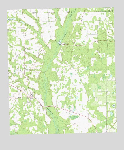
Morgan, GA USGS Topographic Map
Click on map above to begin viewing in our Map Viewer.

This topographic map contains these locations and features:
Feature Name Type Latitude Longitude GNIS ID View Map
Calhoun CountyCivilN31.5292°W84.6245°344074View Map
Calhoun County CourthouseBuildingN31.5374°W84.5996°335053View Map
Calhoun County Emergency Management Agency Fire and Rescue HeadquartersBuildingN31.5384°W84.6099°2604028View Map
Calhoun County Sheriff's OfficeBuildingN31.5383°W84.5992°2733502View Map
Calhoun State PrisonBuildingN31.5397°W84.6168°2735720View Map
Calhoun State Prison Fire ServicesBuildingN31.5415°W84.6172°2604963View Map
City of MorganCivilN31.5381°W84.6032°2404300View Map
Conley CemeteryCemeteryN31.6124°W84.5188°335057View Map
Cordray ChurchChurchN31.5916°W84.5085°312972View Map
Cordray ChurchChurchN31.5913°W84.5221°355306View Map
Cordrays MillPopulated PlaceN31.5891°W84.5632°326236View Map
Cordrays PondLakeN31.5922°W84.5642°312973View Map
East Calhoun Division (historical)CensusN31.5218°W84.5538°1936235View Map
Elam CemeteryCemeteryN31.6124°W84.5727°335062View Map
Elam ChurchChurchN31.6116°W84.5730°313883View Map
Falling CreekStreamN31.6002°W84.5580°314071View Map
Folks (historical)Populated PlaceN31.6196°W84.6063°335064View Map
Joiner PondLakeN31.5270°W84.5026°316197View Map
Leary DivisionCivilN31.5232°W84.5052°1936355View Map
Little CreekStreamN31.5418°W84.5810°317026View Map
McClendon LakeReservoirN31.5161°W84.5497°338348View Map
McClendon Lake DamDamN31.5152°W84.5532°338347View Map
Merrett CreekStreamN31.5677°W84.5791°318045View Map
Merrett PondReservoirN31.6155°W84.6197°318046View Map
Merrett Pond DamDamN31.6154°W84.6149°341967View Map
MorganPopulated PlaceN31.5377°W84.5994°318451View Map
Morgan Baptist ChurchChurchN31.5377°W84.5469°335072View Map
Morgan CemeteryCemeteryN31.5374°W84.5952°335073View Map
Morgan CemeteryCemeteryN31.5382°W84.5971°335074View Map
Morgan Methodist ChurchChurchN31.5371°W84.5966°335075View Map
Morgan Volunteer Fire DepartmentBuildingN31.5383°W84.5988°2604147View Map
Mosh BranchStreamN31.5088°W84.6105°318515View Map
Mount Carmel CemeteryCemeteryN31.5882°W84.5413°335076View Map
Mount Carmel ChurchChurchN31.5879°W84.5407°318595View Map
Mount Nebo CemeteryCemeteryN31.5954°W84.6002°335077View Map
Mount Nebo ChurchChurchN31.5991°W84.6044°318707View Map
Mount Zion ChurchChurchN31.5227°W84.5541°318950View Map
New Light CemeteryCemeteryN31.5849°W84.6049°335078View Map
New Light ChurchChurchN31.5854°W84.6046°319467View Map
Oak Grove Church (historical)ChurchN31.6124°W84.5182°335080View Map
Pilgrims Rest ChurchChurchN31.6129°W84.6046°335081View Map
Pruitt CreekStreamN31.5991°W84.5882°321211View Map
Saint Maryland ChurchChurchN31.5055°W84.5244°335084View Map
Saint Marys Land CemeteryCemeteryN31.5052°W84.5249°335085View Map
Saint Peters ChurchChurchN31.5227°W84.5341°322293View Map
Singleton Junior High SchoolSchoolN31.5316°W84.6005°323034View Map

Note: Coordinates in the location and feature list above are referenced to NAD83 datum.


Copyright (C) 2008-2024 Ryan Niemi / Sunset Dynamics ... All Rights Reserved