TopoQuest Logo
Do you find TopoQuest useful?
Help keep TopoQuest running and adding new maps/features by donating!
Bitcoin:  19c7KJd3qBynnjoSw5npx9KScwjBe4ifkT
Litecoin:  LXs6TkuXGGXo1vDsWCkWVdjQX94eUKd6ui
Home View Maps Find Maps Find Places Resources & Links


Moodys, Oklahoma Topographic Map

USGS Map Title: Moodys, OK
USGS Map MRC: 36094A8
DRG (GeoTIFF) Download: o36094a8.tif


Neighboring USGS Topographic Map Quads:


  Rose, OK  
36095B1
 

  Leach, OK  
36094B8
 

  Kansas, OK  
36094B7
 

  Peggs, OK  
36095A1
 

  Moodys, OK  
36094A8
 

  Chewey, OK  
36094A7
 

  Thompson Corner, OK  
35095H1
 

  Tahlequah, OK  
35094H8
 

  Proctor, OK  
35094H7


Map MRC Location:

N37°
W95°
N37°
W94°
H8 H7 H6 H5 H4 H3 H2 H1
G8 G7 G6 G5 G4 G3 G2 G1
F8 F7 F6 F5 F4 F3 F2 F1
E8 E7 E6 E5 E4 E3 E2 E1
D8 D7 D6 D5 D4 D3 D2 D1
C8 C7 C6 C5 C4 C3 C2 C1
B8 B7 B6 B5 B4 B3 B2 B1
A8 A7 A6 A5 A4 A3 A2 A1
N36°
W95°
N36°
W94°

Moodys, OK USGS 1:24K Topographic Map Preview:
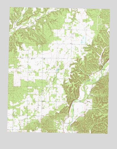
Moodys, OK USGS Topographic Map
Click on map above to begin viewing in our Map Viewer.

This topographic map contains these locations and features:
Feature Name Type Latitude Longitude GNIS ID View Map
Agent CemeteryCemeteryN36.0420°W94.9583°1089552View Map
Combs BridgeBridgeN36.0318°W94.9111°1091592View Map
Double Spring CreekStreamN36.1045°W94.9930°1092154View Map
Eagles BluffCliffN36.0315°W94.9197°1092335View Map
EllervillePopulated PlaceN36.0312°W94.9022°1100388View Map
Faith ChapelChurchN36.0020°W94.9666°1092742View Map
Fourteen Mile Creek Site 1 DamDamN36.0634°W94.9402°1751722View Map
Fourteen Mile Creek Site 1 ReservoirReservoirN36.0633°W94.9394°1751723View Map
Fourteen Mile Creek Site 2 DamDamN36.0201°W94.9902°1755765View Map
Fourteen Mile Creek Site 2 ReservoirReservoirN36.0218°W94.9914°1755766View Map
Grace ChapelChurchN36.0743°W94.9566°1093282View Map
Hanging RockCliffN36.0668°W94.8833°1093511View Map
Johnson PrairieCivilN36.0806°W94.9946°2631116View Map
Johnson Prairie ChurchChurchN36.0740°W94.9719°1094250View Map
LibertyPopulated PlaceN36.0748°W94.9808°1100578View Map
LowreyCivilN36.0989°W94.9040°2631126View Map
LowreyPopulated PlaceN36.0981°W94.9222°1100595View Map
Lowrey Elementary SchoolSchoolN36.0897°W94.9206°1095040View Map
Lowrey Volunteer Fire Department Station 1BuildingN36.0347°W94.9585°2657239View Map
Lowrey Volunteer Fire Department Station 2BuildingN36.0599°W94.9533°2657057View Map
Lowrey Volunteer Fire Department Station 3BuildingN36.0894°W94.9197°2657085View Map
Molly Field CemeteryCemeteryN36.0589°W94.8989°2711313View Map
Molly Field ChurchChurchN36.0581°W94.8988°1095471View Map
Molly Field HollowValleyN36.0570°W94.8974°1095472View Map
MoodysPopulated PlaceN36.0312°W94.9577°1100642View Map
MoodysCivilN36.0332°W94.9641°2631135View Map
Moodys CemeteryCemeteryN36.0318°W94.9527°2711314View Map
North Cherokee DivisionCivilN36.0802°W94.9824°1937787View Map
Olive ChurchChurchN36.0256°W94.9627°1096257View Map
Peavine HollowValleyN36.0681°W94.8824°1096514View Map
Peavine Hollow Public Access AreaParkN36.0643°W94.8844°1096515View Map
Pumpkin SpringSpringN36.0098°W94.9300°1096961View Map
Telamay HollowValleyN36.0382°W94.8989°1098791View Map
TeresitaPopulated PlaceN36.1095°W94.9927°1100881View Map
Teresita CemeteryCemeteryN36.1048°W94.9936°1098810View Map
Teresita Census Designated PlaceCensusN36.1230°W94.9803°2584393View Map
Township of MoodysCivilN36.0640°W94.9405°1824586View Map

Note: Coordinates in the location and feature list above are referenced to NAD83 datum.


Copyright (C) 2008-2024 Ryan Niemi / Sunset Dynamics ... All Rights Reserved