TopoQuest Logo
Do you find TopoQuest useful?
Help keep TopoQuest running and adding new maps/features by donating!
Bitcoin:  19c7KJd3qBynnjoSw5npx9KScwjBe4ifkT
Litecoin:  LXs6TkuXGGXo1vDsWCkWVdjQX94eUKd6ui
Home View Maps Find Maps Find Places Resources & Links


Bedford, Louisiana Topographic Map

USGS Map Title: Bedford, LA
USGS Map MRC: 32091B1
DRG (GeoTIFF) Download: o32091b1.tif


Neighboring USGS Topographic Map Quads:


  Fortune Fork, LA  
32091C2
 

  Mound, LA  
32091C1
 

  Vicksburg West, MS  
32090C8
 

  Somerset, LA  
32091B2
 

  Bedford, LA  
32091B1
 

  Yokena, MS  
32090B8
 

  Newellton, LA  
32091A2
 

  Grand Gulf, MS  
32091A1
 

  Willows, MS  
32090A8


Map MRC Location:

N33°
W92°
N33°
W91°
H8 H7 H6 H5 H4 H3 H2 H1
G8 G7 G6 G5 G4 G3 G2 G1
F8 F7 F6 F5 F4 F3 F2 F1
E8 E7 E6 E5 E4 E3 E2 E1
D8 D7 D6 D5 D4 D3 D2 D1
C8 C7 C6 C5 C4 C3 C2 C1
B8 B7 B6 B5 B4 B3 B2 B1
A8 A7 A6 A5 A4 A3 A2 A1
N32°
W92°
N32°
W91°

Bedford, LA USGS 1:24K Topographic Map Preview:
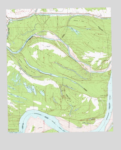
Bedford, LA USGS Topographic Map
Click on map above to begin viewing in our Map Viewer.

This topographic map contains these locations and features:
Feature Name Type Latitude Longitude GNIS ID View Map
Bayou VidalLakeN32.2241°W91.1232°532806View Map
BedfordPopulated PlaceN32.2410°W91.0151°553566View Map
BHLLC AirportAirportN32.1556°W91.1236°680334View Map
Blue HoleLakeN32.1541°W91.0521°667291View Map
Blue LakeLakeN32.1502°W91.0482°553725View Map
Brierfield (historical)LocaleN32.1532°W91.1209°686310View Map
Brierfield CemeteryCemeteryN32.1524°W91.1209°1700711View Map
Cook LakeLakeN32.2287°W91.0240°668781View Map
Coxs Towing Company Lake DamDamN32.1252°W91.0184°681018View Map
Crystal Springs CemeteryCemeteryN32.2396°W91.0151°534296View Map
Cypress LakeLakeN32.1697°W91.0978°669060View Map
Davis IslandIslandN32.1549°W91.0443°534408View Map
Davis IslandAreaN32.1618°W91.0746°669145View Map
Davis Island BendBendN32.1432°W91.1015°686319View Map
Diamond IslandAreaN32.2374°W91.0371°669247View Map
Diamond Island TowheadAreaN32.1954°W91.0159°669248View Map
Diamond PointCapeN32.2068°W91.0804°669251View Map
Diamond Point Landing Strip (historical)AirportN32.2121°W91.0782°1700712View Map
Diamond RevetmentLeveeN32.1596°W91.0062°549503View Map
Duck LakeLakeN32.1713°W91.1208°669474View Map
Hodge LandingLocaleN32.2254°W91.0690°549231View Map
Hodges CanalCanalN32.2371°W91.0646°554719View Map
Hodges CemeteryCemeteryN32.2460°W91.0426°535687View Map
Hodges LakeLakeN32.2241°W91.0420°554720View Map
John Thomas LakeLakeN32.1660°W91.0608°671902View Map
Kellogg LandingLocaleN32.1593°W91.0254°549239View Map
Killikrankia CutoffChannelN32.2113°W91.1240°549518View Map
Killikrankia Plantation (historical)LocaleN32.1960°W91.0979°707660View Map
KingPopulated PlaceN32.2407°W91.1215°543354View Map
Long LakeLakeN32.1632°W91.1162°672844View Map
Long LakeLakeN32.1700°W91.0507°555151View Map
Newton Bend BarBarN32.1388°W91.0021°686357View Map
Newtown BendBendN32.1371°W91.0079°686358View Map
Oak BendBendN32.1849°W91.0004°686359View Map
Old ChuteLakeN32.1870°W91.1042°675172View Map
Palmyra (historical)LocaleN32.1765°W91.0696°686365View Map
Palmyra ChuteStreamN32.2063°W91.1104°675420View Map
Palmyra Island Number One Hundred SixAreaN32.1893°W91.0987°675421View Map
Palmyra LakeLakeN32.2237°W91.0912°675422View Map
Parker Landing Strip (historical)AirportN32.1857°W91.1071°1700713View Map
Pilgrim Rest ChurchChurchN32.2435°W91.0209°549257View Map
Pilgrim Rest School (historical)SchoolN32.2435°W91.0207°549506View Map
River LakeLakeN32.1340°W91.0317°555806View Map
Sandbar LakeLakeN32.1381°W91.0270°555971View Map
Sargent PointCapeN32.1560°W91.0071°539186View Map
Ursino (historical)LocaleN32.1496°W91.0676°686389View Map
Ursino BarBarN32.1346°W91.0696°686390View Map
Ursino Landing (historical)LocaleN32.1415°W91.0690°686391View Map

Note: Coordinates in the location and feature list above are referenced to NAD83 datum.


Copyright (C) 2008-2024 Ryan Niemi / Sunset Dynamics ... All Rights Reserved