TopoQuest Logo
Do you find TopoQuest useful?
Help keep TopoQuest running and adding new maps/features by donating!
Bitcoin:  19c7KJd3qBynnjoSw5npx9KScwjBe4ifkT
Litecoin:  LXs6TkuXGGXo1vDsWCkWVdjQX94eUKd6ui
Home View Maps Find Maps Find Places Resources & Links


Montier, Missouri Topographic Map

USGS Map Title: Montier, MO
USGS Map MRC: 36091H5
DRG (GeoTIFF) Download: o36091h5.tif


Neighboring USGS Topographic Map Quads:


  Pine Crest, MO  
37091A6
 

  Jam Up Cave, MO  
37091A5
 

  Bartlett, MO  
37091A4
 

  Mountain View, MO  
36091H6
 

  Montier, MO  
36091H5
 

  Birch Tree, MO  
36091H4
 

  Peace Valley, MO  
36091G6
 

  Thomasville, MO  
36091G5
 

  Piedmont Hollow, MO  
36091G4


Map MRC Location:

N37°
W92°
N37°
W91°
H8 H7 H6 H5 H4 H3 H2 H1
G8 G7 G6 G5 G4 G3 G2 G1
F8 F7 F6 F5 F4 F3 F2 F1
E8 E7 E6 E5 E4 E3 E2 E1
D8 D7 D6 D5 D4 D3 D2 D1
C8 C7 C6 C5 C4 C3 C2 C1
B8 B7 B6 B5 B4 B3 B2 B1
A8 A7 A6 A5 A4 A3 A2 A1
N36°
W92°
N36°
W91°

Montier, MO USGS 1:24K Topographic Map Preview:
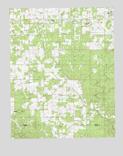
Montier, MO USGS Topographic Map
Click on map above to begin viewing in our Map Viewer.

This topographic map contains these locations and features:
Feature Name Type Latitude Longitude GNIS ID View Map
Bethlehem CemeteryCemeteryN36.8862°W91.5685°2041675View Map
Bethlehem ChurchChurchN36.8862°W91.5682°714107View Map
Birch CreekStreamN36.9073°W91.5229°748865View Map
Brown CemeteryCemeteryN36.9674°W91.5009°714771View Map
Congo (historical)Populated PlaceN36.9392°W91.6021°740476View Map
Congo SchoolSchoolN36.9459°W91.6146°716189View Map
Corinth ChurchChurchN36.8878°W91.5382°716320View Map
Corinth SchoolSchoolN36.9178°W91.5649°716321View Map
County Line ChurchChurchN36.8878°W91.5351°730010View Map
High HillSummitN36.9006°W91.6126°719522View Map
Hunter Hill School (historical)SchoolN36.9673°W91.5004°720017View Map
KBMV-AM (Birch Tree)TowerN36.9853°W91.5485°754286View Map
KBMV-FM (Birch Tree)TowerN36.9853°W91.5485°754254View Map
Marble Hill School (historical)SchoolN36.9101°W91.6176°721857View Map
MontierPopulated PlaceN36.9870°W91.5754°722548View Map
Montier Census Designated PlaceCensusN36.9816°W91.5749°2587092View Map
Mount Calvary ChurchChurchN36.9287°W91.6029°722724View Map
New Salem CemeteryCemeteryN36.9239°W91.6029°723301View Map
NotPopulated PlaceN36.8953°W91.5804°740477View Map
Pleasant Grove ChurchChurchN36.9739°W91.6207°724498View Map
Thomasville Tower SiteLocaleN36.9009°W91.6143°743130View Map
Township of Spring CreekCivilN36.9269°W91.5875°767403View Map

Note: Coordinates in the location and feature list above are referenced to NAD83 datum.


Copyright (C) 2008-2024 Ryan Niemi / Sunset Dynamics ... All Rights Reserved