TopoQuest Logo
Do you find TopoQuest useful?
Help keep TopoQuest running and adding new maps/features by donating!
Bitcoin:  19c7KJd3qBynnjoSw5npx9KScwjBe4ifkT
Litecoin:  LXs6TkuXGGXo1vDsWCkWVdjQX94eUKd6ui
Home View Maps Find Maps Find Places Resources & Links


Monticello, Florida Topographic Map

USGS Map Title: Monticello, FL
USGS Map MRC: 30083E7
DRG (GeoTIFF) Download: o30083e7.tif


Neighboring USGS Topographic Map Quads:


  Metcalf, GA  
30083F8
 

  Monticello NE, FL  
30083F7
 

  Grooverville, GA  
30083F6
 

  Lake Miccosukee, FL  
30083E8
 

  Monticello, FL  
30083E7
 

  Ashville, FL  
30083E6
 

  Waukeenah, FL  
30083D8
 

  Lamont, FL  
30083D7
 

  Greenville, FL  
30083D6


Map MRC Location:

N31°
W84°
N31°
W83°
H8 H7 H6 H5 H4 H3 H2 H1
G8 G7 G6 G5 G4 G3 G2 G1
F8 F7 F6 F5 F4 F3 F2 F1
E8 E7 E6 E5 E4 E3 E2 E1
D8 D7 D6 D5 D4 D3 D2 D1
C8 C7 C6 C5 C4 C3 C2 C1
B8 B7 B6 B5 B4 B3 B2 B1
A8 A7 A6 A5 A4 A3 A2 A1
N30°
W84°
N30°
W83°

Monticello, FL USGS 1:24K Topographic Map Preview:
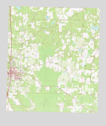
Monticello, FL USGS Topographic Map
Click on map above to begin viewing in our Map Viewer.

This topographic map contains these locations and features:
Feature Name Type Latitude Longitude GNIS ID View Map
Bellamy CemeteryCemeteryN30.5385°W83.7968°278443View Map
Bethel African Methodist Episcopal ChurchChurchN30.5483°W83.8675°2450821View Map
Bethel ChurchChurchN30.6155°W83.8388°300042View Map
Bethel SchoolSchoolN30.6155°W83.8377°278558View Map
Browns CemeteryCemeteryN30.5527°W83.8518°279491View Map
Calvary Baptist ChurchChurchN30.5464°W83.8676°2450822View Map
Central Church of ChristChurchN30.5261°W83.8731°2450823View Map
Christ Episcopal ChurchChurchN30.5475°W83.8690°2450824View Map
Church of ChristChurchN30.5421°W83.8699°2450825View Map
City of MonticelloCivilN30.5422°W83.8722°2404293View Map
City of Monticello Sewage Treatment PlantLocaleN30.5549°W83.8612°2450813View Map
DillsPopulated PlaceN30.6233°W83.7721°294746View Map
Elizabeth CemeteryCemeteryN30.5213°W83.7585°282155View Map
Elizabeth ChurchChurchN30.5227°W83.7663°282158View Map
Elizabeth Missionary Baptist ChurchChurchN30.5829°W83.8499°2450826View Map
First Presbyterian ChurchChurchN30.5460°W83.8687°2450827View Map
First United Methodist ChurchChurchN30.5449°W83.8708°2450828View Map
Fourth Street Trailer ParkPopulated PlaceN30.5373°W83.8614°2450817View Map
Greater Fellowship Baptist ChurchChurchN30.5514°W83.8658°2450829View Map
Hay PondLakeN30.6125°W83.8217°283832View Map
Hickory Hill ChurchChurchN30.5580°W83.8093°283961View Map
Howard AcademySchoolN30.5388°W83.8579°284339View Map
Howard Middle SchoolSchoolN30.5388°W83.8581°298462View Map
Jefferson Correctional InstitutionBuildingN30.5098°W83.8008°2450819View Map
Jefferson Correctional Institution LibraryBuildingN30.5098°W83.8004°2450815View Map
Jefferson County Adult CenterSchoolN30.5460°W83.8749°298465View Map
Jefferson County Elementary School-Mamie Scott AnnexSchoolN30.5419°W83.8652°298463View Map
Jefferson County Fire Rescue ServiceBuildingN30.5296°W83.8696°2644452View Map
June PondLakeN30.5573°W83.7697°284978View Map
Kingdom Hall of Jehovahs WitnessesChurchN30.5540°W83.8460°2450831View Map
Kinsey CemeteryCemeteryN30.5133°W83.7849°285137View Map
Lakeview AirstripAirportN30.5290°W83.8585°2770285View Map
Macedonia ChurchChurchN30.5371°W83.7857°286253View Map
Milton CemeteryCemeteryN30.5594°W83.8140°286948View Map
MonticelloPopulated PlaceN30.5452°W83.8702°287080View Map
Monticello Church of God in ChristChurchN30.5430°W83.8653°2450832View Map
Monticello DivisionCivilN30.5738°W83.8277°1935858View Map
Monticello Opera HouseBuildingN30.5454°W83.8714°2450814View Map
Monticello Police DepartmentBuildingN30.5446°W83.8712°2333113View Map
Monticello Post OfficePost OfficeN30.5464°W83.8704°2450816View Map
Monticello Volunteer Fire DepartmentBuildingN30.5557°W83.8705°2644036View Map
Mount Zion CemeteryCemeteryN30.6060°W83.8429°287334View Map
New Bethel ChurchChurchN30.5885°W83.7579°287601View Map
New Zion ChurchChurchN30.5591°W83.8160°287708View Map
Philadelphia ChurchChurchN30.5999°W83.8263°288758View Map
Pleasant Grove ChurchChurchN30.5669°W83.7560°289054View Map
Razor LakeLakeN30.6011°W83.7555°289522View Map
Roseland CemeteryCemeteryN30.5499°W83.8674°289970View Map
Silver LakeLakeN30.5747°W83.7754°291126View Map
Simpson LakeReservoirN30.5638°W83.8492°291158View Map
Simpson Nursery PondLakeN30.5580°W83.7513°298247View Map
Sneeds CemeteryCemeteryN30.5374°W83.8560°291301View Map
Texas HillSummitN30.5566°W83.8716°292143View Map
Texas Hill CemeteryCemeteryN30.5605°W83.8696°292144View Map
WJPH-FM (Monticello)TowerN30.5330°W83.8713°309074View Map
WMFL-AM (Monticello)TowerN30.5330°W83.8713°308793View Map

Note: Coordinates in the location and feature list above are referenced to NAD83 datum.


Copyright (C) 2008-2024 Ryan Niemi / Sunset Dynamics ... All Rights Reserved