TopoQuest Logo
Do you find TopoQuest useful?
Help keep TopoQuest running and adding new maps/features by donating!
Bitcoin:  19c7KJd3qBynnjoSw5npx9KScwjBe4ifkT
Litecoin:  LXs6TkuXGGXo1vDsWCkWVdjQX94eUKd6ui
Home View Maps Find Maps Find Places Resources & Links


Monteagle, Tennessee Topographic Map

USGS Map Title: Monteagle, TN
USGS Map MRC: 35085B7
DRG (GeoTIFF) Download: o35085b7.tif


Neighboring USGS Topographic Map Quads:


  Alto, TN  
35085C8
 

  Burrow Cove, TN  
35085C7
 

  Tracy City, TN  
35085C6
 

  Sewanee, TN  
35085B8
 

  Monteagle, TN  
35085B7
 

  White City, TN  
35085B6
 

  Sinking Cove, TN  
35085A8
 

  Orme, TN  
35085A7
 

  South Pittsburg, TN  
35085A6


Map MRC Location:

N36°
W86°
N36°
W85°
H8 H7 H6 H5 H4 H3 H2 H1
G8 G7 G6 G5 G4 G3 G2 G1
F8 F7 F6 F5 F4 F3 F2 F1
E8 E7 E6 E5 E4 E3 E2 E1
D8 D7 D6 D5 D4 D3 D2 D1
C8 C7 C6 C5 C4 C3 C2 C1
B8 B7 B6 B5 B4 B3 B2 B1
A8 A7 A6 A5 A4 A3 A2 A1
N35°
W86°
N35°
W85°

Monteagle, TN USGS 1:24K Topographic Map Preview:
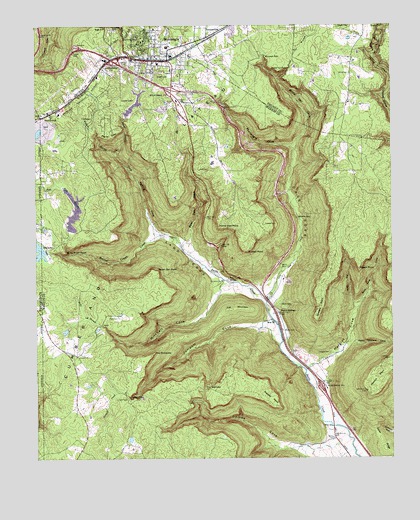
Monteagle, TN USGS Topographic Map
Click on map above to begin viewing in our Map Viewer.

This topographic map contains these locations and features:
Feature Name Type Latitude Longitude GNIS ID View Map
Adams Mill (historical)LocaleN35.1576°W85.7897°1309987View Map
Alpine View PointCapeN35.1920°W85.8111°1275636View Map
Bear Den CoveValleyN35.1876°W85.8222°1276608View Map
Bethel CreekStreamN35.1848°W85.8239°1305155View Map
Bethel Creek CoveValleyN35.1897°W85.8330°1305156View Map
Bridal Veil CoveValleyN35.2144°W85.7845°1278337View Map
Bridal Veil CreekStreamN35.2351°W85.7903°1278338View Map
Bridal Veil FallsFallsN35.2376°W85.7864°1278339View Map
Cave CoveValleyN35.1707°W85.7933°1279922View Map
Cave Cove CreekStreamN35.1692°W85.7944°1305737View Map
ClifftopsPopulated PlaceN35.2237°W85.8561°1310000View Map
Clifftops LakeReservoirN35.1917°W85.8666°1301649View Map
Clifftops Lake DamDamN35.1917°W85.8666°1301650View Map
Day Lake DamDamN35.1848°W85.8714°1307073View Map
Drip Spring CoveValleyN35.1900°W85.8332°1282792View Map
Dripping Spring Cove BranchStreamN35.1851°W85.8233°1650194View Map
Falls BranchStreamN35.1623°W85.8508°1284100View Map
Falls BranchStreamN35.1840°W85.8630°1284103View Map
Flat MountainSummitN35.1679°W85.8083°1284407View Map
Gaines CoveValleyN35.1281°W85.7711°1285069View Map
Gaines Cove BranchStreamN35.1267°W85.7633°1647273View Map
Grundy State ForestForestN35.2462°W85.7528°1269610View Map
Hargiss CemeteryCemeteryN35.1554°W85.7722°1286865View Map
Hargiss CoveValleyN35.1517°W85.7765°1286867View Map
Hargiss Cove BranchStreamN35.1504°W85.7805°1647274View Map
Hedrick PointCapeN35.1448°W85.7583°1287326View Map
Interchange 134CrossingN35.2404°W85.8483°1310030View Map
Interchange 135CrossingN35.2315°W85.8269°1310031View Map
Interchange 143CrossingN35.1462°W85.7753°1310032View Map
Jumpoff CemeteryCemeteryN35.1420°W85.8433°1289882View Map
Jumpoff ChurchChurchN35.1545°W85.8614°1289883View Map
Jumpoff CoveValleyN35.1628°W85.7933°1289884View Map
Jumpoff Cove BranchStreamN35.1576°W85.7897°1650199View Map
Jumpoff CreekStreamN35.1437°W85.8475°1289885View Map
Jumpoff FallsFallsN35.1429°W85.8425°1289886View Map
Jumpoff School (historical)SchoolN35.1509°W85.8564°1310044View Map
Kirby Smith PointCapeN35.1854°W85.8653°1290288View Map
Klepper PointCapeN35.1398°W85.7903°1314136View Map
Ladd CoveValleyN35.1724°W85.7958°1290458View Map
Lappin CemeteryCemeteryN35.2395°W85.8427°1290632View Map
Laurel BranchStreamN35.2131°W85.8472°1290691View Map
Laurel LakeReservoirN35.2274°W85.8402°1290755View Map
Martin CemeteryCemeteryN35.1617°W85.7886°1292798View Map
Martin CemeteryCemeteryN35.1690°W85.7897°1292799View Map
Martin CemeteryCemeteryN35.1801°W85.7894°1292800View Map
Martin SpringsPopulated PlaceN35.1667°W85.7897°1292848View Map
Martin SpringsSpringN35.1661°W85.7889°1310058View Map
Martin Springs Baptist ChurchChurchN35.1620°W85.7886°1643734View Map
Martin Springs School (historical)SchoolN35.1620°W85.7903°1310059View Map
Mitchell CoveValleyN35.1740°W85.8104°1294103View Map
Mitchell Cove BranchStreamN35.1767°W85.8089°1650208View Map
MonteaglePopulated PlaceN35.2401°W85.8397°1314141View Map
Monteagle CemeteryCemeteryN35.2334°W85.8389°1317583View Map
Monteagle CoveValleyN35.2149°W85.7850°1294182View Map
Monteagle Cove BranchStreamN35.2140°W85.7841°1650209View Map
Monteagle FallsFallsN35.2413°W85.7938°1294183View Map
Monteagle Fire DepartmentBuildingN35.2404°W85.8313°2654403View Map
Monteagle Police DepartmentBuildingN35.2406°W85.8348°2765998View Map
Monteagle Post OfficePost OfficeN35.2383°W85.8270°1649936View Map
Monteagle SchoolSchoolN35.2390°W85.8316°1310064View Map
PalisadesCliffN35.2298°W85.7769°1309352View Map
Payne ViewSummitN35.2179°W85.8489°1297022View Map
Peach Orchard CoveValleyN35.1584°W85.7640°1297046View Map
Pigeon PointCapeN35.1801°W85.7614°1297440View Map
Polly King CoveValleyN35.1698°W85.7607°1298081View Map
Raven Den PointCapeN35.1790°W85.8328°1298968View Map
Ray CoveValleyN35.1690°W85.7635°1298996View Map
Roy Cove BranchStreamN35.1676°W85.7622°1647282View Map
Saint Johns CemeteryCemeteryN35.1765°W85.8094°1317603View Map
Saint Johns ChurchChurchN35.1762°W85.8100°1314153View Map
Speegle PointCapeN35.1654°W85.7764°1270977View Map
Tate Cave SpringSpringN35.1768°W85.8074°1272146View Map
Tate CemeteryCemeteryN35.1656°W85.8464°1272147View Map
The NarrowsGapN35.1448°W85.8164°1272424View Map
The PinnaclesSummitN35.1551°W85.8341°1272430View Map
Tom McBee DamDamN35.1626°W85.8640°1301633View Map
Tom McBee LakeReservoirN35.1619°W85.8647°1301634View Map
Town of MonteagleCivilN35.2289°W85.8727°2406178View Map
Trussell CemeteryCemeteryN35.1926°W85.7952°1272924View Map
Trussell PointCapeN35.1854°W85.8008°1272926View Map
White CemeteryCemeteryN35.2362°W85.7644°1274341View Map
Wildcat BranchStreamN35.2134°W85.8472°1274529View Map

Note: Coordinates in the location and feature list above are referenced to NAD83 datum.


Copyright (C) 2008-2024 Ryan Niemi / Sunset Dynamics ... All Rights Reserved