TopoQuest Logo
Do you find TopoQuest useful?
Help keep TopoQuest running and adding new maps/features by donating!
Bitcoin:  19c7KJd3qBynnjoSw5npx9KScwjBe4ifkT
Litecoin:  LXs6TkuXGGXo1vDsWCkWVdjQX94eUKd6ui
Home View Maps Find Maps Find Places Resources & Links


Monegaw Springs, Missouri Topographic Map

USGS Map Title: Monegaw Springs, MO
USGS Map MRC: 38093A7
DRG (GeoTIFF) Download: o38093a7.tif


Neighboring USGS Topographic Map Quads:


  Monegaw Springs NW, MO  
38093B8
 

  Ohio, MO  
38093B7
 

  Lowry City, MO  
38093B6
 

  Taberville, MO  
38093A8
 

  Monegaw Springs, MO  
38093A7
 

  Osceola, MO  
38093A6
 

  Tiffin, MO  
37093H8
 

  Roscoe, MO  
37093H7
 

  Vista, MO  
37093H6


Map MRC Location:

N39°
W94°
N39°
W93°
H8 H7 H6 H5 H4 H3 H2 H1
G8 G7 G6 G5 G4 G3 G2 G1
F8 F7 F6 F5 F4 F3 F2 F1
E8 E7 E6 E5 E4 E3 E2 E1
D8 D7 D6 D5 D4 D3 D2 D1
C8 C7 C6 C5 C4 C3 C2 C1
B8 B7 B6 B5 B4 B3 B2 B1
A8 A7 A6 A5 A4 A3 A2 A1
N38°
W94°
N38°
W93°

Monegaw Springs, MO USGS 1:24K Topographic Map Preview:
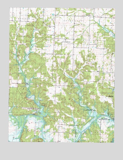
Monegaw Springs, MO USGS Topographic Map
Click on map above to begin viewing in our Map Viewer.

This topographic map contains these locations and features:
Feature Name Type Latitude Longitude GNIS ID View Map
Benton Green CemeteryCemeteryN38.0142°W93.8169°755753View Map
Benton Green School (historical)SchoolN38.0095°W93.8127°755754View Map
Chalk LevelPopulated PlaceN38.0934°W93.8097°755874View Map
Chalk Level Church (historical)ChurchN38.0967°W93.8088°755875View Map
Chalk Level School (historical)SchoolN38.0847°W93.8131°755876View Map
Clubhouse HillSummitN38.0353°W93.8344°758186View Map
Concord ChurchChurchN38.1186°W93.7827°755915View Map
Cooks ChapelChurchN38.0661°W93.7697°755921View Map
Finley CreekStreamN38.0717°W93.8630°756050View Map
Kibbie HillSummitN38.0514°W93.8416°758185View Map
Kidds ChapelChurchN38.1078°W93.8294°756247View Map
Lewellan School (historical)SchoolN38.1203°W93.8624°756291View Map
Lewis School (historical)SchoolN38.0575°W93.7533°756294View Map
Lewis School (historical)SchoolN38.0731°W93.7542°756295View Map
Little Monegaw CreekStreamN38.0231°W93.8349°756311View Map
Magnolia SpringSpringN38.0328°W93.7827°756340View Map
Mills Lake DamDamN38.0517°W93.7969°763492View Map
Monegaw CreekStreamN38.0203°W93.8555°756405View Map
Monegaw School (historical)SchoolN38.0320°W93.8438°757198View Map
Monegaw SpringsPopulated PlaceN38.0292°W93.8391°756406View Map
Motley CemeteryCemeteryN38.0509°W93.8149°756413View Map
Motley School (historical)SchoolN38.0420°W93.8216°756414View Map
Number 565 DamDamN38.1150°W93.8152°764573View Map
Parks CemeteryCemeteryN38.0797°W93.8649°758184View Map
Parks School (historical)SchoolN38.0798°W93.8633°756504View Map
Pleasant Valley School (historical)SchoolN38.1172°W93.7976°756541View Map
Reader HillSummitN38.0000°W93.8399°756570View Map
Red Rock School (historical)SchoolN38.0336°W93.7699°756572View Map
Saint Clair CountyCivilN38.0372°W93.7760°758547View Map
Salt CreekStreamN38.0234°W93.7702°756686View Map
Shady Grove Church (historical)ChurchN38.0864°W93.8616°756704View Map
Silver CreekStreamN38.0353°W93.7908°756720View Map
Spill CreekStreamN38.1034°W93.8463°756751View Map
Spring LakeReservoirN38.0189°W93.8350°756757View Map
Terry CemeteryCemeteryN38.1161°W93.8480°756790View Map
Thomas CemeteryCemeteryN38.0172°W93.7924°758187View Map
Township of CenterCivilN38.0512°W93.8026°767310View Map
Upps Resort Lake DamDamN38.0250°W93.7602°763491View Map
Washington School (historical)SchoolN38.0395°W93.8749°756870View Map
Wixted AirportAirportN38.0417°W93.7835°758842View Map
Yeater CemeteryCemeteryN38.0697°W93.7677°756934View Map
Yellow CreekStreamN38.0095°W93.7891°756936View Map
Youngers LookoutLocaleN38.0256°W93.8438°756938View Map

Note: Coordinates in the location and feature list above are referenced to NAD83 datum.


Copyright (C) 2008-2024 Ryan Niemi / Sunset Dynamics ... All Rights Reserved