TopoQuest Logo
Do you find TopoQuest useful?
Help keep TopoQuest running and adding new maps/features by donating!
Bitcoin:  19c7KJd3qBynnjoSw5npx9KScwjBe4ifkT
Litecoin:  LXs6TkuXGGXo1vDsWCkWVdjQX94eUKd6ui
Home View Maps Find Maps Find Places Resources & Links


Molunkus Lake, Maine Topographic Map

USGS Map Title: Molunkus Lake, ME
USGS Map MRC: 45068F3
DRG (GeoTIFF) Download: o45068f3.tif


Neighboring USGS Topographic Map Quads:


  Benedicta, ME  
45068G4
 

  Monarda, ME  
45068G3
 

  Wytopitlock Lake, ME  
45068G2
 

  Salmon Stream Lake, ME  
45068F4
 

  Molunkus Lake, ME  
45068F3
 

  Reed Pond, ME  
45068F2
 

  Mattaseunk Lake, ME  
45068E4
 

  Mattawamkeag, ME  
45068E3
 

  Kingman, ME  
45068E2


Map MRC Location:

N46°
W69°
N46°
W68°
H8 H7 H6 H5 H4 H3 H2 H1
G8 G7 G6 G5 G4 G3 G2 G1
F8 F7 F6 F5 F4 F3 F2 F1
E8 E7 E6 E5 E4 E3 E2 E1
D8 D7 D6 D5 D4 D3 D2 D1
C8 C7 C6 C5 C4 C3 C2 C1
B8 B7 B6 B5 B4 B3 B2 B1
A8 A7 A6 A5 A4 A3 A2 A1
N45°
W69°
N45°
W68°

Molunkus Lake, ME USGS 1:24K Topographic Map Preview:
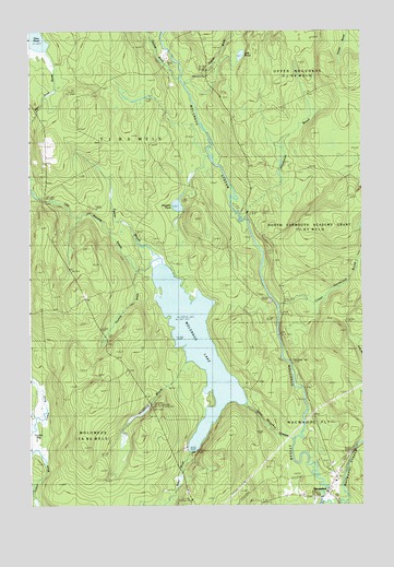
Molunkus Lake, ME USGS Topographic Map
Click on map above to begin viewing in our Map Viewer.

This topographic map contains these locations and features:
Feature Name Type Latitude Longitude GNIS ID View Map
Baker BrookStreamN45.6395°W68.3142°581513View Map
Carlton BogSwampN45.6434°W68.3703°581516View Map
Fourmile BrookStreamN45.6837°W68.3272°581524View Map
Fowler BrookStreamN45.6906°W68.3256°581526View Map
Gulliver BrookStreamN45.7364°W68.3153°581529View Map
Haywire PondLakeN45.7040°W68.3192°581530View Map
Henderson BrookStreamN45.7023°W68.2950°581531View Map
Little Molunkus StreamStreamN45.6426°W68.2756°581536View Map
Lost PondLakeN45.7436°W68.2951°581537View Map
Lower Henderson BrookStreamN45.6787°W68.2820°581538View Map
MacwahocPopulated PlaceN45.6284°W68.2628°581539View Map
Macwahoc StreamStreamN45.6259°W68.2647°581540View Map
Molunkus LakeLakeN45.6674°W68.3124°581542View Map
Molunkus TownshipCivilN45.6268°W68.3660°2748749View Map
Pine Tree TrailTrailN45.6270°W68.2809°581547View Map
Plunkett BrookStreamN45.7376°W68.3175°581548View Map
Smith CemeteryCemeteryN45.6330°W68.2618°2678677View Map
T1 R5 WELSCivilN45.7193°W68.3653°1987144View Map
Threemile BrookStreamN45.6634°W68.3153°581553View Map
Village CemeteryCemeteryN45.6270°W68.2682°2678678View Map

Note: Coordinates in the location and feature list above are referenced to NAD83 datum.


Copyright (C) 2008-2024 Ryan Niemi / Sunset Dynamics ... All Rights Reserved