TopoQuest Logo
Do you find TopoQuest useful?
Help keep TopoQuest running and adding new maps/features by donating!
Bitcoin:  19c7KJd3qBynnjoSw5npx9KScwjBe4ifkT
Litecoin:  LXs6TkuXGGXo1vDsWCkWVdjQX94eUKd6ui
Home View Maps Find Maps Find Places Resources & Links


Mitchell, South Dakota Topographic Map

USGS Map Title: Mitchell, SD
USGS Map MRC: 43098F1
DRG (GeoTIFF) Download: o43098f1.tif


Neighboring USGS Topographic Map Quads:


  Letcher SW, SD  
43098G2
 

  Loomis, SD  
43098G1
 

  Farwell, SD  
43097G8
 

  Betts, SD  
43098F2
 

  Mitchell, SD  
43098F1
 

  Riverside, SD  
43097F8
 

  Mitchell SW, SD  
43098E2
 

  Shoemaker Dam, SD  
43098E1
 

  Ethan, SD  
43097E8


Map MRC Location:

N44°
W99°
N44°
W98°
H8 H7 H6 H5 H4 H3 H2 H1
G8 G7 G6 G5 G4 G3 G2 G1
F8 F7 F6 F5 F4 F3 F2 F1
E8 E7 E6 E5 E4 E3 E2 E1
D8 D7 D6 D5 D4 D3 D2 D1
C8 C7 C6 C5 C4 C3 C2 C1
B8 B7 B6 B5 B4 B3 B2 B1
A8 A7 A6 A5 A4 A3 A2 A1
N43°
W99°
N43°
W98°

Mitchell, SD USGS 1:24K Topographic Map Preview:
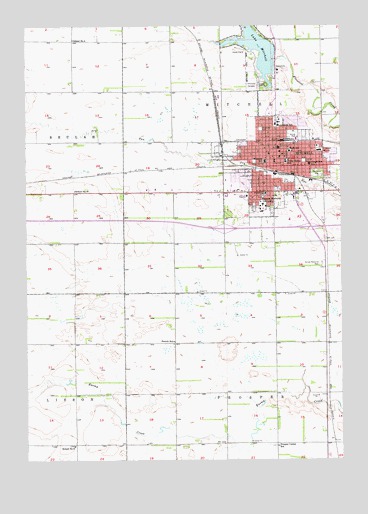
Mitchell, SD USGS Topographic Map
Click on map above to begin viewing in our Map Viewer.

This topographic map contains these locations and features:
Feature Name Type Latitude Longitude GNIS ID View Map
Allen HallBuildingN43.6974°W98.0302°2726210View Map
American Legion CemeteryCemeteryN43.7316°W98.0336°2773634View Map
Avera Queen of Peace HospitalHospitalN43.7144°W98.0083°2610935View Map
Cadwell ParkParkN43.7219°W98.0370°2726211View Map
Cadwell Park StadiumLocaleN43.7220°W98.0359°2726247View Map
Calvary CemeteryCemeteryN43.7332°W98.0326°1254195View Map
Christen Family Recreation/Wellness CenterBuildingN43.6961°W98.0306°2726212View Map
City of MitchellCivilN43.7294°W98.0336°1267480View Map
Corn PalaceBuildingN43.7147°W98.0251°1254463View Map
Dakota Discovery MuseumBuildingN43.6978°W98.0293°2726213View Map
Dakota Wesleyan UniversitySchoolN43.6986°W98.0315°1254591View Map
Davison County CourthouseBuildingN43.7130°W98.0235°2712632View Map
Davison County JailBuildingN43.7003°W98.0379°2755655View Map
Davison County Sheriff's OfficeBuildingN43.7003°W98.0379°2755472View Map
Davison County Volunteer Search and RescueBuildingN43.7143°W98.0428°2658957View Map
Dayton HallBuildingN43.6971°W98.0323°2726214View Map
Drake FieldLocaleN43.7229°W98.0370°2726248View Map
Eastside ParkParkN43.7108°W98.0151°1254872View Map
Field SchoolSchoolN43.7017°W98.0304°1255040View Map
French SchoolSchoolN43.6592°W98.0667°1255162View Map
Gertie Belle Rogers Elementary SchoolSchoolN43.7220°W98.0240°2729092View Map
Glenda K Corrigan Health Sciences CenterSchoolN43.6963°W98.0297°2726249View Map
Graceland CemeteryCemeteryN43.7328°W98.0353°1255315View Map
Hitchcock ParkParkN43.7072°W98.0095°1255590View Map
Hughes Science HallSchoolN43.6981°W98.0323°2726215View Map
Interchange 330CrossingN43.6915°W98.0468°2725907View Map
Interchange 332CrossingN43.6919°W98.0120°2725909View Map
Joe Quintal FieldLocaleN43.7191°W98.0191°2726216View Map
John Paul II Elementary SchoolSchoolN43.7039°W98.0443°2728872View Map
Kargas SubdivisionPopulated PlaceN43.6930°W98.0295°1264357View Map
Ketnel ParkParkN43.7189°W98.0192°1255928View Map
KMIT-FM (Mitchell)TowerN43.6961°W98.0601°1263218View Map
KMIT-FM (Mitchell)TowerN43.6903°W98.0079°1259266View Map
L B Williams Elementary SchoolSchoolN43.6958°W98.0318°2729093View Map
Litchfield SchoolSchoolN43.7214°W98.0254°1256149View Map
Longfellow Elementary SchoolSchoolN43.7101°W98.0136°1256240View Map
McGovern LibraryBuildingN43.6985°W98.0304°2723622View Map
MitchellPopulated PlaceN43.7094°W98.0298°1256500View Map
Mitchell Christian Elementary SchoolSchoolN43.7265°W98.0367°2729099View Map
Mitchell Christian High SchoolSchoolN43.7265°W98.0367°2729100View Map
Mitchell Christian Junior High SchoolSchoolN43.7265°W98.0367°2729101View Map
Mitchell City HallBuildingN43.7151°W98.0253°2725155View Map
Mitchell DamDamN43.7403°W98.0267°1260094View Map
Mitchell Department of Public Safety Police DivisionBuildingN43.7091°W98.0271°2755469View Map
Mitchell Fire and Emergency Medical ServicesBuildingN43.7091°W98.0273°2580702View Map
Mitchell High SchoolSchoolN43.7182°W98.0164°2729095View Map
Mitchell Middle SchoolSchoolN43.7183°W98.0358°2729094View Map
Mitchell Post OfficePost OfficeN43.7138°W98.0274°2710592View Map
Mitchell Public LibraryBuildingN43.7113°W98.0288°2723623View Map
Mitchell Technical Institute - North CampusSchoolN43.7174°W98.0180°2726095View Map
Mitchell Technical Institute - South CampusSchoolN43.6894°W98.0041°2726094View Map
Mitchell Technical Institute LibraryBuildingN43.7174°W98.0180°2723624View Map
Northside ParkParkN43.7203°W98.0320°1256793View Map
Notre Dame SchoolSchoolN43.7108°W98.0220°1256804View Map
Parker United Methodist Conference CenterBuildingN43.6970°W98.0331°2726239View Map
Patten-Wing TheatreBuildingN43.6981°W98.0323°2726240View Map
Prather HallBuildingN43.6993°W98.0320°2726241View Map
Prosper Center SchoolSchoolN43.6289°W98.0256°1257237View Map
River Bluff AdditionPopulated PlaceN43.7333°W98.0656°1264359View Map
Rollins Campus CenterBuildingN43.6977°W98.0312°2726242View Map
Saint Joseph HospitalHospitalN43.7139°W98.0087°1257642View Map
Sand Hill SubdivisionPopulated PlaceN43.7028°W98.0462°1264358View Map
School Number 27SchoolN43.7025°W98.1059°1257903View Map
School Number 5SchoolN43.7458°W98.1062°1257946View Map
School Number 8SchoolN43.6292°W98.1065°1257970View Map
Sherman CenterChurchN43.6976°W98.0312°2726243View Map
Smith HallSchoolN43.6984°W98.0313°2726244View Map
Sunset Memorial ParkCemeteryN43.6811°W98.0081°1258438View Map
Super City MallLocaleN43.7280°W98.0279°1259539View Map
Telstar Landing Field (historical)AirportN43.6983°W98.0215°1259800View Map
Township of MitchellCivilN43.7417°W98.0337°1268959View Map
Township of ProsperCivilN43.6296°W98.0264°1268958View Map
Unorganized Territory of MitchellCivilN43.6802°W98.0265°2393300View Map
Wagner ChapelChurchN43.6974°W98.0312°2726245View Map
Westside ParkParkN43.7108°W98.0345°1258930View Map
Whittier SchoolSchoolN43.7108°W98.0304°1258990View Map

Note: Coordinates in the location and feature list above are referenced to NAD83 datum.


Copyright (C) 2008-2024 Ryan Niemi / Sunset Dynamics ... All Rights Reserved