TopoQuest Logo
Do you find TopoQuest useful?
Help keep TopoQuest running and adding new maps/features by donating!
Bitcoin:  19c7KJd3qBynnjoSw5npx9KScwjBe4ifkT
Litecoin:  LXs6TkuXGGXo1vDsWCkWVdjQX94eUKd6ui
Home View Maps Find Maps Find Places Resources & Links


Miston, Tennessee Topographic Map

USGS Map Title: Miston, TN
USGS Map MRC: 36089B4
DRG (GeoTIFF) Download: o36089b4.tif


Neighboring USGS Topographic Map Quads:


  Mooring, TN  
36089C5
 

  Ridgely, TN  
36089C4
 

  Hornbeak, TN  
36089C3
 

  Tennemo, TN  
36089B5
 

  Miston, TN  
36089B4
 

  Lane, TN  
36089B3
 

  Caruthersville SE, TN  
36089A5
 

  Dyersburg, TN  
36089A4
 

  Newbern, TN  
36089A3


Map MRC Location:

N37°
W90°
N37°
W89°
H8 H7 H6 H5 H4 H3 H2 H1
G8 G7 G6 G5 G4 G3 G2 G1
F8 F7 F6 F5 F4 F3 F2 F1
E8 E7 E6 E5 E4 E3 E2 E1
D8 D7 D6 D5 D4 D3 D2 D1
C8 C7 C6 C5 C4 C3 C2 C1
B8 B7 B6 B5 B4 B3 B2 B1
A8 A7 A6 A5 A4 A3 A2 A1
N36°
W90°
N36°
W89°

Miston, TN USGS 1:24K Topographic Map Preview:
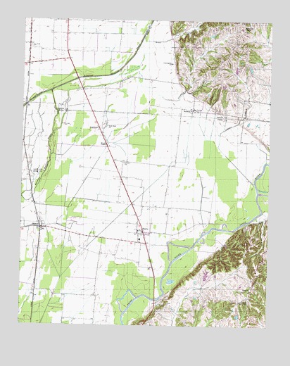
Miston, TN USGS Topographic Map
Click on map above to begin viewing in our Map Viewer.

This topographic map contains these locations and features:
Feature Name Type Latitude Longitude GNIS ID View Map
Bledsoe CemeteryCemeteryN36.1334°W89.4262°1277680View Map
BogotaPopulated PlaceN36.1640°W89.4384°1277877View Map
Bogota Baptist ChurchChurchN36.1631°W89.4384°1643389View Map
Bogota Elementary SchoolSchoolN36.1603°W89.4401°1309777View Map
Bogota Post OfficePost OfficeN36.1625°W89.4375°1650091View Map
Bogota Volunteer Fire DepartmentBuildingN36.1608°W89.4403°2653693View Map
Booger Den HollowValleyN36.2202°W89.4155°1647539View Map
BroadmoorPopulated PlaceN36.2056°W89.4612°1278434View Map
Brown CreekStreamN36.2434°W89.4395°1278574View Map
Bruces ChapelChurchN36.1995°W89.4573°1278661View Map
Bryants ChapelChurchN36.1353°W89.3881°1278758View Map
CalvaryPopulated PlaceN36.1923°W89.4492°1647225View Map
Calvary ChurchChurchN36.1917°W89.4487°1305611View Map
Cat CornerPopulated PlaceN36.2137°W89.4142°1279865View Map
Commissioner District 4CivilN36.1557°W89.4074°2464031View Map
CunninghamPopulated PlaceN36.2334°W89.4240°1326717View Map
Cunningham ChurchChurchN36.2323°W89.4240°1326889View Map
Cunningham SchoolSchoolN36.2323°W89.4251°1281874View Map
Daugherty CreekStreamN36.2195°W89.4320°1282077View Map
District 16 (historical)CivilN36.1778°W89.4334°1310268View Map
Horn Ridge CemeteryCemeteryN36.2392°W89.4965°1288359View Map
Hornridge Methodist Church (historical)ChurchN36.2381°W89.4965°1319179View Map
Inman HollowValleyN36.2429°W89.4251°1289026View Map
Johnson CreekStreamN36.1823°W89.3815°1289599View Map
MillsfieldPopulated PlaceN36.1415°W89.3826°1293998View Map
Millsfield School (historical)SchoolN36.1401°W89.3842°1316133View Map
Millsfield Volunteer Fire DepartmentBuildingN36.1393°W89.3840°2653783View Map
MistonPopulated PlaceN36.1648°W89.4904°1294089View Map
Miston Baptist ChurchChurchN36.1648°W89.4892°1643407View Map
Miston Post OfficePost OfficeN36.1648°W89.4898°1650106View Map
Rehoboth ChurchChurchN36.2134°W89.4145°1299202View Map
Rolling Acres Lake DamDamN36.1417°W89.4067°1302387View Map
Rolling Acres ReservoirReservoirN36.1417°W89.4067°1302388View Map
Solid Rock ChurchChurchN36.2067°W89.4573°1270802View Map
United States Forest Service Tennessee Forestry DivisionBuildingN36.1431°W89.3827°2654207View Map
Woodward ChapelChurchN36.2473°W89.3887°1275105View Map

Note: Coordinates in the location and feature list above are referenced to NAD83 datum.


Copyright (C) 2008-2024 Ryan Niemi / Sunset Dynamics ... All Rights Reserved