TopoQuest Logo
Do you find TopoQuest useful?
Help keep TopoQuest running and adding new maps/features by donating!
Bitcoin:  19c7KJd3qBynnjoSw5npx9KScwjBe4ifkT
Litecoin:  LXs6TkuXGGXo1vDsWCkWVdjQX94eUKd6ui
Home View Maps Find Maps Find Places Resources & Links


Minnehaha Springs, West Virginia Topographic Map

USGS Map Title: Minnehaha Springs, WV
USGS Map MRC: 38079B8
DRG (GeoTIFF) Download: o38079b8.tif


Neighboring USGS Topographic Map Quads:


  Edray, WV  
38080C1
 

  Clover Lick, WV  
38079C8
 

  Paddy Knob, WV  
38079C7
 

  Marlinton, WV  
38080B1
 

  Minnehaha Springs, WV  
38079B8
 

  Sunrise, VA  
38079B7
 

  Lake Sherwood, WV  
38080A1
 

  Mountain Grove, VA  
38079A8
 

  Warm Springs, VA  
38079A7


Map MRC Location:

N39°
W80°
N39°
W79°
H8 H7 H6 H5 H4 H3 H2 H1
G8 G7 G6 G5 G4 G3 G2 G1
F8 F7 F6 F5 F4 F3 F2 F1
E8 E7 E6 E5 E4 E3 E2 E1
D8 D7 D6 D5 D4 D3 D2 D1
C8 C7 C6 C5 C4 C3 C2 C1
B8 B7 B6 B5 B4 B3 B2 B1
A8 A7 A6 A5 A4 A3 A2 A1
N38°
W80°
N38°
W79°

Minnehaha Springs, WV USGS 1:24K Topographic Map Preview:
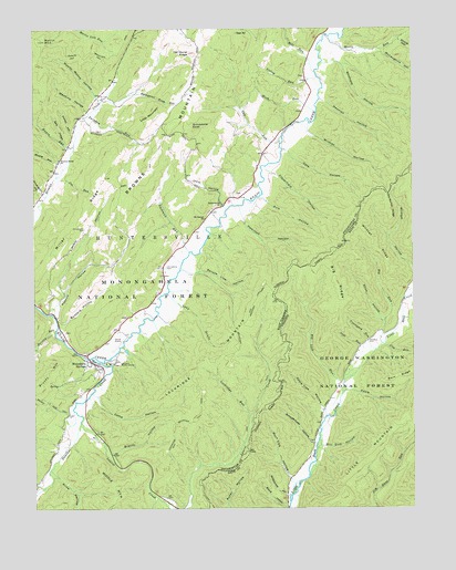
Minnehaha Springs, WV USGS Topographic Map
Click on map above to begin viewing in our Map Viewer.

This topographic map contains these locations and features:
Feature Name Type Latitude Longitude GNIS ID View Map
Alex RunStreamN38.1676°W79.8851°1481273View Map
Apple Tree HollowValleyN38.1505°W79.9047°1481333View Map
Barclay RunStreamN38.1715°W79.9928°1550168View Map
Barn RidgeRidgeN38.1593°W79.8803°1481463View Map
Big Lick RunStreamN38.1573°W79.8981°1481753View Map
Big RidgeRidgeN38.1840°W79.9001°1481770View Map
Big RunStreamN38.1679°W79.8851°1481776View Map
Board HollowValleyN38.1250°W79.9170°1481888View Map
Brandy HollowValleyN38.1393°W79.9737°1550443View Map
Browns Creek ChurchChurchN38.2160°W79.9912°1550487View Map
Browns Creek School (historical)SchoolN38.2160°W79.9912°1728010View Map
Browns MountainSummitN38.2112°W79.9637°1553993View Map
Brushy Mountain TrailTrailN38.1529°W79.9951°1550512View Map
Buck Lick HollowValleyN38.1328°W79.9157°1482113View Map
Buzzard HollowValleyN38.1735°W79.9906°1550575View Map
Camp HollowValleyN38.1535°W79.9787°1550603View Map
Camp MinnehahaLocaleN38.1629°W79.9709°1550607View Map
Chestnut CemeteryCemeteryN38.1684°W79.8901°1482468View Map
Cloverfield HollowValleyN38.2121°W79.9203°1550732View Map
Cochran CreekStreamN38.1268°W79.9578°1550750View Map
Davis HollowValleyN38.1559°W79.8959°1482947View Map
Davis SpringSpringN38.1715°W79.9737°1558085View Map
Dourif Airport (historical)AirportN38.1685°W79.9728°1553601View Map
Douthat CreekStreamN38.1646°W79.9812°1550947View Map
Douthat Creek School (historical)SchoolN38.1465°W79.9914°1728044View Map
Evic HollowValleyN38.2048°W79.9228°1551071View Map
Gate HollowValleyN38.2173°W79.9153°1551209View Map
Gill Gum HollowValleyN38.1411°W79.9043°1483624View Map
Graveyard RunStreamN38.1665°W79.8873°1483770View Map
Grindstone KnobSummitN38.2240°W79.9467°1551306View Map
Guy RunStreamN38.2201°W79.9184°1551315View Map
Guy Run SpringSpringN38.2196°W79.9220°1558102View Map
Hamilton HollowValleyN38.2001°W79.9306°1551334View Map
Huntersville DistrictCivilN38.2004°W79.9736°1928291View Map
Irvin HollowValleyN38.2040°W79.9378°1551547View Map
Jim RunStreamN38.2118°W79.9923°1551572View Map
Kline HollowValleyN38.1335°W79.9926°1551660View Map
Knave RunStreamN38.2196°W79.9867°1551664View Map
Laurel CreekStreamN38.1476°W79.9848°1551704View Map
Laurel Creek Hiking TrailTrailN38.1368°W79.9312°1553604View Map
Little MountainSummitN38.2279°W79.9595°1554967View Map
Lockridge MountainSummitN38.1832°W79.9242°1554983View Map
Lockridge Mountain TrailTrailN38.1579°W79.9470°1551908View Map
Lockridge RunStreamN38.1490°W79.9292°1551909View Map
Lucy DraftValleyN38.1773°W79.9506°1551966View Map
Machine HollowValleyN38.2290°W79.9826°1551982View Map
Mash RunStreamN38.2282°W79.9064°1552010View Map
McCarty SpringSpringN38.2348°W79.9664°1558125View Map
McLaughlin CemeteryCemeteryN38.1982°W79.9831°1552037View Map
McLaughlin HollowValleyN38.2076°W79.9973°1552038View Map
McLaughlin HollowValleyN38.2437°W79.8845°1552039View Map
Mill RunStreamN38.2387°W79.9067°1552129View Map
Mill Run SpringSpringN38.2432°W79.9095°1558134View Map
Miller RidgeRidgeN38.2010°W79.9837°1552143View Map
Minnehaha SpringSpringN38.1640°W79.9745°1558135View Map
Minnehaha SpringsPopulated PlaceN38.1632°W79.9809°1552164View Map
Minnehaha Springs Post OfficePost OfficeN38.1629°W79.9806°1728115View Map
Moody Moore HollowValleyN38.2323°W79.9792°1552175View Map
Moore HollowValleyN38.2151°W79.9926°1552178View Map
Moore RunStreamN38.2479°W79.9020°1552179View Map
Moore School (historical)SchoolN38.2287°W79.9112°1728117View Map
Mount Carmel ChurchChurchN38.2004°W79.9434°1552195View Map
Mount Tabor School (historical)SchoolN38.2285°W79.9545°1728125View Map
Newman HollowValleyN38.2310°W79.9031°1552306View Map
Old Hump RidgeRidgeN38.2040°W79.8826°1485958View Map
Pickett HollowValleyN38.2235°W79.9873°1552470View Map
Possum HollowValleyN38.1790°W79.9914°1552545View Map
Rainbow RunStreamN38.2276°W79.9820°1552579View Map
Rattlesnake HollowValleyN38.1285°W79.9169°1486515View Map
Rimel Parking CicleLocaleN38.1279°W79.9576°1553603View Map
Road RunStreamN38.2037°W79.9981°1552680View Map
Ruckman RunStreamN38.1921°W79.9487°1552753View Map
Ruckman Run SpringSpringN38.1932°W79.9498°1558147View Map
Sally HollowValleyN38.2207°W79.9898°1552776View Map
Sampson Pike HollowValleyN38.2312°W79.9748°1552785View Map
Schoolhouse HollowValleyN38.1329°W79.9981°1552815View Map
Schoolhouse HollowValleyN38.1422°W79.9079°1486965View Map
See AllSummitN38.2487°W79.9328°1555588View Map
Seneca Lake DamDamN38.2218°W79.9148°1559224View Map
Sharp HollowValleyN38.1404°W79.9934°1552844View Map
Sharp HollowValleyN38.2471°W79.8789°1552845View Map
Shinaberry CemeteryCemeteryN38.1879°W79.9562°1552867View Map
Shop HollowValleyN38.1735°W79.8845°1487212View Map
Shumate HollowValleyN38.2410°W79.8981°1552890View Map
Spruce Lick HollowValleyN38.1865°W79.9462°1553017View Map
Still RunStreamN38.1598°W79.8973°1487575View Map
Sunset (historical)Populated PlaceN38.2001°W79.9442°1728170View Map
Sunset School (historical)SchoolN38.1982°W79.9456°1728172View Map
The Horse RidgeSummitN38.2435°W79.9473°1555799View Map
Valley DraftValleyN38.2368°W79.9098°1728185View Map
Valley RunStreamN38.2373°W79.9059°1553338View Map
Westminster Presbyterian ChurchChurchN38.2043°W79.9376°1553410View Map
Wildcat HollowValleyN38.2226°W79.9081°1553447View Map
Wildcat RidgeRidgeN38.1932°W79.8867°1488375View Map

Note: Coordinates in the location and feature list above are referenced to NAD83 datum.


Copyright (C) 2008-2024 Ryan Niemi / Sunset Dynamics ... All Rights Reserved