TopoQuest Logo
Do you find TopoQuest useful?
Help keep TopoQuest running and adding new maps/features by donating!
Bitcoin:  19c7KJd3qBynnjoSw5npx9KScwjBe4ifkT
Litecoin:  LXs6TkuXGGXo1vDsWCkWVdjQX94eUKd6ui
Home View Maps Find Maps Find Places Resources & Links


Milton South, Florida Topographic Map

USGS Map Title: Milton South, FL
USGS Map MRC: 30087E1
DRG (GeoTIFF) Download: o30087e1.tif


Neighboring USGS Topographic Map Quads:


  Wallace, FL  
30087F2
 

  Milton North, FL  
30087F1
 

  Harold, FL  
30086F8
 

  Pace, FL  
30087E2
 

  Milton South, FL  
30087E1
 

  Ward Basin, FL  
30086E8
 

  Pensacola, FL  
30087D2
 

  Garcon Point, FL  
30087D1
 

  Holley, FL  
30086D8


Map MRC Location:

N31°
W88°
N31°
W87°
H8 H7 H6 H5 H4 H3 H2 H1
G8 G7 G6 G5 G4 G3 G2 G1
F8 F7 F6 F5 F4 F3 F2 F1
E8 E7 E6 E5 E4 E3 E2 E1
D8 D7 D6 D5 D4 D3 D2 D1
C8 C7 C6 C5 C4 C3 C2 C1
B8 B7 B6 B5 B4 B3 B2 B1
A8 A7 A6 A5 A4 A3 A2 A1
N30°
W88°
N30°
W87°

Milton South, FL USGS 1:24K Topographic Map Preview:
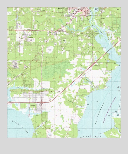
Milton South, FL USGS Topographic Map
Click on map above to begin viewing in our Map Viewer.

This topographic map contains these locations and features:
Feature Name Type Latitude Longitude GNIS ID View Map
A J Spencer PondLakeN30.6139°W87.1148°298128View Map
Albert Gordon PondLakeN30.5532°W87.0392°298127View Map
Avalon BeachPopulated PlaceN30.5302°W87.1016°295103View Map
Avalon Beach Mulat Volunteer Fire Department 12BuildingN30.5736°W87.0983°2644132View Map
Avalon Census Designated PlaceCensusN30.5366°W87.1008°2629553View Map
Avalon Mulat Census Designated PlaceCensusN30.5326°W87.0936°2583325View Map
Avalon-Mulat DivisionCivilN30.5052°W87.1089°2648019View Map
BagdadPopulated PlaceN30.5988°W87.0311°278027View Map
Bagdad Census Designated PlaceCensusN30.5824°W87.0447°2402659View Map
Bagdad DivisionCivilN30.5119°W87.0441°2648020View Map
Bagdad Elementary SchoolSchoolN30.5985°W87.0294°298891View Map
Bagdad Naval Outer Landing Field (historical)MilitaryN30.5847°W87.0786°2105214View Map
Bagdad Post OfficePost OfficeN30.6032°W87.0342°2759153View Map
Bagdad Volunteer Fire DepartmentBuildingN30.5970°W87.0297°2644151View Map
Bay PointCapeN30.5694°W87.0019°278224View Map
Bethel ChurchChurchN30.6021°W87.0647°278546View Map
Blackwater BayBayN30.5422°W87.0148°278964View Map
Blackwater RiverStreamN30.5738°W87.0011°309999View Map
Central ChurchChurchN30.6163°W87.0561°280254View Map
Doghole BasinBayN30.5254°W87.0057°281660View Map
Eagle PointCapeN30.5313°W87.0369°281930View Map
East MiltonPopulated PlaceN30.6152°W87.0216°282001View Map
East Milton Elementary SchoolSchoolN30.6232°W87.0200°298889View Map
East Milton Fire and Rescue Department 15BuildingN30.6191°W87.0218°2644299View Map
East Side ChurchChurchN30.6107°W87.0208°282030View Map
Edwards ChurchChurchN30.5571°W87.1172°282107View Map
Escribano PointCapeN30.5041°W87.0211°282252View Map
Eternal Trinity ChurchChurchN30.6021°W87.0697°282264View Map
Fundy BayouStreamN30.5113°W87.0075°282856View Map
Galilee ChurchChurchN30.6013°W87.0764°282883View Map
Galilee ChurchChurchN30.6227°W87.0208°282884View Map
Galt CityPopulated PlaceN30.5894°W87.0580°295308View Map
Glad Tidings ChurchChurchN30.6032°W87.1230°283098View Map
Grassy PointCapeN30.5216°W87.0111°283336View Map
HarpPopulated PlaceN30.5605°W87.1080°294796View Map
Indian BayouStreamN30.5219°W87.1052°284483View Map
Jackson SchoolSchoolN30.6144°W87.0422°284688View Map
Jakes BayouStreamN30.5449°W87.0277°284711View Map
Lifeguard Ambulance of Florida HeadquartersBuildingN30.5929°W87.0820°2661718View Map
Little Catfish BasinBayN30.5222°W87.0033°285634View Map
Magnolia CemeteryCemeteryN30.6227°W87.0047°286291View Map
Marquis BasinLakeN30.6232°W87.0270°286445View Map
Mayo ParkParkN30.6055°W87.0605°286551View Map
Milton Cemetery Sect 2CemeteryN30.6229°W87.0488°286949View Map
Milton Post OfficePost OfficeN30.6204°W87.0566°2759175View Map
Mount Bethel ChurchChurchN30.5969°W87.0341°287203View Map
MulatPopulated PlaceN30.5513°W87.1233°295471View Map
Mulat Lookout TowerTowerN30.5691°W87.1016°301632View Map
Mulatto BayouBayN30.5472°W87.1197°287438View Map
Pace Middle SchoolSchoolN30.5705°W87.0965°298897View Map
Pace Volunteer Fire Department Substation 3BuildingN30.6025°W87.0983°2644333View Map
Parkmore MallLocaleN30.6196°W87.0558°295829View Map
Pea RidgeRidgeN30.5991°W87.1183°288602View Map
Pea Ridge Census Designated PlaceCensusN30.6029°W87.1022°2629561View Map
Pea Ridge ChurchChurchN30.5955°W87.1105°288603View Map
Pea Ridge Elementary SchoolSchoolN30.6087°W87.1120°298893View Map
Pelican BayouStreamN30.6024°W87.0175°288668View Map
Pensacola Community CollegeSchoolN30.6191°W87.0383°288704View Map
Pensacola State College Police Department - Milton CampusBuildingN30.6050°W87.0754°2754535View Map
Pond CreekStreamN30.6060°W87.0314°289182View Map
Robinson PointCapeN30.5480°W87.0147°289800View Map
Sandy Point BayouStreamN30.5605°W87.0102°290628View Map
Shields PointCapeN30.5802°W87.0125°291023View Map
Strickland CemeteryCemeteryN30.6020°W87.0895°291750View Map
Trout BayouStreamN30.5063°W87.0952°292460View Map
W H Rhodes Elementary SchoolSchoolN30.6241°W87.0402°298890View Map
Weaver RiverStreamN30.5374°W87.0022°292967View Map
WEBY-AM (Milton)TowerN30.6202°W87.0225°308790View Map
WEGS-FM (Milton)TowerN30.6249°W87.0855°309072View Map
West Milton ChurchChurchN30.6030°W87.1025°293095View Map
Whiteoak BayouStreamN30.5349°W87.0375°293243View Map
Wilson Memorial ChurchChurchN30.5824°W87.0350°293382View Map
WTKX-FM (Pensacola)TowerN30.6249°W87.0855°309102View Map
Yellow River Marsh Aquatic PreserveParkN30.5419°W87.0005°304100View Map

Note: Coordinates in the location and feature list above are referenced to NAD83 datum.


Copyright (C) 2008-2024 Ryan Niemi / Sunset Dynamics ... All Rights Reserved