TopoQuest Logo
Do you find TopoQuest useful?
Help keep TopoQuest running and adding new maps/features by donating!
Bitcoin:  19c7KJd3qBynnjoSw5npx9KScwjBe4ifkT
Litecoin:  LXs6TkuXGGXo1vDsWCkWVdjQX94eUKd6ui
Home View Maps Find Maps Find Places Resources & Links


Milledgeville, Tennessee Topographic Map

USGS Map Title: Milledgeville, TN
USGS Map MRC: 35088C3
DRG (GeoTIFF) Download: o35088c3.tif


Neighboring USGS Topographic Map Quads:


  Enville, TN  
35088D4
 

  Sardis, TN  
35088D3
 

  Thurman, TN  
35088D2
 

  Leapwood, TN  
35088C4
 

  Milledgeville, TN  
35088C3
 

  Hookers Bend, TN  
35088C2
 

  Stantonville, TN  
35088B4
 

  Pittsburg Landing, TN  
35088B3
 

  Savannah, TN  
35088B2


Map MRC Location:

N36°
W89°
N36°
W88°
H8 H7 H6 H5 H4 H3 H2 H1
G8 G7 G6 G5 G4 G3 G2 G1
F8 F7 F6 F5 F4 F3 F2 F1
E8 E7 E6 E5 E4 E3 E2 E1
D8 D7 D6 D5 D4 D3 D2 D1
C8 C7 C6 C5 C4 C3 C2 C1
B8 B7 B6 B5 B4 B3 B2 B1
A8 A7 A6 A5 A4 A3 A2 A1
N35°
W89°
N35°
W88°

Milledgeville, TN USGS 1:24K Topographic Map Preview:
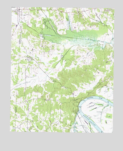
Milledgeville, TN USGS Topographic Map
Click on map above to begin viewing in our Map Viewer.

This topographic map contains these locations and features:
Feature Name Type Latitude Longitude GNIS ID View Map
Amis CemeteryCemeteryN35.3523°W88.3625°1323718View Map
Armstrong LandingLocaleN35.2840°W88.2745°1646314View Map
Bailey BranchStreamN35.2679°W88.2939°1276089View Map
Beason CreekStreamN35.2704°W88.2911°1305034View Map
BethlehemPopulated PlaceN35.2551°W88.3503°1314672View Map
Bethlehem CemeteryCemeteryN35.2501°W88.3531°1277162View Map
Bethlehem School (historical)SchoolN35.2531°W88.3495°1323732View Map
Big Gum PondSwampN35.2787°W88.2676°1277300View Map
Bingham CreekStreamN35.3604°W88.2648°1305249View Map
Bluff LandingLocaleN35.2862°W88.2781°1646315View Map
Box ElderPopulated PlaceN35.2537°W88.3095°1307262View Map
Chalk BluffCliffN35.2815°W88.2898°1280196View Map
Chalk CreekStreamN35.3398°W88.2536°1280197View Map
Clayton BranchStreamN35.3654°W88.2689°1280638View Map
Coffee LandingLocaleN35.2706°W88.2931°1314868View Map
Commissioner District 5CivilN35.3435°W88.2869°2464452View Map
Crooked CreekStreamN35.3365°W88.2759°1281665View Map
Davy BranchStreamN35.3334°W88.2503°1282207View Map
District 12 (historical)CivilN35.3001°W88.3000°1310175View Map
District 16 (historical)CivilN35.2542°W88.3167°1310179View Map
Dodds CemeteryCemeteryN35.2720°W88.2950°1282557View Map
Donohoo CemeteryCemeteryN35.2898°W88.2781°1282640View Map
Edmonds BranchStreamN35.2790°W88.2553°1283533View Map
Flats CreekStreamN35.3440°W88.2514°1303453View Map
Hardin County Fire Department / Emergency Management District 2 North StationBuildingN35.3232°W88.3496°2654090View Map
Hardin SloughStreamN35.2609°W88.2786°1286834View Map
Holley CreekStreamN35.2648°W88.3537°1647699View Map
Hurricane CreekStreamN35.3434°W88.2842°1288805View Map
Hurricane School (historical)SchoolN35.3723°W88.3175°1323836View Map
LebanonPopulated PlaceN35.3701°W88.2939°1290900View Map
Lebanon CemeteryCemeteryN35.3684°W88.2942°1323847View Map
Lebanon Methodist ChurchChurchN35.3717°W88.2950°1323848View Map
Liberty CemeteryCemeteryN35.3126°W88.2834°1291112View Map
Liberty Church (historical)ChurchN35.3117°W88.2834°1323850View Map
Liberty School (historical)SchoolN35.3123°W88.2817°1323852View Map
Middleton CreekStreamN35.3465°W88.3187°1303501View Map
MilledgevillePopulated PlaceN35.3729°W88.3675°1647832View Map
Milledgeville Baptist ChurchChurchN35.3717°W88.3673°1320098View Map
Milledgeville CemeteryCemeteryN35.3726°W88.3709°1308701View Map
Milledgeville Post OfficePost OfficeN35.3727°W88.3647°1649730View Map
Milledgeville Volunteer Fire DepartmentBuildingN35.3748°W88.3692°2653659View Map
Morris ChapelPopulated PlaceN35.3240°W88.3523°1294424View Map
Morris Chapel Baptist ChurchChurchN35.3229°W88.3470°1323866View Map
Morris Chapel CemeteryCemeteryN35.3245°W88.3523°1323867View Map
Morris Chapel Division (historical)CensusN35.2515°W88.3123°1648751View Map
Morris Chapel Post OfficePost OfficeN35.3239°W88.3524°1652259View Map
Morris Chapel SchoolSchoolN35.3231°W88.3495°1323868View Map
Morris Chapel United Methodist ChurchChurchN35.3242°W88.3514°1323869View Map
Mud CreekStreamN35.3406°W88.2584°1294989View Map
Mud Creek CanalCanalN35.3359°W88.3009°1313270View Map
Nelsons Ferry (historical)CrossingN35.2804°W88.2881°1313271View Map
New Zeal ChurchChurchN35.3131°W88.2706°1295665View Map
North Fork Mud CreekStreamN35.3151°W88.3223°1295905View Map
Norwood CemeteryCemeteryN35.2979°W88.2925°1323886View Map
Old Union CemeteryCemeteryN35.2823°W88.3273°1323891View Map
Old Union ChurchChurchN35.2823°W88.3278°1296387View Map
Pickens CemeteryCemeteryN35.3720°W88.2975°1297390View Map
Pisgah Church (historical)ChurchN35.3348°W88.3348°1323908View Map
Pitts CemeteryCemeteryN35.3665°W88.3461°1297759View Map
RightLocaleN35.3017°W88.3217°1299427View Map
Rock SpringSpringN35.2602°W88.3102°1299783View Map
Rock Spring School (historical)SchoolN35.2601°W88.3120°1323920View Map
Salt RiverStreamN35.3226°W88.3150°1300593View Map
Short BranchStreamN35.3726°W88.3387°1270178View Map
SibleyPopulated PlaceN35.3148°W88.2720°1314286View Map
South Fork Mud CreekStreamN35.3151°W88.3225°1270878View Map
Spencer CemeteryCemeteryN35.3578°W88.3195°1323954View Map
Spencer CemeteryCemeteryN35.3631°W88.3214°1323955View Map
Sweeney CemeteryCemeteryN35.2942°W88.3214°1271958View Map
Sycamore School (historical)SchoolN35.2815°W88.3562°1323959View Map
Taylor CemeteryCemeteryN35.2951°W88.3092°1272192View Map
Turnbow CemeteryCemeteryN35.3703°W88.2648°1323963View Map
Tyler BranchStreamN35.2592°W88.2967°1273143View Map
White Oak Creek CanalCanalN35.3465°W88.3206°1313290View Map

Note: Coordinates in the location and feature list above are referenced to NAD83 datum.


Copyright (C) 2008-2024 Ryan Niemi / Sunset Dynamics ... All Rights Reserved