TopoQuest Logo
Do you find TopoQuest useful?
Help keep TopoQuest running and adding new maps/features by donating!
Bitcoin:  19c7KJd3qBynnjoSw5npx9KScwjBe4ifkT
Litecoin:  LXs6TkuXGGXo1vDsWCkWVdjQX94eUKd6ui
Home View Maps Find Maps Find Places Resources & Links


Midland, Kansas Topographic Map

USGS Map Title: Midland, KS
USGS Map MRC: 39095A2
DRG (GeoTIFF) Download: o39095a2.tif


Neighboring USGS Topographic Map Quads:


  Oskaloosa, KS  
39095B3
 

  McLouth, KS  
39095B2
 

  Jarbalo, KS  
39095B1
 

  Williamstown, KS  
39095A3
 

  Midland, KS  
39095A2
 

  Tonganoxie, KS  
39095A1
 

  Lawrence West, KS  
38095H3
 

  Lawrence East, KS  
38095H2
 

  Eudora, KS  
38095H1


Map MRC Location:

N40°
W96°
N40°
W95°
H8 H7 H6 H5 H4 H3 H2 H1
G8 G7 G6 G5 G4 G3 G2 G1
F8 F7 F6 F5 F4 F3 F2 F1
E8 E7 E6 E5 E4 E3 E2 E1
D8 D7 D6 D5 D4 D3 D2 D1
C8 C7 C6 C5 C4 C3 C2 C1
B8 B7 B6 B5 B4 B3 B2 B1
A8 A7 A6 A5 A4 A3 A2 A1
N39°
W96°
N39°
W95°

Midland, KS USGS 1:24K Topographic Map Preview:
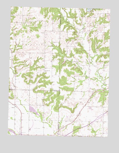
Midland, KS USGS Topographic Map
Click on map above to begin viewing in our Map Viewer.

This topographic map contains these locations and features:
Feature Name Type Latitude Longitude GNIS ID View Map
Hardy Oak CemeteryCemeteryN39.1167°W95.2477°478834View Map
Knowledge Hill SchoolSchoolN39.0628°W95.2058°478831View Map
Lawrence Municipal AirportAirportN39.0068°W95.2166°478829View Map
Leavenworth State Fishing Lake and Wildlife AreaBuildingN39.1239°W95.1474°2503884View Map
Leavenworth State Fishing Lake and Wildlife AreaParkN39.1222°W95.1541°479803View Map
Mackey SchoolSchoolN39.0003°W95.1580°478830View Map
Maple Grove CemeteryCemeteryN39.0019°W95.2319°478828View Map
MidlandPopulated PlaceN39.0283°W95.2422°484869View Map
Mound SchoolSchoolN39.1050°W95.1594°478835View Map
O'Neil SchoolSchoolN39.1000°W95.2069°478833View Map
Pony CreekStreamN39.0547°W95.1358°478836View Map
Prairie Moon Waldorf SchoolSchoolN39.0084°W95.2063°2506375View Map
Reno Township Fire DepartmentBuildingN39.0069°W95.1314°2111769View Map
Sarcoxie Township Fire District 4 South StationBuildingN39.0812°W95.2069°2111839View Map
State LakeReservoirN39.1247°W95.1500°478531View Map
Topeka Air Ambulance Service Life StarBuildingN39.0061°W95.2226°2696452View Map
Township of GrantCivilN39.0158°W95.2232°478832View Map
Township of RenoCivilN39.0202°W95.1302°479130View Map
Township of SarcoxieCivilN39.0945°W95.2287°478519View Map

Note: Coordinates in the location and feature list above are referenced to NAD83 datum.


Copyright (C) 2008-2024 Ryan Niemi / Sunset Dynamics ... All Rights Reserved