TopoQuest Logo
Do you find TopoQuest useful?
Help keep TopoQuest running and adding new maps/features by donating!
Bitcoin:  19c7KJd3qBynnjoSw5npx9KScwjBe4ifkT
Litecoin:  LXs6TkuXGGXo1vDsWCkWVdjQX94eUKd6ui
Home View Maps Find Maps Find Places Resources & Links


Methvins, Georgia Topographic Map

USGS Map Title: Methvins, GA
USGS Map MRC: 32084A1
DRG (GeoTIFF) Download: o32084a1.tif


Neighboring USGS Topographic Map Quads:


  Andersonville, GA  
32084B2
 

  Pennington, GA  
32084B1
 

  Byromville, GA  
32083B8
 

  Americus, GA  
32084A2
 

  Methvins, GA  
32084A1
 

  Drayton, GA  
32083A8
 

  Smithville East, GA  
31084H2
 

  Leslie, GA  
31084H1
 

  Cobb, GA  
31083H8


Map MRC Location:

N33°
W85°
N33°
W84°
H8 H7 H6 H5 H4 H3 H2 H1
G8 G7 G6 G5 G4 G3 G2 G1
F8 F7 F6 F5 F4 F3 F2 F1
E8 E7 E6 E5 E4 E3 E2 E1
D8 D7 D6 D5 D4 D3 D2 D1
C8 C7 C6 C5 C4 C3 C2 C1
B8 B7 B6 B5 B4 B3 B2 B1
A8 A7 A6 A5 A4 A3 A2 A1
N32°
W85°
N32°
W84°

Methvins, GA USGS 1:24K Topographic Map Preview:
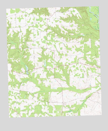
Methvins, GA USGS Topographic Map
Click on map above to begin viewing in our Map Viewer.

This topographic map contains these locations and features:
Feature Name Type Latitude Longitude GNIS ID View Map
Andersonville DivisionCivilN32.1224°W84.0868°1936080View Map
Bailey BranchStreamN32.0652°W84.1060°310720View Map
Bethel ChurchChurchN32.1054°W84.0899°311170View Map
Browns Mill (historical)LocaleN32.0488°W84.0980°343422View Map
Browns MillpondLakeN32.0542°W84.0988°311900View Map
Browns Millpond DamDamN32.0538°W84.0988°338037View Map
Chambliss School (historical)SchoolN32.1202°W84.0574°343427View Map
Corinth (historical)Populated PlaceN32.0507°W84.0218°343430View Map
Dominy BranchStreamN32.0324°W84.0032°313535View Map
Floyd Frazier LakeReservoirN32.1102°W84.0316°341324View Map
Floyd Frazier Lake DamDamN32.1102°W84.0316°341323View Map
Friendship CemeteryCemeteryN32.0132°W84.0513°314386View Map
Gamage School (historical)SchoolN32.0788°W84.0057°343448View Map
Hoke Smith Lake Dam EastDamN32.1035°W84.1216°341321View Map
Hoke Smith Lake Dam WestDamN32.1035°W84.1216°341319View Map
Hoke Smith Lake EastReservoirN32.1035°W84.1216°341322View Map
Hoke Smith Lake WestReservoirN32.1035°W84.1216°341320View Map
Hurricane BranchStreamN32.0696°W84.1060°315837View Map
Jimmy Green Lake DamDamN32.0885°W84.1199°341315View Map
Jimmy Green Lake Dam EastDamN32.0918°W84.1149°341317View Map
Jimmy Green Lake EastReservoirN32.0930°W84.1133°341318View Map
Jimmy Greene LakeReservoirN32.0885°W84.1199°341316View Map
LamarPopulated PlaceN32.0163°W84.0718°332174View Map
Little Lime CreekStreamN32.0424°W84.0927°317111View Map
MethvinsPopulated PlaceN32.1127°W84.0691°332376View Map
Mount Hope ChurchChurchN32.0268°W84.1096°318665View Map
Mount Pleasant Church (historical)ChurchN32.1199°W84.0591°343470View Map
New Corinth ChurchChurchN32.0527°W84.0224°319299View Map
Pat Crumpton LakeReservoirN32.0552°W84.0749°341314View Map
Pat Crumpton Lake DamDamN32.0552°W84.0749°341313View Map
Pleasant Grove CemeteryCemeteryN32.1210°W84.0568°320794View Map
Pleasant Grove Church (historical)ChurchN32.1204°W84.0582°343488View Map
Po Joe BranchStreamN32.0293°W84.0702°320957View Map
Union Grove ChurchChurchN32.1193°W84.0491°324545View Map
Welcome ChurchChurchN32.0779°W84.0707°324975View Map

Note: Coordinates in the location and feature list above are referenced to NAD83 datum.


Copyright (C) 2008-2024 Ryan Niemi / Sunset Dynamics ... All Rights Reserved