TopoQuest Logo
Do you find TopoQuest useful?
Help keep TopoQuest running and adding new maps/features by donating!
Bitcoin:  19c7KJd3qBynnjoSw5npx9KScwjBe4ifkT
Litecoin:  LXs6TkuXGGXo1vDsWCkWVdjQX94eUKd6ui
Home View Maps Find Maps Find Places Resources & Links


Mesquite Bay, Texas Topographic Map

USGS Map Title: Mesquite Bay, TX
USGS Map MRC: 28096B7
DRG (GeoTIFF) Download: o28096b7.tif


Neighboring USGS Topographic Map Quads:


  Tivoli SW, TX  
28096C8
 

  Tivoli SE, TX  
28096C7
 

  Mosquito Point, TX  
28096C6
 

  Saint Charles Bay, TX  
28096B8
 

  Mesquite Bay, TX  
28096B7
 

  Panther Point, TX  
28096B6
 

  Saint Charles Bay SW, TX  
28096A8
 

  Saint Charles Bay SE, TX  
28096A7


Map MRC Location:

N29°
W97°
N29°
W96°
H8 H7 H6 H5 H4 H3 H2 H1
G8 G7 G6 G5 G4 G3 G2 G1
F8 F7 F6 F5 F4 F3 F2 F1
E8 E7 E6 E5 E4 E3 E2 E1
D8 D7 D6 D5 D4 D3 D2 D1
C8 C7 C6 C5 C4 C3 C2 C1
B8 B7 B6 B5 B4 B3 B2 B1
A8 A7 A6 A5 A4 A3 A2 A1
N28°
W97°
N28°
W96°

Mesquite Bay, TX USGS 1:24K Topographic Map Preview:
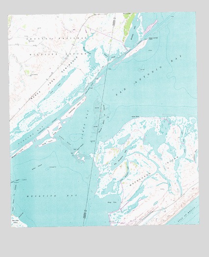
Mesquite Bay, TX USGS Topographic Map
Click on map above to begin viewing in our Map Viewer.

This topographic map contains these locations and features:
Feature Name Type Latitude Longitude GNIS ID View Map
Ayres BayBayN28.1878°W96.8261°1329887View Map
Ayres DugoutChannelN28.1689°W96.8317°1329888View Map
Ayres IslandIslandN28.1831°W96.8472°1329889View Map
Ayres PointCapeN28.1886°W96.7878°1384214View Map
Ayres ReefBarN28.1739°W96.8394°1329891View Map
Belden DugoutChannelN28.1606°W96.8575°1330354View Map
Big Brundrett LakeLakeN28.1762°W96.7889°1330569View Map
Bray CoveBayN28.1383°W96.8080°1331208View Map
Carlos WindmillLocaleN28.2147°W96.8605°1332164View Map
Cottonwood BayouLakeN28.1667°W96.7518°1333415View Map
False Live Oak PointCapeN28.2347°W96.7817°1335684View Map
Jack WindmillLocaleN28.2347°W96.8614°1338561View Map
Little Brundrett LakeLakeN28.1553°W96.7975°1340031View Map
Long LakeLakeN28.2080°W96.8429°1340486View Map
McMullen LakeLakeN28.2392°W96.7914°1381131View Map
Mesquite BayBayN28.1470°W96.8455°1341401View Map
Mustang LakeLakeN28.2392°W96.7919°1342320View Map
Mustang SloughLakeN28.2260°W96.8208°1342324View Map
Rattlesnake IslandIslandN28.1947°W96.8319°1344822View Map
Rattlesnake ReefBarN28.1322°W96.8697°1344829View Map
Redfish SloughGutN28.2245°W96.8072°1381132View Map
Roddy IslandIslandN28.1750°W96.8503°1345499View Map
Second Chain of IslandsIslandN28.1886°W96.8142°1346860View Map
Shell Reef BayouLakeN28.1784°W96.7603°1347017View Map
Sundown BayBayN28.1781°W96.8636°1348068View Map
Third Chain of IslandsIslandN28.1397°W96.8747°1348472View Map

Note: Coordinates in the location and feature list above are referenced to NAD83 datum.


Copyright (C) 2008-2024 Ryan Niemi / Sunset Dynamics ... All Rights Reserved