TopoQuest Logo
Do you find TopoQuest useful?
Help keep TopoQuest running and adding new maps/features by donating!
Bitcoin:  19c7KJd3qBynnjoSw5npx9KScwjBe4ifkT
Litecoin:  LXs6TkuXGGXo1vDsWCkWVdjQX94eUKd6ui
Home View Maps Find Maps Find Places Resources & Links


Mesita, New Mexico Topographic Map

USGS Map Title: Mesita, NM
USGS Map MRC: 35107A3
DRG (GeoTIFF) Download: o35107a3.tif


Neighboring USGS Topographic Map Quads:


  Seboyeta, NM  
35107B4
 

  Moquino, NM  
35107B3
 

  Arch Mesa, NM  
35107B2
 

  Laguna, NM  
35107A4
 

  Mesita, NM  
35107A3
 

  Mesa Gigante, NM  
35107A2
 

  South Butte, NM  
34107H4
 

  Dough Mountain, NM  
34107H3
 

  Correo, NM  
34107H2


Map MRC Location:

N36°
W108°
N36°
W107°
H8 H7 H6 H5 H4 H3 H2 H1
G8 G7 G6 G5 G4 G3 G2 G1
F8 F7 F6 F5 F4 F3 F2 F1
E8 E7 E6 E5 E4 E3 E2 E1
D8 D7 D6 D5 D4 D3 D2 D1
C8 C7 C6 C5 C4 C3 C2 C1
B8 B7 B6 B5 B4 B3 B2 B1
A8 A7 A6 A5 A4 A3 A2 A1
N35°
W108°
N35°
W107°

Mesita, NM USGS 1:24K Topographic Map Preview:
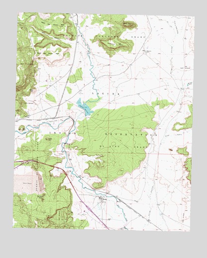
Mesita, NM USGS Topographic Map
Click on map above to begin viewing in our Map Viewer.

This topographic map contains these locations and features:
Feature Name Type Latitude Longitude GNIS ID View Map
114-Laguna InterchangeCrossingN35.0370°W107.3695°924441View Map
Alpine Miner Test AreaMineN35.1242°W107.3295°916897View Map
Arroyo de Piedra LumbreStreamN35.1139°W107.2639°900291View Map
Arroyo del ValleStreamN35.1142°W107.2637°900292View Map
Arroyo GiganteStreamN35.0539°W107.2698°897638View Map
Bell Rock ArroyoStreamN35.0803°W107.2584°886187View Map
BIA-RWP16A Water WellWellN35.0050°W107.2706°918477View Map
ECW-3 Water WellWellN35.1039°W107.2856°918860View Map
El RitoCivilN35.0412°W107.2964°888828View Map
F-9-2 MineMineN35.1242°W107.3556°916579View Map
Flint PeakSummitN35.0570°W107.3714°889095View Map
H-1 MineMineN35.1237°W107.3556°916580View Map
Heart PeakSummitN35.0798°W107.3631°899668View Map
Laguna PuebloCivilN35.0369°W107.2567°1934340View Map
M-6MineN35.0834°W107.2506°916588View Map
MarmonPopulated PlaceN35.0173°W107.3006°899752View Map
MesitaPopulated PlaceN35.0184°W107.3128°923627View Map
Mesita Census Designated PlaceCensusN35.0134°W107.3296°2408822View Map
Mesita SchoolSchoolN35.0062°W107.3084°891903View Map
Mesita Water WellWellN35.0184°W107.3106°919806View Map
Mesita WellMineN35.0384°W107.3192°916892View Map
Mesita WellWellN35.0250°W107.3256°929278View Map
North Oak Canyon MesaSummitN35.1173°W107.3448°892630View Map
Oak CanyonValleyN35.1075°W107.3339°892789View Map
Oak Creek Canyon DepositMineN35.1123°W107.3478°916912View Map
Paguate ReservoirReservoirN35.0704°W107.3267°893022View Map
QuirkLocaleN35.0478°W107.3489°932952View Map
Rio PaguateStreamN35.0617°W107.3331°923664View Map
RWP-28 Water WellWellN35.0645°W107.2973°918547View Map
Snowbird LakeLakeN35.1039°W107.2844°894975View Map
Snowbird MesaSummitN35.1081°W107.3037°899918View Map
South Oak Canyon MesaSummitN35.1006°W107.3548°895092View Map
Sunhouse PeaksSummitN35.0167°W107.3550°899933View Map
Wiener MesaSummitN35.1189°W107.2948°899992View Map
Wilcox Ranch DepositMineN35.0998°W107.3317°916430View Map
Yellow HillSummitN35.0514°W107.3520°900003View Map

Note: Coordinates in the location and feature list above are referenced to NAD83 datum.


Copyright (C) 2008-2024 Ryan Niemi / Sunset Dynamics ... All Rights Reserved