TopoQuest Logo
Do you find TopoQuest useful?
Help keep TopoQuest running and adding new maps/features by donating!
Bitcoin:  19c7KJd3qBynnjoSw5npx9KScwjBe4ifkT
Litecoin:  LXs6TkuXGGXo1vDsWCkWVdjQX94eUKd6ui
Home View Maps Find Maps Find Places Resources & Links


Mescalero, New Mexico Topographic Map

USGS Map Title: Mescalero, NM
USGS Map MRC: 33105B7
DRG (GeoTIFF) Download: o33105b7.tif


Neighboring USGS Topographic Map Quads:


  Golondrina Draw, NM  
33105C8
 

  Sierra Blanca Peak, NM  
33105C7
 

  Ruidoso, NM  
33105C6
 

  Cat Mountain, NM  
33105B8
 

  Mescalero, NM  
33105B7
 

  Apache Summit, NM  
33105B6
 

  Sabinata Flat, NM  
33105A8
 

  Domingo Peak, NM  
33105A7
 

  Firman Canyon, NM  
33105A6


Map MRC Location:

N34°
W106°
N34°
W105°
H8 H7 H6 H5 H4 H3 H2 H1
G8 G7 G6 G5 G4 G3 G2 G1
F8 F7 F6 F5 F4 F3 F2 F1
E8 E7 E6 E5 E4 E3 E2 E1
D8 D7 D6 D5 D4 D3 D2 D1
C8 C7 C6 C5 C4 C3 C2 C1
B8 B7 B6 B5 B4 B3 B2 B1
A8 A7 A6 A5 A4 A3 A2 A1
N33°
W106°
N33°
W105°

Mescalero, NM USGS 1:24K Topographic Map Preview:
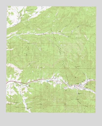
Mescalero, NM USGS Topographic Map
Click on map above to begin viewing in our Map Viewer.

This topographic map contains these locations and features:
Feature Name Type Latitude Longitude GNIS ID View Map
10144 Water WellWellN33.1306°W105.8489°926388View Map
Apache Indian Assembly of God ChurchChurchN33.1576°W105.7742°902150View Map
BentPopulated PlaceN33.1587°W105.8569°903754View Map
Bent Census Designated PlaceCensusN33.1473°W105.8590°2584054View Map
Bent Post OfficePost OfficeN33.1590°W105.8560°938106View Map
Bent Public SchoolSchoolN33.1618°W105.8458°903755View Map
Bent Volunteer Fire DepartmentBuildingN33.1630°W105.8437°2658038View Map
Blazers CemeteryCemeteryN33.1573°W105.7847°1987511View Map
Blazers MillPopulated PlaceN33.1565°W105.7875°903917View Map
Church SpringSpringN33.1543°W105.7642°1987512View Map
Danley TankReservoirN33.2173°W105.8264°905592View Map
Deep WellWellN33.2165°W105.8292°1987510View Map
Dry Can Water WellWellN33.2195°W105.8003°926608View Map
Dry Canyon WellWellN33.2206°W105.8005°905876View Map
Graveyard CanyonValleyN33.1559°W105.7794°906722View Map
Graveyard SpringSpringN33.1410°W105.7770°913385View Map
Ihs Hospital HeliportAirportN33.1626°W105.7644°936983View Map
Jose Carrillo CanyonValleyN33.2306°W105.8592°907379View Map
Mardem CanyonValleyN33.2187°W105.8033°908413View Map
Martin TankReservoirN33.2134°W105.7797°908430View Map
MescaleroPopulated PlaceN33.1576°W105.7742°923626View Map
Mescalero Apache Fire Rescue StationBuildingN33.1535°W105.7654°2657901View Map
Mescalero Baptist MissionChurchN33.1576°W105.7742°921239View Map
Mescalero Census Designated PlaceCensusN33.1448°W105.7897°2408821View Map
Mescalero Community Center LibraryBuildingN33.1559°W105.7742°929351View Map
Mescalero Indian CemeteryCemeteryN33.1476°W105.7761°908648View Map
Mescalero Indian HospitalHospitalN33.1588°W105.7724°2697007View Map
Mescalero Magnetite-HematiteMineN33.1770°W105.8050°916925View Map
Mescalero Post OfficePost OfficeN33.1576°W105.7742°938218View Map
Mescalero Reformed ChurchChurchN33.1576°W105.7742°902454View Map
Mescalero Weather StationLocaleN33.1576°W105.7742°931863View Map
Mountain Lion PeakSummitN33.1368°W105.8625°913384View Map
Nogal CanyonValleyN33.1590°W105.8664°909103View Map
Nogal SpringSpringN33.1295°W105.8461°1987513View Map
North Fork Tularosa CanyonValleyN33.1556°W105.7717°909157View Map
North SpringSpringN33.1945°W105.7639°914318View Map
Pinkey CanyonValleyN33.2401°W105.8511°909706View Map
Sacramento MountainsRangeN33.1265°W105.7519°920683View Map
Saint Joseph MissionChurchN33.1576°W105.7742°920128View Map
Saint Josephs MissionLocaleN33.1562°W105.7667°924762View Map
Saint Josephs Mission Historical MarkerParkN33.1562°W105.7742°932288View Map
Smith WellWellN33.2059°W105.8436°913382View Map
Soldier CanyonValleyN33.1645°W105.7628°913386View Map
Soldier TankReservoirN33.1801°W105.7783°911198View Map
South Fork Tularosa CanyonValleyN33.1556°W105.7717°911256View Map
South Rinconada CanyonValleyN33.2309°W105.8611°911269View Map
Telles SpringSpringN33.1539°W105.8620°913383View Map
The Church of Jesus Christ of Latter Day SaintsChurchN33.1576°W105.7742°901877View Map
Trail CanyonValleyN33.2062°W105.8428°913381View Map
Wallys Dome Historic SiteLocaleN33.1576°W105.7742°934432View Map
Walters CemeteryCemeteryN33.1587°W105.8569°931319View Map

Note: Coordinates in the location and feature list above are referenced to NAD83 datum.


Copyright (C) 2008-2024 Ryan Niemi / Sunset Dynamics ... All Rights Reserved