TopoQuest Logo
Do you find TopoQuest useful?
Help keep TopoQuest running and adding new maps/features by donating!
Bitcoin:  19c7KJd3qBynnjoSw5npx9KScwjBe4ifkT
Litecoin:  LXs6TkuXGGXo1vDsWCkWVdjQX94eUKd6ui
Home View Maps Find Maps Find Places Resources & Links


Mershon, Georgia Topographic Map

USGS Map Title: Mershon, GA
USGS Map MRC: 31082D3
DRG (GeoTIFF) Download: o31082d3.tif


Neighboring USGS Topographic Map Quads:


  Alma, GA  
31082E4
 

  Coffee, GA  
31082E3
 

  K'Ville, GA  
31082E2
 

  Crawley, GA  
31082D4
 

  Mershon, GA  
31082D3
 

  Patterson, GA  
31082D2
 

  Dixie Union, GA  
31082C4
 

  Blackshear West, GA  
31082C3
 

  Blackshear East, GA  
31082C2


Map MRC Location:

N32°
W83°
N32°
W82°
H8 H7 H6 H5 H4 H3 H2 H1
G8 G7 G6 G5 G4 G3 G2 G1
F8 F7 F6 F5 F4 F3 F2 F1
E8 E7 E6 E5 E4 E3 E2 E1
D8 D7 D6 D5 D4 D3 D2 D1
C8 C7 C6 C5 C4 C3 C2 C1
B8 B7 B6 B5 B4 B3 B2 B1
A8 A7 A6 A5 A4 A3 A2 A1
N31°
W83°
N31°
W82°

Mershon, GA USGS 1:24K Topographic Map Preview:
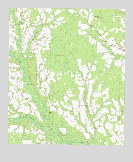
Mershon, GA USGS Topographic Map
Click on map above to begin viewing in our Map Viewer.

This topographic map contains these locations and features:
Feature Name Type Latitude Longitude GNIS ID View Map
Briar CreekStreamN31.4277°W82.3549°311767View Map
Bristol DivisionCivilN31.4370°W82.2503°1936132View Map
Byrum Siding (historical)LocaleN31.4916°W82.2876°349052View Map
Friendship CemeteryCemeteryN31.4871°W82.3423°1986508View Map
Friendship ChurchChurchN31.4863°W82.3424°314395View Map
Henderson CemeteryCemeteryN31.4041°W82.3271°315319View Map
Hurricane CreekStreamN31.3774°W82.3201°315849View Map
Little Hurricane CreekStreamN31.3774°W82.3201°317094View Map
MershonPopulated PlaceN31.4641°W82.2573°318049View Map
Mershon Baptist ChurchChurchN31.4634°W82.2587°349072View Map
Mershon CemeteryCemeteryN31.4663°W82.2623°318050View Map
Mill BranchStreamN31.4008°W82.3596°318176View Map
Northside Volunteer Fire DepartmentBuildingN31.4636°W82.2571°2604901View Map
Ramah CemeteryCemeteryN31.4113°W82.2882°349092View Map
Ramah ChurchChurchN31.4108°W82.2885°321298View Map
Ramah School (historical)SchoolN31.4272°W82.3010°349093View Map
Shady Grove Baptist ChurchChurchN31.4113°W82.3272°2502695View Map
Shady Grove ChurchChurchN31.4110°W82.3268°322742View Map
Sumner FordCrossingN31.4202°W82.3471°349099View Map
Sunset Volunteer Fire DepartmentBuildingN31.3868°W82.3507°2604905View Map
Sweat BridgeBridgeN31.3755°W82.2887°349100View Map
Sweat FordCrossingN31.3988°W82.3337°349101View Map
Ten Mile CemeteryCemeteryN31.4846°W82.3607°1986511View Map
Tenmile CreekStreamN31.4494°W82.3576°323993View Map
Tenmile Creek ChurchChurchN31.4855°W82.3612°323998View Map
WalkersvillePopulated PlaceN31.3938°W82.2760°333348View Map
Walkerville ChurchChurchN31.4030°W82.2715°324792View Map
Youmans CemeteryCemeteryN31.3764°W82.3291°325633View Map

Note: Coordinates in the location and feature list above are referenced to NAD83 datum.


Copyright (C) 2008-2024 Ryan Niemi / Sunset Dynamics ... All Rights Reserved