TopoQuest Logo
Do you find TopoQuest useful?
Help keep TopoQuest running and adding new maps/features by donating!
Bitcoin:  19c7KJd3qBynnjoSw5npx9KScwjBe4ifkT
Litecoin:  LXs6TkuXGGXo1vDsWCkWVdjQX94eUKd6ui
Home View Maps Find Maps Find Places Resources & Links


Mer Rouge, Louisiana Topographic Map

USGS Map Title: Mer Rouge, LA
USGS Map MRC: 32091G7
DRG (GeoTIFF) Download: o32091g7.tif


Neighboring USGS Topographic Map Quads:


  Beekman, LA  
32091H8
 

  Twin Oaks, LA  
32091H7
 

  Bonita, LA  
32091H6
 

  Bastrop, LA  
32091G8
 

  Mer Rouge, LA  
32091G7
 

  Bonita SW, LA  
32091G6
 

  Collinston West, LA  
32091F8
 

  Collinston East, LA  
32091F7
 

  Whitney Island North, LA  
32091F6


Map MRC Location:

N33°
W92°
N33°
W91°
H8 H7 H6 H5 H4 H3 H2 H1
G8 G7 G6 G5 G4 G3 G2 G1
F8 F7 F6 F5 F4 F3 F2 F1
E8 E7 E6 E5 E4 E3 E2 E1
D8 D7 D6 D5 D4 D3 D2 D1
C8 C7 C6 C5 C4 C3 C2 C1
B8 B7 B6 B5 B4 B3 B2 B1
A8 A7 A6 A5 A4 A3 A2 A1
N32°
W92°
N32°
W91°

Mer Rouge, LA USGS 1:24K Topographic Map Preview:
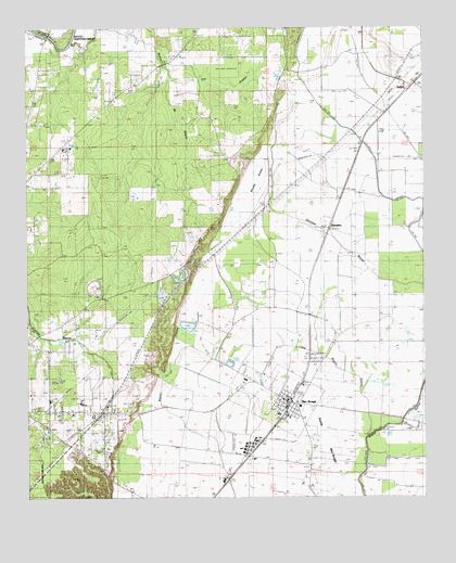
Mer Rouge, LA USGS Topographic Map
Click on map above to begin viewing in our Map Viewer.

This topographic map contains these locations and features:
Feature Name Type Latitude Longitude GNIS ID View Map
Arkla Flyers Inc AirportAirportN32.7658°W91.8001°1632847View Map
BastropPopulated PlaceN32.7562°W91.8723°1629913View Map
Bastrop Fire Department Station 4BuildingN32.8607°W91.8384°2672917View Map
Bayou de GlaizeStreamN32.8749°W91.8523°532404View Map
Cooper Lake (historical)LakeN32.8549°W91.7935°554083View Map
Cooper Lake CemeteryCemeteryN32.8547°W91.7964°534124View Map
Delta Middle SchoolSchoolN32.7549°W91.8136°556301View Map
Dunmore CemeteryCemeteryN32.8029°W91.8103°534657View Map
GalionPopulated PlaceN32.8596°W91.7532°535160View Map
Handy BrakeSwampN32.8350°W91.8024°535516View Map
Handy Brake National Wildlife RefugeParkN32.8308°W91.8050°2765334View Map
Hillview ChurchChurchN32.8149°W91.8235°535676View Map
Jelks BayouStreamN32.8732°W91.8421°536017View Map
Little Bayou GalionStreamN32.7668°W91.7682°536487View Map
Mer RougePopulated PlaceN32.7751°W91.7926°555297View Map
Mer Rouge CemeteryCemeteryN32.7753°W91.8423°537030View Map
Mer Rouge Elementary SchoolSchoolN32.7721°W91.7960°546706View Map
Mer Rouge Police DepartmentBuildingN32.7758°W91.7939°2755223View Map
Mer Rouge Post OfficePost OfficeN32.7766°W91.7957°1630658View Map
Mer Rouge Volunteer Fire DepartmentBuildingN32.7769°W91.7939°2672954View Map
Morehouse ParishCivilN32.8202°W91.8018°558097View Map
Moses Temple (historical)ChurchN32.8646°W91.7946°537245View Map
New Baptist Church (historical)ChurchN32.8437°W91.7985°537548View Map
Parish Governing Authority District 3CivilN32.7795°W91.8710°1929964View Map
Pine Grove Elementary SchoolSchoolN32.8431°W91.8631°2462920View Map
Prairie Mer RougeFlatN32.7643°W91.7812°538389View Map
Saint Matthew Church Number 2ChurchN32.7535°W91.8446°539000View Map
Saint Matthew SchoolSchoolN32.7607°W91.8040°539002View Map
StampleyPopulated PlaceN32.8218°W91.7798°539618View Map
The GladesStreamN32.8624°W91.8298°539849View Map
Village of Mer RougeCivilN32.7767°W91.7949°2407500View Map
Ward SixCivilN32.7726°W91.7787°545133View Map
Wards Ferry (historical)CrossingN32.8732°W91.8682°546737View Map
Washington ChapelChurchN32.8621°W91.8707°540243View Map

Note: Coordinates in the location and feature list above are referenced to NAD83 datum.


Copyright (C) 2008-2024 Ryan Niemi / Sunset Dynamics ... All Rights Reserved