TopoQuest Logo
Do you find TopoQuest useful?
Help keep TopoQuest running and adding new maps/features by donating!
Bitcoin:  19c7KJd3qBynnjoSw5npx9KScwjBe4ifkT
Litecoin:  LXs6TkuXGGXo1vDsWCkWVdjQX94eUKd6ui
Home View Maps Find Maps Find Places Resources & Links


Medon, Tennessee Topographic Map

USGS Map Title: Medon, TN
USGS Map MRC: 35088D7
DRG (GeoTIFF) Download: o35088d7.tif


Neighboring USGS Topographic Map Quads:


  Westover, TN  
35088E8
 

  Jackson South, TN  
35088E7
 

  Beech Bluff, TN  
35088E6
 

  Teague, TN  
35088D8
 

  Medon, TN  
35088D7
 

  Henderson, TN  
35088D6
 

  Bolivar East, TN  
35088C8
 

  Silerton, TN  
35088C7
 

  Masseyville, TN  
35088C6


Map MRC Location:

N36°
W89°
N36°
W88°
H8 H7 H6 H5 H4 H3 H2 H1
G8 G7 G6 G5 G4 G3 G2 G1
F8 F7 F6 F5 F4 F3 F2 F1
E8 E7 E6 E5 E4 E3 E2 E1
D8 D7 D6 D5 D4 D3 D2 D1
C8 C7 C6 C5 C4 C3 C2 C1
B8 B7 B6 B5 B4 B3 B2 B1
A8 A7 A6 A5 A4 A3 A2 A1
N35°
W89°
N35°
W88°

Medon, TN USGS 1:24K Topographic Map Preview:
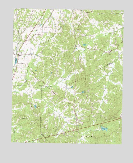
Medon, TN USGS Topographic Map
Click on map above to begin viewing in our Map Viewer.

This topographic map contains these locations and features:
Feature Name Type Latitude Longitude GNIS ID View Map
Allen CreekStreamN35.4823°W88.7514°1275595View Map
Bear CreekStreamN35.4426°W88.7628°1276575View Map
Bear Creek CemeteryCemeteryN35.4670°W88.7562°1954371View Map
Bear Creek ChurchChurchN35.4670°W88.7570°1276605View Map
Ben Henry LakeReservoirN35.4090°W88.8485°1276989View Map
Ben Henry Lake DamDamN35.4104°W88.8492°1307117View Map
Bethel Baptist ChurchChurchN35.3867°W88.8014°1305128View Map
Bethel CemeteryCemeteryN35.3870°W88.8009°1644617View Map
Big Springs CemeteryCemeteryN35.3959°W88.8434°1319740View Map
Big Springs ChurchChurchN35.3965°W88.8439°1277427View Map
Burkhad Chapel (historical)ChurchN35.3906°W88.7520°1316652View Map
Butler CemeteryCemeteryN35.4976°W88.7917°1279174View Map
Chester County Fire Department / Deanburg Volunteer Fire Department Station 540BuildingN35.3934°W88.8021°2654267View Map
City of MedonCivilN35.4561°W88.8645°2405063View Map
Clover Creek ChurchChurchN35.4420°W88.8731°1280772View Map
Clover Creek ChurchChurchN35.4526°W88.8695°1280773View Map
Commissioner District 6CivilN35.4948°W88.8091°2464557View Map
Couples Store (historical)LocaleN35.4417°W88.7689°1316662View Map
DeanburgPopulated PlaceN35.4123°W88.8059°1306306View Map
Deanburg Hills DamDamN35.4384°W88.7784°1301842View Map
Deanburg Hills LakeReservoirN35.4384°W88.7784°1301841View Map
Deanburg School (historical)SchoolN35.4129°W88.8092°1316664View Map
Deer CreekStreamN35.4823°W88.7537°2740977View Map
Fern Loop Nature TrailTrailN35.3898°W88.7778°1316668View Map
Forked Pine Nature TrailTrailN35.3931°W88.7687°1316671View Map
King DamDamN35.3934°W88.8367°1301799View Map
King LakeReservoirN35.3943°W88.8362°1307114View Map
Lacy CreekStreamN35.4229°W88.8726°1290447View Map
Lake PlacidReservoirN35.3892°W88.7698°1307112View Map
Lake Placid CampLocaleN35.3876°W88.7689°1316684View Map
Lake Placid DamDamN35.3887°W88.7726°1307113View Map
Lakeshore Nature TrailTrailN35.3865°W88.7662°1316685View Map
Lowery CemeteryCemeteryN35.4284°W88.8376°1292230View Map
Madison County Fire Department Station 9BuildingN35.4594°W88.8665°2654208View Map
McDaniel CemeteryCemeteryN35.4573°W88.8545°1293239View Map
MedonPopulated PlaceN35.4573°W88.8687°1293534View Map
Medon Post OfficePost OfficeN35.4565°W88.8689°1651644View Map
Nelson BranchStreamN35.4787°W88.7614°1295366View Map
New ChurchChurchN35.4698°W88.8673°1295464View Map
Owens CemeteryCemeteryN35.3795°W88.7659°1296572View Map
Owens Mills (historical)LocaleN35.3892°W88.7731°1316694View Map
ParkburgPopulated PlaceN35.4656°W88.8045°1315676View Map
Parkburg ChurchChurchN35.4817°W88.8026°1296789View Map
Parker CemeteryCemeteryN35.4653°W88.8034°1296805View Map
Parlow CemeteryCemeteryN35.4267°W88.8501°1296866View Map
Pleasant Springs CemeteryCemeteryN35.4181°W88.7898°1644640View Map
Pleasant Springs ChurchChurchN35.4187°W88.7895°1297928View Map
Rosenwald SchoolSchoolN35.4998°W88.8295°1300105View Map
Scott LakeReservoirN35.4231°W88.7947°1300958View Map
Shiloh School (historical)SchoolN35.3759°W88.8103°1316706View Map
Wilderwood DamDamN35.4551°W88.7667°1301856View Map
Wilderwood LakeReservoirN35.4551°W88.7667°1301855View Map

Note: Coordinates in the location and feature list above are referenced to NAD83 datum.


Copyright (C) 2008-2024 Ryan Niemi / Sunset Dynamics ... All Rights Reserved