TopoQuest Logo
Do you find TopoQuest useful?
Help keep TopoQuest running and adding new maps/features by donating!
Bitcoin:  19c7KJd3qBynnjoSw5npx9KScwjBe4ifkT
Litecoin:  LXs6TkuXGGXo1vDsWCkWVdjQX94eUKd6ui
Home View Maps Find Maps Find Places Resources & Links


Medina Lake, Texas Topographic Map

USGS Map Title: Medina Lake, TX
USGS Map MRC: 29098E8
DRG (GeoTIFF) Download: o29098e8.tif


Neighboring USGS Topographic Map Quads:


  Bandera, TX  
29099F1
 

  Pipe Creek, TX  
29098F8
 

  Jack Mountain, TX  
29098F7
 

  Timber Creek, TX  
29099E1
 

  Medina Lake, TX  
29098E8
 

  San Geronimo, TX  
29098E7
 

  Quihi, TX  
29099D1
 

  Riomedina, TX  
29098D8
 

  La Coste NE, TX  
29098D7


Map MRC Location:

N30°
W99°
N30°
W98°
H8 H7 H6 H5 H4 H3 H2 H1
G8 G7 G6 G5 G4 G3 G2 G1
F8 F7 F6 F5 F4 F3 F2 F1
E8 E7 E6 E5 E4 E3 E2 E1
D8 D7 D6 D5 D4 D3 D2 D1
C8 C7 C6 C5 C4 C3 C2 C1
B8 B7 B6 B5 B4 B3 B2 B1
A8 A7 A6 A5 A4 A3 A2 A1
N29°
W99°
N29°
W98°

Medina Lake, TX USGS 1:24K Topographic Map Preview:
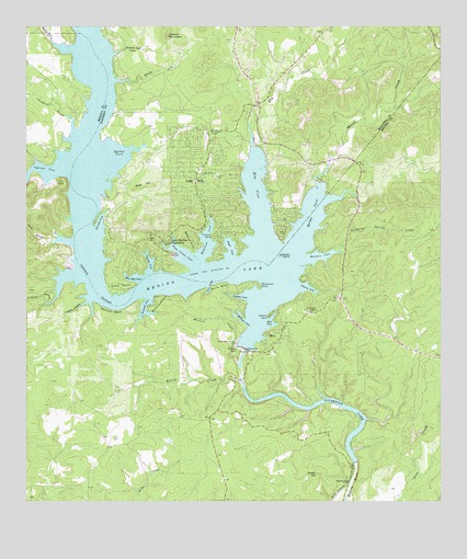
Medina Lake, TX USGS Topographic Map
Click on map above to begin viewing in our Map Viewer.

This topographic map contains these locations and features:
Feature Name Type Latitude Longitude GNIS ID View Map
Angel CoveBayN29.5669°W98.9381°1329551View Map
Antone HollowValleyN29.5527°W98.9942°1329618View Map
Baltzells Las Brisas HeliportAirportN29.5883°W98.9464°1386200View Map
Bandara County ParkParkN29.5652°W98.9553°1329877View Map
Bandera County Constable's Office Precinct 2BuildingN29.6043°W98.9314°2750707View Map
Bandera County ParkParkN29.5650°W98.9564°2028809View Map
Bandera County Sheriff's OfficeBuildingN29.6088°W98.9300°2750249View Map
Beacon PointCapeN29.5663°W98.9489°1330186View Map
Blue Bill CoveBayN29.5597°W98.9678°1330892View Map
Brushy CreekStreamN29.6111°W98.9731°1331419View Map
Campground SpringSpringN29.5880°W98.9989°1998456View Map
Carters PointCapeN29.5488°W98.9267°1332229View Map
Cedar HillSummitN29.5075°W98.9125°1332441View Map
Cherry CoveBayN29.5569°W98.9153°1332708View Map
Church CoveBayN29.5633°W98.9625°1332824View Map
Cousins PointCapeN29.5702°W98.9436°1333529View Map
Cypress CoveBayN29.5869°W98.9950°1333849View Map
Devils BluffCliffN29.5575°W98.9423°1334292View Map
Devils KitchenBayN29.5561°W98.9448°1334303View Map
Diversion Dam SpringsSpringN29.5086°W98.9086°1998459View Map
Diversion LakeReservoirN29.5247°W98.9151°1334393View Map
Dripping Spring CreekStreamN29.5675°W98.9048°1334616View Map
Echo PointCapeN29.5575°W98.9675°1335073View Map
Elm CoveBayN29.5838°W98.9303°1335350View Map
Elm CreekStreamN29.5936°W98.9314°1335366View Map
Fauries CoveBayN29.5738°W98.9775°1335729View Map
Goat HillSummitN29.5833°W98.9620°1336608View Map
Habys CoveBayN29.5763°W98.9131°1337174View Map
HamiltonBayN29.5675°W98.9448°1337273View Map
Henderson HollowValleyN29.6016°W98.9881°1337600View Map
Koenig CreekStreamN29.5316°W98.9353°1339210View Map
KRRT-TV (Kerrville)TowerN29.6105°W98.8934°1388150View Map
Lake HillsPopulated PlaceN29.5844°W98.9489°1339504View Map
Lake Medina HighlandsPopulated PlaceN29.5680°W98.9573°1339507View Map
LakehillsPopulated PlaceN29.6047°W98.9431°1867553View Map
Lakehills Census Designated PlaceCensusN29.6237°W98.9448°2408557View Map
Liebold MountainSummitN29.6227°W98.9570°1339902View Map
Masterson HeliportAirportN29.5566°W98.9298°1387186View Map
Masterson PointCapeN29.5563°W98.9292°1341065View Map
Medina DamDamN29.5403°W98.9344°1341323View Map
Medina Diversion Lake DamDamN29.5105°W98.9010°1857771View Map
Medina LakeReservoirN29.5602°W98.9505°1341324View Map
Medina Lake Volunteer Fire Department Station 1BuildingN29.5962°W98.9456°2551311View Map
Mescal CreekStreamN29.5841°W98.9123°1341397View Map
Mexican CreekStreamN29.5369°W98.9361°1341446View Map
MicoPopulated PlaceN29.5441°W98.9231°1341465View Map
Mico Volunteer Fire Department Base StationBuildingN29.5455°W98.9227°2551207View Map
Milligan CoveBayN29.5480°W98.9339°1341682View Map
Mormon BluffCliffN29.5508°W98.9748°1341922View Map
Plum Creek CoveBayN29.5647°W98.9528°1344273View Map
Point ComfortCapeN29.5538°W98.9611°1344297View Map
Polecat HollowValleyN29.5529°W98.9816°1344315View Map
Red CoveBayN29.5472°W98.9256°1344903View Map
Reuters CoveBayN29.5641°W98.9117°1345122View Map
Rocky CreekStreamN29.6224°W98.9928°1345456View Map
Saint Francis ChapelChurchN29.5505°W98.9123°1345890View Map
Saint Victors ChapelChurchN29.5983°W98.9436°1346132View Map
Sawmill CoveBayN29.5519°W98.9645°1346738View Map
Seekatz CoveBayN29.5544°W98.9348°1346873View Map
Spanish Oak CreekStreamN29.6180°W98.9734°1347625View Map
Spettel CoveBayN29.5911°W98.9723°1347650View Map
Turks HeadSummitN29.5844°W98.9886°1348898View Map
Walton IslandIslandN29.5650°W98.9231°1349463View Map
Water CanyonValleyN29.5685°W98.9937°1349534View Map

Note: Coordinates in the location and feature list above are referenced to NAD83 datum.


Copyright (C) 2008-2024 Ryan Niemi / Sunset Dynamics ... All Rights Reserved