TopoQuest Logo
Do you find TopoQuest useful?
Help keep TopoQuest running and adding new maps/features by donating!
Bitcoin:  19c7KJd3qBynnjoSw5npx9KScwjBe4ifkT
Litecoin:  LXs6TkuXGGXo1vDsWCkWVdjQX94eUKd6ui
Home View Maps Find Maps Find Places Resources & Links


Mebane, North Carolina Topographic Map

USGS Map Title: Mebane, NC
USGS Map MRC: 36079A3
DRG (GeoTIFF) Download: o36079a3.tif


Neighboring USGS Topographic Map Quads:


  Lake Burlington, NC  
36079B4
 

  Burlington NE, NC  
36079B3
 

  Cedar Grove, NC  
36079B2
 

  Burlington, NC  
36079A4
 

  Mebane, NC  
36079A3
 

  Efland, NC  
36079A2
 

  Snow Camp, NC  
35079H4
 

  Saxapahaw, NC  
35079H3
 

  White Cross, NC  
35079H2


Map MRC Location:

N37°
W80°
N37°
W79°
H8 H7 H6 H5 H4 H3 H2 H1
G8 G7 G6 G5 G4 G3 G2 G1
F8 F7 F6 F5 F4 F3 F2 F1
E8 E7 E6 E5 E4 E3 E2 E1
D8 D7 D6 D5 D4 D3 D2 D1
C8 C7 C6 C5 C4 C3 C2 C1
B8 B7 B6 B5 B4 B3 B2 B1
A8 A7 A6 A5 A4 A3 A2 A1
N36°
W80°
N36°
W79°

Mebane, NC USGS 1:24K Topographic Map Preview:
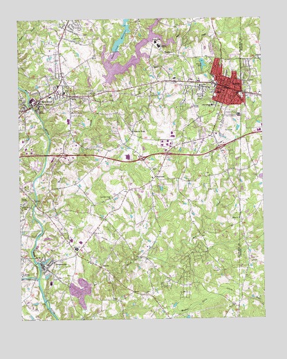
Mebane, NC USGS Topographic Map
Click on map above to begin viewing in our Map Viewer.

This topographic map contains these locations and features:
Feature Name Type Latitude Longitude GNIS ID View Map
Alamance Community CollegeSchoolN36.0665°W79.3575°2014032View Map
Arrowhead Golf ClubLocaleN36.0799°W79.2659°1003497View Map
Back CreekStreamN36.0457°W79.3678°1018893View Map
Belview ChurchChurchN36.1087°W79.3375°980973View Map
Big Alamance CreekStreamN36.0174°W79.3659°981297View Map
Brook HollowPopulated PlaceN36.0779°W79.2856°1003496View Map
Buena Vista EstatesPopulated PlaceN36.0812°W79.2786°1003498View Map
City of MebaneCivilN36.0878°W79.2752°2405061View Map
Cooper EstatesPopulated PlaceN36.0443°W79.3695°1003504View Map
Eastern High SchoolSchoolN36.1135°W79.3028°984553View Map
Eastern Middle SchoolSchoolN36.1151°W79.3047°984554View Map
Eastside ChurchChurchN36.0982°W79.2567°984569View Map
Edgewood ChurchChurchN36.1054°W79.3050°984638View Map
Florence TownPopulated PlaceN36.0776°W79.3164°1020294View Map
Forest LakeLakeN36.1063°W79.2799°985279View Map
Forest LakeReservoirN36.1235°W79.2797°1000123View Map
Forest Lake DamDamN36.1235°W79.2797°1000122View Map
Graham City Lake Number Two (historical)ReservoirN36.1085°W79.3281°1024773View Map
Graham City Lake Number Two Dam (historical)DamN36.1085°W79.3281°1024772View Map
Graham Lake (historical)LakeN36.0976°W79.3345°1024759View Map
Graham Memorial ParkCemeteryN36.0454°W79.3720°985913View Map
Granite VillagePopulated PlaceN36.0910°W79.3742°1003509View Map
Green LevelPopulated PlaceN36.1210°W79.3442°1027611View Map
Green Level ChurchChurchN36.1160°W79.3456°986066View Map
Haw RiverPopulated PlaceN36.0915°W79.3642°1024761View Map
Haw River Elementary SchoolSchoolN36.0929°W79.3584°1003493View Map
Haw River Fire DepartmentBuildingN36.0917°W79.3634°2639718View Map
Haw River ParkParkN36.0993°W79.3478°1003510View Map
Haw River Police DepartmentBuildingN36.0913°W79.3639°2769639View Map
Haw River Post OfficePost OfficeN36.0953°W79.3554°2774348View Map
HawfieldsPopulated PlaceN36.0593°W79.3050°1020642View Map
Hawfields ChurchChurchN36.0593°W79.3059°1023497View Map
Hawfields United ChurchChurchN36.0501°W79.3281°986523View Map
Hebron ChurchChurchN36.0418°W79.2622°986583View Map
Hurdle FieldAirportN36.0727°W79.2795°998022View Map
Kimrey AirportAirportN36.0558°W79.3249°2679225View Map
Lakeview AcresPopulated PlaceN36.1099°W79.2503°1002522View Map
Latham LakeLakeN36.0893°W79.3039°988161View Map
MebanePopulated PlaceN36.0960°W79.2670°1021404View Map
Mebane Fire Department North Side StationBuildingN36.1018°W79.2709°2639813View Map
Mebane Fire Department South Side StationBuildingN36.0958°W79.2684°2638431View Map
Mebane Police DepartmentBuildingN36.0968°W79.2688°2769691View Map
Mebane Post OfficePost OfficeN36.0784°W79.2910°2774314View Map
MelvillePopulated PlaceN36.0218°W79.3334°989716View Map
Mill CreekStreamN36.1176°W79.3061°989952View Map
Oakwood CemeteryCemeteryN36.0933°W79.2603°991493View Map
Philips ChapelChurchN36.0082°W79.3250°992139View Map
Piedmont Crescent Golf Course LakReservoirN36.0341°W79.3609°999940View Map
Quaker CreekStreamN36.1032°W79.3270°992929View Map
Quaker Creek ReservoirReservoirN36.1050°W79.3190°992930View Map
Quarry Hills Country Club and Golf CourseLocaleN36.0329°W79.3550°1003505View Map
Rice Airfarm (historical)AirportN36.0265°W79.2500°998017View Map
Riverside ChurchChurchN36.0499°W79.3675°993395View Map
Saint Lukes ChurchChurchN36.0990°W79.2881°994001View Map
South Mebane SchoolSchoolN36.0887°W79.2753°995176View Map
Stagecoach TrailPopulated PlaceN36.1104°W79.2628°1003499View Map
SwepsonvillePopulated PlaceN36.0212°W79.3614°1022870View Map
Swepsonville Volunteer Fire Department Station 1BuildingN36.0226°W79.3617°2639785View Map
Technical College of AlamanceSchoolN36.0676°W79.3561°1003503View Map
Town of Green LevelCivilN36.1220°W79.3466°2406610View Map
Town of Haw RiverCivilN36.0931°W79.3616°2405805View Map
Town of SwepsonvilleCivilN36.0285°W79.3548°2406703View Map
Township 10-MelvilleCivilN36.0777°W79.3003°1026352View Map
Township 13-Haw RiverCivilN36.1051°W79.3472°1026355View Map
Trinity ChurchChurchN36.0107°W79.3106°1024796View Map
West End SchoolSchoolN36.0968°W79.2817°997010View Map
WHNI-AM (Mebane)TowerN36.0579°W79.2764°1018533View Map
Wilson SchoolSchoolN36.0293°W79.3456°997461View Map
WoodlawnPopulated PlaceN36.1101°W79.2953°1023315View Map
Woodlawn Census Designated PlaceCensusN36.1157°W79.2894°2403039View Map
Yoder SchoolSchoolN36.1004°W79.2750°997721View Map

Note: Coordinates in the location and feature list above are referenced to NAD83 datum.


Copyright (C) 2008-2024 Ryan Niemi / Sunset Dynamics ... All Rights Reserved