TopoQuest Logo
Do you find TopoQuest useful?
Help keep TopoQuest running and adding new maps/features by donating!
Bitcoin:  19c7KJd3qBynnjoSw5npx9KScwjBe4ifkT
Litecoin:  LXs6TkuXGGXo1vDsWCkWVdjQX94eUKd6ui
Home View Maps Find Maps Find Places Resources & Links


Bear Mountain, Montana Topographic Map

USGS Map Title: Bear Mountain, MT
USGS Map MRC: 47108H4
DRG (GeoTIFF) Download: o47108h4.tif


Neighboring USGS Topographic Map Quads:


  Lodge Pole, MT  
48108A5
 

  Ball Coulee, MT  
48108A4
 

  Ester Lake, MT  
48108A3
 

  Zortman, MT  
47108H5
 

  Bear Mountain, MT  
47108H4
 

  Coburn Butte, MT  
47108H3
 

  Hays SE, MT  
47108G5
 

  Robinson School, MT  
47108G4
 

  Bison Bone Reservoir, MT  
47108G3


Map MRC Location:

N48°
W109°
N48°
W108°
H8 H7 H6 H5 H4 H3 H2 H1
G8 G7 G6 G5 G4 G3 G2 G1
F8 F7 F6 F5 F4 F3 F2 F1
E8 E7 E6 E5 E4 E3 E2 E1
D8 D7 D6 D5 D4 D3 D2 D1
C8 C7 C6 C5 C4 C3 C2 C1
B8 B7 B6 B5 B4 B3 B2 B1
A8 A7 A6 A5 A4 A3 A2 A1
N47°
W109°
N47°
W108°

Bear Mountain, MT USGS 1:24K Topographic Map Preview:
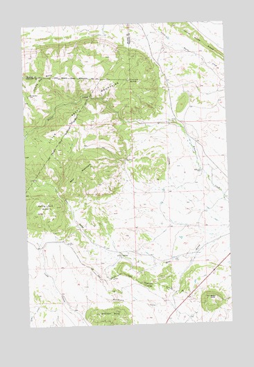
Bear Mountain, MT USGS Topographic Map
Click on map above to begin viewing in our Map Viewer.

This topographic map contains these locations and features:
Feature Name Type Latitude Longitude GNIS ID View Map
25N25E23ABC_01 WellWellN47.9111°W108.4643°825198View Map
25N25E24DCBA01 WellWellN47.9039°W108.4432°825189View Map
25N26E05BAC_01 WellWellN47.9564°W108.4051°825281View Map
25N26E05BADB01 WellWellN47.9564°W108.4038°825280View Map
25N26E05DDBA01 WellWellN47.9472°W108.3946°825256View Map
25N26E08ADAA01 WellWellN47.9408°W108.3924°825244View Map
25N26E08ADD_02 WellWellN47.9381°W108.3921°825234View Map
25N26E08ADDA01 WellWellN47.9381°W108.3924°825235View Map
25N26E09BCC_01 WellWellN47.9375°W108.3901°825231View Map
25N26E09CDB_01 WellWellN47.9322°W108.3851°825225View Map
25N26E16BDA_01 WellWellN47.9253°W108.3815°825214View Map
26N25E24BCDB01 SpringSpringN47.9958°W108.4515°825413View Map
26N25E24BDBC01 SpringSpringN47.9964°W108.4499°825415View Map
26N25E24BDDC01 SpringSpringN47.9956°W108.4474°825410View Map
26N26E32ACAA01 SpringSpringN47.9692°W108.3968°825306View Map
26N26E32ADBB01 SpringSpringN47.9692°W108.3965°825305View Map
Baker Creek School (historical)SchoolN47.9383°W108.3918°768461View Map
Bear MountainSummitN47.9347°W108.4713°768601View Map
Belmont Post Office (historical)Post OfficeN47.9883°W108.3896°1722096View Map
Coming Day ButteSummitN47.9786°W108.4907°770050View Map
Ricker ButteSummitN47.8858°W108.3896°775755View Map
Sharette ButteSummitN47.8806°W108.4465°776405View Map
Spring Park ButteSummitN47.9242°W108.4863°802201View Map
Travois ButteSummitN47.9764°W108.4374°777745View Map

Note: Coordinates in the location and feature list above are referenced to NAD83 datum.


Copyright (C) 2008-2024 Ryan Niemi / Sunset Dynamics ... All Rights Reserved