TopoQuest Logo
Do you find TopoQuest useful?
Help keep TopoQuest running and adding new maps/features by donating!
Bitcoin:  19c7KJd3qBynnjoSw5npx9KScwjBe4ifkT
Litecoin:  LXs6TkuXGGXo1vDsWCkWVdjQX94eUKd6ui
Home View Maps Find Maps Find Places Resources & Links


McCalla, Alabama Topographic Map

USGS Map Title: McCalla, AL
USGS Map MRC: 33087C1
DRG (GeoTIFF) Download: o33087c1.tif


Neighboring USGS Topographic Map Quads:


  Oak Grove, AL  
33087D2
 

  Concord, AL  
33087D1
 

  Bessemer, AL  
33086D8
 

  Abernant, AL  
33087C2
 

  McCalla, AL  
33087C1
 

  Greenwood, AL  
33086C8
 

  Woodstock, AL  
33087B2
 

  Halfmile Shoals, AL  
33087B1
 

  Pea Ridge, AL  
33086B8


Map MRC Location:

N34°
W88°
N34°
W87°
H8 H7 H6 H5 H4 H3 H2 H1
G8 G7 G6 G5 G4 G3 G2 G1
F8 F7 F6 F5 F4 F3 F2 F1
E8 E7 E6 E5 E4 E3 E2 E1
D8 D7 D6 D5 D4 D3 D2 D1
C8 C7 C6 C5 C4 C3 C2 C1
B8 B7 B6 B5 B4 B3 B2 B1
A8 A7 A6 A5 A4 A3 A2 A1
N33°
W88°
N33°
W87°

McCalla, AL USGS 1:24K Topographic Map Preview:
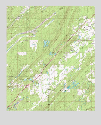
McCalla, AL USGS Topographic Map
Click on map above to begin viewing in our Map Viewer.

This topographic map contains these locations and features:
Feature Name Type Latitude Longitude GNIS ID View Map
Antioch Baptist ChurchChurchN33.2818°W87.1047°113112View Map
Baylor (historical)LocaleN33.2882°W87.0439°143989View Map
Baylor LakeReservoirN33.2918°W87.0337°131407View Map
Baylor Lake DamDamN33.2918°W87.0350°131406View Map
Bellview ChurchChurchN33.2740°W87.0600°113894View Map
Big Griffin LakeReservoirN33.3334°W87.0700°131452View Map
Black CreekStreamN33.2501°W87.0172°114414View Map
Black DiamondPopulated PlaceN33.3448°W87.0867°151689View Map
Black Diamond Lake DamDamN33.3301°W87.0833°131446View Map
Blue CreekPopulated PlaceN33.3709°W87.0761°156079View Map
Blue Creek Lake DamDamN33.3334°W87.0700°131451View Map
Blue Creek MineMineN33.3598°W87.0944°146200View Map
BucksvillePopulated PlaceN33.2784°W87.0856°157903View Map
Bucksville CemeteryCemeteryN33.2773°W87.0855°147916View Map
Bucksville School (historical)SchoolN33.2779°W87.0869°147917View Map
Burnt Bridge BranchStreamN33.3384°W87.0975°115262View Map
Camp NawakaLocaleN33.3054°W87.0708°115472View Map
ChinnPopulated PlaceN33.3721°W87.0481°156177View Map
Cloester ValleyPopulated PlaceN33.2862°W87.1189°147993View Map
Coleman LakesReservoirN33.2799°W87.0342°116414View Map
Coleman Lakes Number 1 DamDamN33.2834°W87.0283°131388View Map
Confederate Hill EstatesPopulated PlaceN33.2551°W87.0794°148916View Map
Cooley CreekStreamN33.2640°W87.0628°116549View Map
Cox Spring BranchStreamN33.3471°W87.0211°116793View Map
Davis (historical)LocaleN33.2929°W87.0639°151319View Map
Ellis LakeReservoirN33.3279°W87.0675°131443View Map
Ellis Lake DamDamN33.3284°W87.0683°131442View Map
Faith SchoolSchoolN33.2857°W87.0308°118166View Map
First Baptist Church of BucksvilleChurchN33.2779°W87.0861°148919View Map
Flint HillPopulated PlaceN33.3551°W87.0064°118428View Map
Frawley (historical)LocaleN33.3084°W87.0344°144213View Map
Getmore Number 2 MineMineN33.3598°W87.0694°163288View Map
Gilbert Thomas LakeReservoirN33.2866°W87.0987°118941View Map
Gilbert Tommie Lake DamDamN33.2868°W87.0900°131395View Map
Gilbert Tommie Number 2 DamDamN33.2868°W87.0967°131396View Map
Gitmore MinesMineN33.3687°W87.0753°154241View Map
Goethite (historical)LocaleN33.2707°W87.0978°148183View Map
Green Isle Country ClubLocaleN33.3504°W87.0055°164335View Map
Griffin LakesLakeN33.3180°W87.0622°157975View Map
Hicks SpringSpringN33.2983°W87.0538°120043View Map
Indian Gap LakeReservoirN33.2825°W87.0239°151853View Map
Indian Gap Lake DamDamN33.2834°W87.0217°131386View Map
Interchange 100CrossingN33.2796°W87.0958°155720View Map
Interchange 104CrossingN33.3229°W87.0492°155721View Map
Interchange 106CrossingN33.3432°W87.0267°155722View Map
JohnsPopulated PlaceN33.3618°W87.1097°120921View Map
Johns Elementary School (historical)SchoolN33.3682°W87.1033°144315View Map
Johnson LakeReservoirN33.2823°W87.1198°148472View Map
Jones ValleyValleyN33.2729°W87.0714°151918View Map
KimbrellPopulated PlaceN33.2762°W87.0672°151955View Map
Kimbrell Lake DamDamN33.2934°W87.0667°131409View Map
Lake Griffin DamDamN33.3151°W87.0767°131428View Map
Lake View Police DepartmentBuildingN33.2704°W87.0795°2751818View Map
Lakeview Fire Department Station 2BuildingN33.2792°W87.0848°2682795View Map
LawsontownPopulated PlaceN33.3340°W87.0986°156589View Map
Lick BranchStreamN33.3440°W87.0928°121579View Map
Lincoln CemeteryCemeteryN33.3498°W87.0222°121653View Map
Little Griffin LakeReservoirN33.3151°W87.0767°131429View Map
LowetownPopulated PlaceN33.3087°W87.0753°122089View Map
Marvin Chapel CemeteryCemeteryN33.2640°W87.0303°138749View Map
Mc Calla Post OfficePost OfficeN33.3265°W87.0280°2788920View Map
McAdory Elementary SchoolSchoolN33.3298°W87.0019°144366View Map
McAdory Fire and Rescue Station 2BuildingN33.3087°W87.0237°2682890View Map
McAdory High SchoolSchoolN33.3309°W87.0008°152257View Map
McAshan MountainSummitN33.3184°W87.0478°122446View Map
McCallaPopulated PlaceN33.3487°W87.0142°122460View Map
McCalla Area Fire District Station 1BuildingN33.3220°W87.0564°2682860View Map
McCalla Area Fire District Station 2BuildingN33.3275°W87.0280°2683372View Map
McCalla Baptist ChurchChurchN33.3493°W87.0147°148781View Map
McCalla ChapelChurchN33.3465°W87.0225°122461View Map
McCalla Lake DamDamN33.3384°W87.0217°131459View Map
McCalla Station (historical)LocaleN33.3348°W87.0078°144402View Map
McKelveys LakesReservoirN33.3379°W87.0215°131458View Map
McNathsLocaleN33.2843°W87.0764°144372View Map
Mill CreekStreamN33.2504°W87.0675°122751View Map
Moore BrookStreamN33.3421°W87.0142°122993View Map
Nail GapGapN33.2815°W87.0881°148361View Map
Norman Fountain DamDamN33.2768°W87.0383°131375View Map
Norman Fountain LakeReservoirN33.2834°W87.0283°131387View Map
North JohnsPopulated PlaceN33.3673°W87.1036°124007View Map
North Johns Volunteer Fire and RescueBuildingN33.3658°W87.1030°2682926View Map
Norwood GapGapN33.2779°W87.1208°124032View Map
Old Blue Creek ChurchChurchN33.3448°W87.0844°152770View Map
Osways MineMineN33.3473°W87.0750°146199View Map
Pauline Fletcher CampLocaleN33.2846°W87.0117°124502View Map
Pine Hill CemeteryCemeteryN33.3368°W87.0325°124809View Map
Pine View LakeReservoirN33.2955°W87.0673°131410View Map
Red Hill HeightsPopulated PlaceN33.3496°W87.0250°144494View Map
Red RidgeRidgeN33.3484°W87.0358°151321View Map
Reno LakeLakeN33.2526°W87.1229°125566View Map
Rock LakesReservoirN33.3307°W87.0701°153180View Map
Rock MountainSummitN33.3346°W87.0555°151320View Map
Rockview LakeReservoirN33.2876°W87.0902°125794View Map
Saint Luke ChurchChurchN33.3068°W87.0789°126137View Map
Serene Lake Number 1ReservoirN33.2818°W87.0250°131383View Map
Serene Lake Number 1 DamDamN33.2818°W87.0250°131382View Map
Shades ValleyValleyN33.2859°W87.0253°126580View Map
Slurry Impoundment - Johns WasherReservoirN33.3609°W87.1031°131475View Map
Slurry Impoundment - Johns Washer DamDamN33.3618°W87.1033°131476View Map
Suck BranchStreamN33.3696°W87.0944°151610View Map
TannehillPopulated PlaceN33.2604°W87.0800°148616View Map
Tannehill State ParkParkN33.2507°W87.0639°140320View Map
Tannehill Valley EstatesPopulated PlaceN33.2801°W87.0522°140321View Map
Tannehill Valley LakeReservoirN33.2751°W87.0500°131373View Map
Tannehill Valley Lake DamDamN33.2751°W87.0500°131372View Map
Town of North JohnsCivilN33.3681°W87.1009°2407006View Map
West Red MountainSummitN33.2757°W87.1069°148738View Map

Note: Coordinates in the location and feature list above are referenced to NAD83 datum.


Copyright (C) 2008-2024 Ryan Niemi / Sunset Dynamics ... All Rights Reserved