TopoQuest Logo
Do you find TopoQuest useful?
Help keep TopoQuest running and adding new maps/features by donating!
Bitcoin:  19c7KJd3qBynnjoSw5npx9KScwjBe4ifkT
Litecoin:  LXs6TkuXGGXo1vDsWCkWVdjQX94eUKd6ui
Home View Maps Find Maps Find Places Resources & Links


Mattson, Mississippi Topographic Map

USGS Map Title: Mattson, MS
USGS Map MRC: 34090A5
DRG (GeoTIFF) Download: o34090a5.tif


Neighboring USGS Topographic Map Quads:


  Sherard, MS  
34090B6
 

  Clarksdale, MS  
34090B5
 

  Sabino, MS  
34090B4
 

  Duncan, MS  
34090A6
 

  Mattson, MS  
34090A5
 

  Tutwiler, MS  
34090A4
 

  Mound Bayou, MS  
33090H6
 

  Baltzer, MS  
33090H5
 

  Rome, MS  
33090H4


Map MRC Location:

N35°
W91°
N35°
W90°
H8 H7 H6 H5 H4 H3 H2 H1
G8 G7 G6 G5 G4 G3 G2 G1
F8 F7 F6 F5 F4 F3 F2 F1
E8 E7 E6 E5 E4 E3 E2 E1
D8 D7 D6 D5 D4 D3 D2 D1
C8 C7 C6 C5 C4 C3 C2 C1
B8 B7 B6 B5 B4 B3 B2 B1
A8 A7 A6 A5 A4 A3 A2 A1
N34°
W91°
N34°
W90°

Mattson, MS USGS 1:24K Topographic Map Preview:
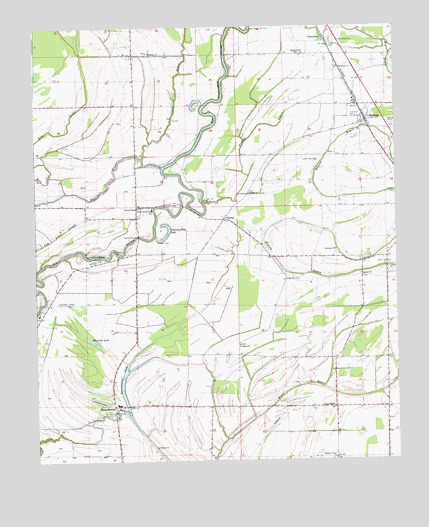
Mattson, MS USGS Topographic Map
Click on map above to begin viewing in our Map Viewer.

This topographic map contains these locations and features:
Feature Name Type Latitude Longitude GNIS ID View Map
Adams ChapelChurchN34.1171°W90.5315°666154View Map
Antioch ChurchChurchN34.0529°W90.5118°666328View Map
Bethel ChurchChurchN34.0771°W90.5507°666949View Map
Black Hill School (historical)SchoolN34.0301°W90.5040°689216View Map
Bobo LakeLakeN34.1112°W90.6070°689218View Map
Carr ChapelChurchN34.0740°W90.5790°668090View Map
Cherry Hill CemeteryCemeteryN34.0562°W90.5026°668372View Map
Cherry Hill Church (historical)ChurchN34.0565°W90.5037°689228View Map
ClaremontPopulated PlaceN34.1207°W90.5240°668499View Map
Clark BayouStreamN34.0871°W90.5876°668503View Map
CountsPopulated PlaceN34.0696°W90.5598°668862View Map
Dulaney-Ross LakeLakeN34.0656°W90.5791°669492View Map
Fairview ChurchChurchN34.0604°W90.5212°669889View Map
Fishing BayouStreamN34.0746°W90.5670°670000View Map
Galilee Church (historical)ChurchN34.0057°W90.5995°689265View Map
Harris BayouStreamN34.0846°W90.5807°670967View Map
Harvey ChapelChurchN34.0729°W90.5895°670998View Map
Hickory Grove ChurchChurchN34.0007°W90.5220°671167View Map
Hilliard School (historical)SchoolN34.0432°W90.5029°689274View Map
Johnson CemeteryCemeteryN34.0601°W90.5976°671926View Map
Marby Chapel (historical)ChurchN34.0582°W90.5282°689303View Map
MattsonPopulated PlaceN34.0979°W90.5101°673246View Map
Mount Horeb CemeteryCemeteryN34.1207°W90.5190°674034View Map
Mount Horeb ChurchChurchN34.1129°W90.5195°674037View Map
Mount Olive ChurchChurchN34.0523°W90.5379°674158View Map
Oak Grove Church (historical)ChurchN34.1101°W90.5901°689324View Map
Olive Branch School (historical)SchoolN34.0884°W90.5704°689327View Map
Plummer LakeLakeN34.0346°W90.6054°676154View Map
Robinson CemeteryCemeteryN34.0582°W90.6020°676727View Map
Rosenwald School (historical)SchoolN34.0307°W90.5470°689340View Map
Ross Church (historical)ChurchN34.0829°W90.5829°689341View Map
RoundawayPopulated PlaceN34.0143°W90.5982°676917View Map
Roundaway Elementary SchoolSchoolN34.0723°W90.5843°711545View Map
Roundaway LakeLakeN34.0229°W90.5951°676921View Map
RucksPopulated PlaceN34.0834°W90.5468°689342View Map
Russell CemeteryCemeteryN34.0632°W90.5826°676967View Map
Saint Marys ChurchChurchN34.0334°W90.5545°677157View Map
Sentry Mount Church (historical)ChurchN34.1032°W90.6179°689350View Map
Sunflower School (historical)SchoolN34.0426°W90.6240°689360View Map
Sunshine ChurchChurchN34.1176°W90.5854°678438View Map
Sunshine School (historical)SchoolN34.1173°W90.5848°689362View Map
Supervisor District 4CivilN34.0559°W90.5369°711826View Map
Traynham (historical)LocaleN34.0704°W90.5668°689370View Map
True Vine CemeteryCemeteryN34.0990°W90.5134°678901View Map
Union ChapelChurchN34.0154°W90.5223°679042View Map
Williams Chapel (historical)ChurchN34.0254°W90.5212°689376View Map
Willis Store (historical)LocaleN34.0154°W90.5215°689378View Map

Note: Coordinates in the location and feature list above are referenced to NAD83 datum.


Copyright (C) 2008-2024 Ryan Niemi / Sunset Dynamics ... All Rights Reserved