TopoQuest Logo
Do you find TopoQuest useful?
Help keep TopoQuest running and adding new maps/features by donating!
Bitcoin:  19c7KJd3qBynnjoSw5npx9KScwjBe4ifkT
Litecoin:  LXs6TkuXGGXo1vDsWCkWVdjQX94eUKd6ui
Home View Maps Find Maps Find Places Resources & Links


Matherville, Mississippi Topographic Map

USGS Map Title: Matherville, MS
USGS Map MRC: 31088G5
DRG (GeoTIFF) Download: o31088g5.tif


Neighboring USGS Topographic Map Quads:


  De Soto, MS  
31088H6
 

  Carmichael, MS  
31088H5
 

  Melvin, AL  
31088H4
 

  Shubuta, MS  
31088G6
 

  Matherville, MS  
31088G5
 

  Isney, AL  
31088G4
 

  Waynesboro, MS  
31088F6
 

  Denham, MS  
31088F5
 

  Aquilla, AL  
31088F4


Map MRC Location:

N32°
W89°
N32°
W88°
H8 H7 H6 H5 H4 H3 H2 H1
G8 G7 G6 G5 G4 G3 G2 G1
F8 F7 F6 F5 F4 F3 F2 F1
E8 E7 E6 E5 E4 E3 E2 E1
D8 D7 D6 D5 D4 D3 D2 D1
C8 C7 C6 C5 C4 C3 C2 C1
B8 B7 B6 B5 B4 B3 B2 B1
A8 A7 A6 A5 A4 A3 A2 A1
N31°
W89°
N31°
W88°

Matherville, MS USGS 1:24K Topographic Map Preview:
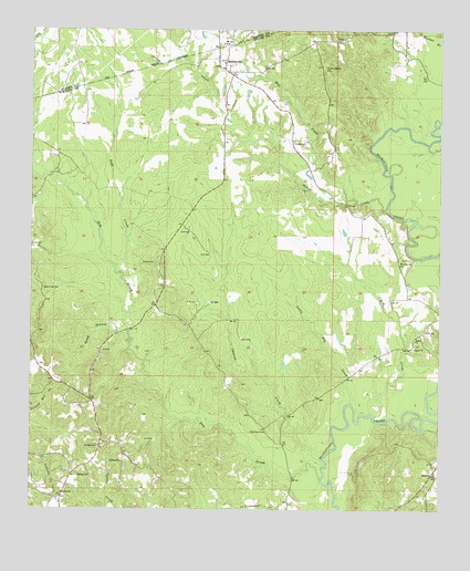
Matherville, MS USGS Topographic Map
Click on map above to begin viewing in our Map Viewer.

This topographic map contains these locations and features:
Feature Name Type Latitude Longitude GNIS ID View Map
Bethel ChurchChurchN31.7543°W88.6150°666911View Map
Billie Field CemeteryCemeteryN31.8077°W88.6214°667166View Map
Busby Game RefugeParkN31.7849°W88.5667°684063View Map
Coyt (historical)LocaleN31.8688°W88.5111°684071View Map
Cypress CreekStreamN31.7635°W88.5350°669046View Map
Cypress Oil FieldOilfieldN31.8043°W88.5667°706423View Map
Diamond (historical)LocaleN31.7779°W88.6050°706425View Map
Diamond School (historical)SchoolN31.7782°W88.6059°684075View Map
Dry CreekStreamN31.7579°W88.5356°669431View Map
Enon Church (historical)ChurchN31.7790°W88.5528°684077View Map
Gandy CemeteryCemeteryN31.8143°W88.5870°670310View Map
Geneva Presbyterian ChurchChurchN31.8665°W88.5664°706430View Map
GretnaPopulated PlaceN31.7596°W88.5020°691910View Map
Hebron ChurchChurchN31.7590°W88.6064°671067View Map
Little Dry CreekStreamN31.7777°W88.5267°672603View Map
MathervillePopulated PlaceN31.8657°W88.5656°673234View Map
Matherville CemeteryCemeteryN31.8665°W88.5667°706435View Map
Mayfalfa Farm (historical)LocaleN31.8668°W88.5986°687534View Map
Mill CreekStreamN31.8307°W88.5284°673622View Map
Mount Levy CemeteryCemeteryN31.8710°W88.5673°709447View Map
Mount Levy ChurchChurchN31.8713°W88.5678°687540View Map
Mount Levy SchoolSchoolN31.8715°W88.5661°674048View Map
New Hope CemeteryCemeteryN31.7704°W88.5525°674657View Map
Olive Branch School (historical)SchoolN31.8046°W88.5870°684095View Map
Page CreekStreamN31.8104°W88.5964°675381View Map
Saint James Church (historical)ChurchN31.8724°W88.5306°684102View Map
Saint John ChurchChurchN31.7663°W88.6042°677050View Map
Saint Luke ChurchChurchN31.8149°W88.5123°677110View Map
Saint Lukes Church (historical)ChurchN31.7921°W88.5270°684104View Map
Saint Paul ChurchChurchN31.7627°W88.5967°677186View Map
Salem CemeteryCemeteryN31.7949°W88.5072°706446View Map
Salem ChurchChurchN31.7946°W88.5073°677273View Map
Sand BranchStreamN31.7938°W88.5945°677325View Map
Scotch Chapel CemeteryCemeteryN31.8654°W88.5353°677460View Map
Shiloh CreekStreamN31.8285°W88.5161°677710View Map
South Cypress Creek Oil FieldOilfieldN31.7704°W88.5500°706449View Map
Stagg CemeteryCemeteryN31.8460°W88.5445°678204View Map
Stagg Lake DamDamN31.8335°W88.5384°680909View Map
Tick CreekStreamN31.7746°W88.5203°678750View Map
Wayne County Volunteer Fire Department Matherville StationBuildingN31.8648°W88.5664°2667983View Map
Wolf CreekStreamN31.7813°W88.5003°129153View Map

Note: Coordinates in the location and feature list above are referenced to NAD83 datum.


Copyright (C) 2008-2024 Ryan Niemi / Sunset Dynamics ... All Rights Reserved