TopoQuest Logo
Do you find TopoQuest useful?
Help keep TopoQuest running and adding new maps/features by donating!
Bitcoin:  19c7KJd3qBynnjoSw5npx9KScwjBe4ifkT
Litecoin:  LXs6TkuXGGXo1vDsWCkWVdjQX94eUKd6ui
Home View Maps Find Maps Find Places Resources & Links


Maryville East, Missouri Topographic Map

USGS Map Title: Maryville East, MO
USGS Map MRC: 40094C7
DRG (GeoTIFF) Download: o40094c7.tif


Neighboring USGS Topographic Map Quads:


  Wilcox, MO  
40094D8
 

  Pickering, MO  
40094D7
 

  Parnell West, MO  
40094D6
 

  Maryville West, MO  
40094C8
 

  Maryville East, MO  
40094C7
 

  Ravenwood, MO  
40094C6
 

  Bolckow NW, MO  
40094B8
 

  Barnard, MO  
40094B7
 

  Guilford, MO  
40094B6


Map MRC Location:

N41°
W95°
N41°
W94°
H8 H7 H6 H5 H4 H3 H2 H1
G8 G7 G6 G5 G4 G3 G2 G1
F8 F7 F6 F5 F4 F3 F2 F1
E8 E7 E6 E5 E4 E3 E2 E1
D8 D7 D6 D5 D4 D3 D2 D1
C8 C7 C6 C5 C4 C3 C2 C1
B8 B7 B6 B5 B4 B3 B2 B1
A8 A7 A6 A5 A4 A3 A2 A1
N40°
W95°
N40°
W94°

Maryville East, MO USGS 1:24K Topographic Map Preview:
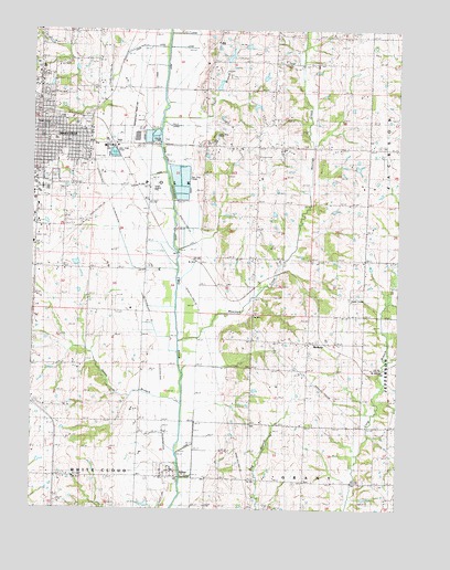
Maryville East, MO USGS Topographic Map
Click on map above to begin viewing in our Map Viewer.

This topographic map contains these locations and features:
Feature Name Type Latitude Longitude GNIS ID View Map
102 River Tributaries Watershed Number 13 DamDamN40.3700°W94.8019°760474View Map
102 River Tributaries Watershed Number 13 ReservoirReservoirN40.3708°W94.8020°760475View Map
102 River Tributaries Watershed Number 18 DamDamN40.3600°W94.8119°760734View Map
102 River Tributaries Watershed Number 21 DamDamN40.3633°W94.8086°760472View Map
102 River Tributaries Watershed Structure 23 DamDamN40.3550°W94.8002°760736View Map
102 River Tributaries Watershed Structure Number 16 DamDamN40.3667°W94.8086°762750View Map
102 River Tributaries Watershed Structure Number 22 DamDamN40.3617°W94.7969°760755View Map
102 River Tributaries Watershed Structure Number 4 DamDamN40.2917°W94.7836°761349View Map
102 Watershed Number 18 LakeReservoirN40.3605°W94.8116°760735View Map
ArkoePopulated PlaceN40.2580°W94.8277°713384View Map
BedisonPopulated PlaceN40.2933°W94.7744°740664View Map
Casteel School (historical)SchoolN40.3661°W94.7594°715477View Map
City of MaryvilleCivilN40.3438°W94.8705°2395037View Map
Council Corner School (historical)SchoolN40.3447°W94.7989°716379View Map
Douglas SchoolSchoolN40.3233°W94.7622°717012View Map
Elm Grove School (historical)SchoolN40.3667°W94.8614°717523View Map
Eugene Field Elementary SchoolSchoolN40.3463°W94.8678°2545210View Map
Hayden LakeReservoirN40.3641°W94.7782°761353View Map
Hayden Lake DamDamN40.3633°W94.7802°761352View Map
Highland School (historical)SchoolN40.3661°W94.8025°719583View Map
Hiley LakeReservoirN40.3626°W94.7959°760756View Map
Jones BranchStreamN40.2772°W94.8241°720401View Map
Jones Branch School (historical)SchoolN40.2800°W94.8380°720405View Map
Lochridge Farms LakeReservoirN40.3391°W94.7639°761348View Map
Lochridge Farms Lake DamDamN40.3400°W94.7652°761347View Map
Martha Washington School (historical)SchoolN40.3133°W94.8550°721911View Map
MaryvillePopulated PlaceN40.3461°W94.8725°721948View Map
Maryville Police DepartmentBuildingN40.3474°W94.8708°2752499View Map
Maryville Post OfficePost OfficeN40.3502°W94.8749°2782836View Map
Maryville Public Safety Fire DivisionBuildingN40.3473°W94.8709°2620659View Map
Maryville WaterworksReservoirN40.3466°W94.8337°761648View Map
Maryville WaterworksLocaleN40.3455°W94.8325°755307View Map
Maryville Waterworks DamDamN40.3467°W94.8336°761647View Map
Mires LakeReservoirN40.3627°W94.8073°760473View Map
Mitchell LakeReservoirN40.2917°W94.7836°761350View Map
Mount Ayr School (historical)SchoolN40.3161°W94.8025°722712View Map
Mozingo CreekStreamN40.2936°W94.8252°723006View Map
Number 23 LakeReservoirN40.3551°W94.7989°760737View Map
Oak Hill CemeteryCemeteryN40.3626°W94.8717°2702581View Map
Oak Hill Church (historical)ChurchN40.3447°W94.7830°723620View Map
Rankin AirportAirportN40.3332°W94.8352°758808View Map
Rose Hill School (historical)SchoolN40.2825°W94.7994°725571View Map
Saint Gregory Barbarigo SchoolSchoolN40.3428°W94.8652°2545394View Map
Schimming LakeReservoirN40.3679°W94.8080°762751View Map
Swinford SchoolSchoolN40.2614°W94.7583°727393View Map
Tallen AirportAirportN40.2703°W94.7858°758575View Map
Thill BranchStreamN40.3508°W94.8311°727571View Map
Town of ArkoeCivilN40.2596°W94.8291°2397438View Map
Township of PolkCivilN40.3525°W94.8646°767095View Map

Note: Coordinates in the location and feature list above are referenced to NAD83 datum.


Copyright (C) 2008-2024 Ryan Niemi / Sunset Dynamics ... All Rights Reserved