TopoQuest Logo
Do you find TopoQuest useful?
Help keep TopoQuest running and adding new maps/features by donating!
Bitcoin:  19c7KJd3qBynnjoSw5npx9KScwjBe4ifkT
Litecoin:  LXs6TkuXGGXo1vDsWCkWVdjQX94eUKd6ui
Home View Maps Find Maps Find Places Resources & Links


Marine, Illinois Topographic Map

USGS Map Title: Marine, IL
USGS Map MRC: 38089G7
DRG (GeoTIFF) Download: o38089g7.tif


Neighboring USGS Topographic Map Quads:


  Prairietown, IL  
38089H8
 

  Worden, IL  
38089H7
 

  New Douglas, IL  
38089H6
 

  Edwardsville, IL  
38089G8
 

  Marine, IL  
38089G7
 

  Grantfork, IL  
38089G6
 

  Collinsville, IL  
38089F8
 

  Saint Jacob, IL  
38089F7
 

  Highland, IL  
38089F6


Map MRC Location:

N39°
W90°
N39°
W89°
H8 H7 H6 H5 H4 H3 H2 H1
G8 G7 G6 G5 G4 G3 G2 G1
F8 F7 F6 F5 F4 F3 F2 F1
E8 E7 E6 E5 E4 E3 E2 E1
D8 D7 D6 D5 D4 D3 D2 D1
C8 C7 C6 C5 C4 C3 C2 C1
B8 B7 B6 B5 B4 B3 B2 B1
A8 A7 A6 A5 A4 A3 A2 A1
N38°
W90°
N38°
W89°

Marine, IL USGS 1:24K Topographic Map Preview:
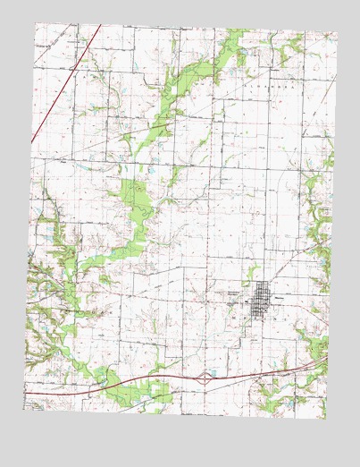
Marine, IL USGS Topographic Map
Click on map above to begin viewing in our Map Viewer.

This topographic map contains these locations and features:
Feature Name Type Latitude Longitude GNIS ID View Map
Bonn School (historical)SchoolN38.8309°W89.7643°1812165View Map
Columbia SchoolSchoolN38.8525°W89.8434°406401View Map
Columbia School (historical)SchoolN38.8523°W89.8437°1812177View Map
Crandall Family CemeteryCemeteryN38.8203°W89.7606°423437View Map
Daugherty CemeteryCemeteryN38.7887°W89.8706°423435View Map
First Christian Church of MarineChurchN38.7853°W89.7793°423430View Map
FruitPopulated PlaceN38.8309°W89.8626°422717View Map
Grigsby LakeReservoirN38.8288°W89.8533°1692309View Map
Grigsby Lake DamDamN38.8284°W89.8518°1692308View Map
Immanuel ChurchChurchN38.8692°W89.8562°410790View Map
Immanuel United Church of Christ CemeteryCemeteryN38.8696°W89.8560°2045078View Map
Interchange 21CrossingN38.7617°W89.8007°1812260View Map
KaufmanPopulated PlaceN38.8625°W89.7773°422858View Map
Keeven LakeReservoirN38.7650°W89.7851°1692311View Map
Keeven Lake DamDamN38.7650°W89.7851°1692310View Map
Loos SchoolSchoolN38.7950°W89.8220°412631View Map
Loos School (historical)SchoolN38.7950°W89.8220°1812290View Map
MarinePopulated PlaceN38.7864°W89.7776°413002View Map
Marine City ParkParkN38.7898°W89.7773°423427View Map
Marine Community Fire Protection DistrictBuildingN38.7848°W89.7763°2640807View Map
Marine Post OfficePost OfficeN38.7881°W89.7770°1812301View Map
Marine SchoolSchoolN38.7873°W89.7854°423429View Map
Marine United Church of ChristChurchN38.7870°W89.7768°423431View Map
Marine Village Police DepartmentBuildingN38.7896°W89.7788°2758933View Map
Mount Zion School (historical)SchoolN38.7928°W89.8648°1812313View Map
Neudeckers MountainSummitN38.7898°W89.7940°414371View Map
Oak Brook Golf CourseLocaleN38.8334°W89.8334°423433View Map
Saint Elizabeth Catholic CemeteryCemeteryN38.7603°W89.7754°413004View Map
Saint Elizabeths Catholic ChurchChurchN38.7878°W89.7826°423432View Map
Seibert School (historical)SchoolN38.8414°W89.7968°1812356View Map
Seybert Family CemeteryCemeteryN38.8412°W89.7965°423436View Map
Sportsman LakeReservoirN38.7548°W89.7647°418915View Map
Sylvan Hill School (historical)SchoolN38.7589°W89.8454°1812363View Map
Township of AlhambraCivilN38.8736°W89.7616°428579View Map
Township of MarineCivilN38.7861°W89.7625°429323View Map
Township of Pin OakCivilN38.7877°W89.8726°429570View Map
Union Grove SchoolSchoolN38.8189°W89.8645°420080View Map
Union Grove School (historical)SchoolN38.8187°W89.8640°1812368View Map
Village of MarineCivilN38.7871°W89.7781°2399256View Map
Willaredt LakeReservoirN38.8055°W89.8663°1691172View Map
Willaredt Lake DamDamN38.8050°W89.8651°1691171View Map
Wood Family CemeteryCemeteryN38.8589°W89.7995°423434View Map

Note: Coordinates in the location and feature list above are referenced to NAD83 datum.


Copyright (C) 2008-2024 Ryan Niemi / Sunset Dynamics ... All Rights Reserved