TopoQuest Logo
Do you find TopoQuest useful?
Help keep TopoQuest running and adding new maps/features by donating!
Bitcoin:  19c7KJd3qBynnjoSw5npx9KScwjBe4ifkT
Litecoin:  LXs6TkuXGGXo1vDsWCkWVdjQX94eUKd6ui
Home View Maps Find Maps Find Places Resources & Links


Mansfield Dam, Texas Topographic Map

USGS Map Title: Mansfield Dam, TX
USGS Map MRC: 30097D8
DRG (GeoTIFF) Download: o30097d8.tif


Neighboring USGS Topographic Map Quads:


  Travis Peak, TX  
30098E1
 

  Nameless, TX  
30097E8
 

  Leander, TX  
30097E7
 

  Pace Bend, TX  
30098D1
 

  Mansfield Dam, TX  
30097D8
 

  Jollyville, TX  
30097D7
 

  Shingle Hills, TX  
30098C1
 

  Bee Cave, TX  
30097C8
 

  Austin West, TX  
30097C7


Map MRC Location:

N31°
W98°
N31°
W97°
H8 H7 H6 H5 H4 H3 H2 H1
G8 G7 G6 G5 G4 G3 G2 G1
F8 F7 F6 F5 F4 F3 F2 F1
E8 E7 E6 E5 E4 E3 E2 E1
D8 D7 D6 D5 D4 D3 D2 D1
C8 C7 C6 C5 C4 C3 C2 C1
B8 B7 B6 B5 B4 B3 B2 B1
A8 A7 A6 A5 A4 A3 A2 A1
N30°
W98°
N30°
W97°

Mansfield Dam, TX USGS 1:24K Topographic Map Preview:
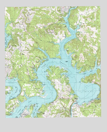
Mansfield Dam, TX USGS Topographic Map
Click on map above to begin viewing in our Map Viewer.

This topographic map contains these locations and features:
Feature Name Type Latitude Longitude GNIS ID View Map
Anderson BendBendN30.3891°W97.9939°1351092View Map
Apache LakeReservoirN30.3841°W97.9215°1862756View Map
Apache Lake DamDamN30.3835°W97.9220°1862755View Map
Arkansas BendBendN30.4074°W97.9608°1351247View Map
Arkansas Bend ParkParkN30.4010°W97.9517°2028907View Map
Arkansas Bend TrailTrailN30.4049°W97.9520°2032995View Map
Arrowhead PointCapeN30.4252°W97.9036°1351277View Map
Austin / Travis County Emergency Medical Service - Medic 25BuildingN30.4926°W97.9225°2655824View Map
Bald MountainSummitN30.4469°W97.9786°1351455View Map
Bar K ParkParkN30.4674°W97.9964°2028811View Map
Barrel HollowValleyN30.4649°W97.9195°1351537View Map
Beacon CoveBayN30.4221°W97.9178°1351634View Map
Bear CreekStreamN30.3846°W97.9136°1351672View Map
Bob Wentz - Windy Point ParkParkN30.4152°W97.8992°2028757View Map
Buffalo GapPopulated PlaceN30.3808°W97.9520°1353201View Map
Calcasieu PointCapeN30.4094°W97.9886°1353533View Map
City of JonestownCivilN30.4754°W97.9294°2410148View Map
City of Lago VistaCivilN30.4521°W97.9910°2411594View Map
Collier HollowValleyN30.4876°W97.9234°1354792View Map
Comanche PeakSummitN30.4010°W97.8750°1354832View Map
Cottonwood HollowsValleyN30.4277°W97.9606°1355124View Map
Cox HollowValleyN30.4197°W97.9850°1355253View Map
Cunningham CoveBayN30.4119°W97.9503°1355476View Map
Cypress Creek ArmBayN30.4263°W97.8892°1355518View Map
Dave Reed ParkParkN30.4663°W97.9231°2028470View Map
Defeat HollowValleyN30.3966°W97.8819°1355875View Map
Devils HollowValleyN30.4427°W97.9428°1355965View Map
Edgewater BeachPopulated PlaceN30.4033°W97.9989°1356820View Map
First Baptist Church - JonestownChurchN30.4899°W97.9258°2024607View Map
Fisher HollowValleyN30.4817°W97.9004°1357363View Map
Fritz Hughes ParkParkN30.3824°W97.9128°2028338View Map
Gragg HollowValleyN30.4812°W97.9243°1358243View Map
Graveyard PointCapeN30.3896°W97.9611°1358343View Map
Gun HollowValleyN30.4297°W97.9085°1358521View Map
Hatter CoveBayN30.4180°W97.9611°1358898View Map
Hippie Hollow ParkParkN30.4130°W97.8833°2029793View Map
Hudson BendPopulated PlaceN30.4171°W97.9292°1852714View Map
Hudson BendBendN30.4219°W97.9317°1359775View Map
Hudson Bend Census Designated PlaceCensusN30.4139°W97.9279°2408404View Map
Hurst Creek ArmBayN30.3821°W97.9614°1374184View Map
JonestownPopulated PlaceN30.4955°W97.9233°1360424View Map
Jonestown Municipal OfficesBuildingN30.4929°W97.9212°2753726View Map
KHFI-FM (Georgetown)TowerN30.4883°W97.8897°1385864View Map
Lago VistaPopulated PlaceN30.4602°W97.9883°1360825View Map
Lago Vista City HallBuildingN30.4530°W97.9874°2753287View Map
Lago Vista High SchoolSchoolN30.4813°W97.9783°2009134View Map
Lago Vista Middle SchoolSchoolN30.4733°W97.9736°2009135View Map
Lago Vista Police DepartmentBuildingN30.4728°W97.9909°2739318View Map
Lago Vista SchoolSchoolN30.4730°W97.9770°1360826View Map
Lago Vista StadiumParkN30.4783°W97.9789°2027763View Map
Lago Vista TX - Rusty Allen AirportAirportN30.4986°W97.9695°1387035View Map
Lake TravisReservoirN30.3919°W97.9067°1377192View Map
Lakeshore RanchLocaleN30.4283°W97.9592°1360875View Map
Lakeview ChurchChurchN30.4344°W97.8942°1360883View Map
Laura Reed ParkParkN30.4777°W97.9206°2028913View Map
Lime CreekStreamN30.4788°W97.9028°1361201View Map
Little Devils HollowValleyN30.4420°W97.9442°1361334View Map
Long HollowValleyN30.4569°W97.9274°1361733View Map
Long HollowValleyN30.4979°W97.8784°1361741View Map
Long Hollow CreekStreamN30.4327°W97.8811°1374706View Map
Macks CanyonValleyN30.4265°W97.9045°1362044View Map
Mansfield DamDamN30.3918°W97.9073°1362147View Map
Mansfield Dam Recreation ParkParkN30.3958°W97.9075°2029869View Map
Marshall FordPopulated PlaceN30.3919°W97.8886°1362202View Map
Mossy HollowValleyN30.4360°W97.9528°1363207View Map
North Lake Travis Fire and Rescue Station 101BuildingN30.4926°W97.9219°2552623View Map
North Lake Travis Fire and Rescue Station 104BuildingN30.4526°W97.9865°2552628View Map
North Lake Travis Fire and Rescue Station 105BuildingN30.3824°W97.9982°2552619View Map
North Lake Travis Fire and Rescue Station 106BuildingN30.4794°W97.9093°2552255View Map
North Shore AcresPopulated PlaceN30.4152°W97.9628°1364133View Map
Northwest Travis DivisionCivilN30.4794°W97.9401°1939269View Map
Point VenturePopulated PlaceN30.3794°W97.9961°1934754View Map
Pool CanyonValleyN30.4244°W97.9178°1375526View Map
Pool PointCapeN30.4177°W97.9856°1365574View Map
Rolling Hills Community ChurchChurchN30.4563°W97.9786°2024379View Map
Saint Lukes ChurchChurchN30.3935°W97.8750°1367234View Map
Sandy Creek ArmBayN30.4971°W97.9133°1367721View Map
Sandy Creek ParkParkN30.4688°W97.9067°2029347View Map
Simpson CemeteryCemeteryN30.4134°W97.9694°1368307View Map
South Jonestown ChurchChurchN30.4813°W97.9428°1368702View Map
South Jonestown HillsPopulated PlaceN30.4696°W97.9381°1368703View Map
Starnes IslandIslandN30.4383°W97.9211°1369128View Map
Steiner Ranch Elementary SchoolSchoolN30.3791°W97.8841°2009346View Map
Teck CemeteryCemeteryN30.3908°W97.9408°1369676View Map
Three PointsLocaleN30.4119°W97.9261°1369885View Map
Tom Hughes ParkParkN30.3974°W97.8803°2030037View Map
Travis County Emergency Services District 6 Station 1BuildingN30.3925°W97.9347°2655813View Map
Travis County Emergency Services District 6 Station 1 Hudson BendBuildingN30.3927°W97.9347°2552511View Map
Travis County Sheriff's Office West CommandBuildingN30.4098°W97.9456°2739425View Map
Travis Oaks Baptist ChurchChurchN30.4335°W97.9822°2024544View Map
Village of VolenteCivilN30.4453°W97.9079°2413598View Map
VolentePopulated PlaceN30.4338°W97.9036°1370679View Map
Volente Village OfficeBuildingN30.4418°W97.9122°2753333View Map
Volente Volunteer Fire DepartmentBuildingN30.4357°W97.9039°2552283View Map
West Beach CoveBayN30.4294°W97.9420°1371065View Map
Windy PointCapeN30.4152°W97.9008°1371794View Map
Winns HeliportAirportN30.4013°W97.9603°1386962View Map

Note: Coordinates in the location and feature list above are referenced to NAD83 datum.


Copyright (C) 2008-2024 Ryan Niemi / Sunset Dynamics ... All Rights Reserved