TopoQuest Logo
Do you find TopoQuest useful?
Help keep TopoQuest running and adding new maps/features by donating!
Bitcoin:  19c7KJd3qBynnjoSw5npx9KScwjBe4ifkT
Litecoin:  LXs6TkuXGGXo1vDsWCkWVdjQX94eUKd6ui
Home View Maps Find Maps Find Places Resources & Links


Bayou Sorrel, Louisiana Topographic Map

USGS Map Title: Bayou Sorrel, LA
USGS Map MRC: 30091B3
DRG (GeoTIFF) Download: o30091b3.tif


Neighboring USGS Topographic Map Quads:


  Grosse Tete SW, LA  
30091C4
 

  Addis, LA  
30091C3
 

  Plaquemine, LA  
30091C2
 

  Grand River, LA  
30091B4
 

  Bayou Sorrel, LA  
30091B3
 

  White Castle, LA  
30091B2
 

  Lake Chicot, LA  
30091A4
 

  Pigeon, LA  
30091A3
 

  Lone Star, LA  
30091A2


Map MRC Location:

N31°
W92°
N31°
W91°
H8 H7 H6 H5 H4 H3 H2 H1
G8 G7 G6 G5 G4 G3 G2 G1
F8 F7 F6 F5 F4 F3 F2 F1
E8 E7 E6 E5 E4 E3 E2 E1
D8 D7 D6 D5 D4 D3 D2 D1
C8 C7 C6 C5 C4 C3 C2 C1
B8 B7 B6 B5 B4 B3 B2 B1
A8 A7 A6 A5 A4 A3 A2 A1
N30°
W92°
N30°
W91°

Bayou Sorrel, LA USGS 1:24K Topographic Map Preview:
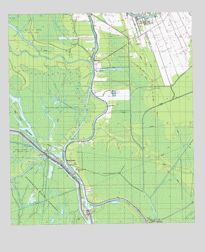
Bayou Sorrel, LA USGS Topographic Map
Click on map above to begin viewing in our Map Viewer.

This topographic map contains these locations and features:
Feature Name Type Latitude Longitude GNIS ID View Map
Bayou FarmerStreamN30.2308°W91.3287°532590View Map
Bayou GoulaGutN30.1635°W91.2607°532611View Map
Bayou JacobStreamN30.2483°W91.2776°532636View Map
Bayou PlaquemineStreamN30.2194°W91.3182°558160View Map
Bayou Plaquemine Baptist ChurchChurchN30.2163°W91.3159°558161View Map
Bayou RichardStreamN30.2233°W91.3182°558164View Map
Bayou SorrelStreamN30.1649°W91.3521°532779View Map
Bayou SorrelPopulated PlaceN30.1619°W91.3357°542965View Map
Bayou Sorrel Baptist ChurchChurchN30.1566°W91.3365°542777View Map
Bayou Sorrel Boat LandingLocaleN30.1646°W91.3484°542780View Map
Bayou Sorrel Fire DepartmentBuildingN30.1599°W91.3340°2332513View Map
Bayou Sorrel LocksDamN30.1333°W91.3232°553527View Map
Bayou Sorrel ParkParkN30.1566°W91.3296°542781View Map
Beam of Life ChurchChurchN30.1605°W91.3343°542770View Map
Big IslandIslandN30.1930°W91.3718°533083View Map
Bull Tail Bayou Oil FieldOilfieldN30.2399°W91.3584°542779View Map
C M Zito Multipurpose CenterBuildingN30.2455°W91.2755°2601304View Map
ChoctawPopulated PlaceN30.1263°W91.2765°543083View Map
CrescentPopulated PlaceN30.2477°W91.2873°558201View Map
Crescent Census Designated PlaceCensusN30.2406°W91.2863°2586675View Map
Crescent Elementary and Junior High SchoolSchoolN30.2481°W91.2936°557114View Map
Crescent Oil FieldOilfieldN30.2255°W91.2984°534243View Map
Cross BayouStreamN30.1983°W91.3726°534282View Map
Faith Tabernacle ChurchChurchN30.1677°W91.3512°542772View Map
Freeman Landing StripAirportN30.2316°W91.2846°557061View Map
Grand River ChurchChurchN30.1946°W91.3071°535347View Map
Grand River Gas FieldOilfieldN30.2066°W91.3379°557135View Map
Gulf Intracoastal WaterwayChannelN30.1777°W91.3190°1629293View Map
Indian Mound CemeteryCemeteryN30.1662°W91.3523°535927View Map
Jack Miller StoreLocaleN30.2183°W91.3171°542221View Map
Lake LongLakeN30.1269°W91.2794°555159View Map
Little IslandIslandN30.1799°W91.3615°536565View Map
Middle LakeLakeN30.2471°W91.3746°555306View Map
Mound BayouGutN30.1527°W91.3526°537271View Map
Mound DitchCanalN30.1741°W91.3568°537279View Map
Mount Airy Baptist ChurchChurchN30.2458°W91.2865°542776View Map
Mount Cyrene Baptist ChurchChurchN30.2435°W91.2809°542774View Map
Mount Zion Baptist ChurchChurchN30.2480°W91.2754°542773View Map
Mount Zion ChurchChurchN30.2477°W91.2757°557163View Map
Murrell CanalCanalN30.1646°W91.2587°537499View Map
New Hope Assembly of God ChurchChurchN30.2444°W91.2834°542775View Map
Parish Governing Authority District 10CivilN30.2048°W91.2872°1929782View Map
Pat BayBayN30.1980°W91.3690°538004View Map
Saint Ann ChurchChurchN30.2491°W91.2934°557192View Map
Saint Catherine Laboure ChurchChurchN30.1571°W91.3212°542771View Map
Salt Mine BayouStreamN30.1363°W91.3654°539110View Map
Sullivan LakeLakeN30.1934°W91.3386°556162View Map
Sullivan Lake Oil and Gas FieldOilfieldN30.1885°W91.3407°558325View Map
The BrakesLakeN30.2416°W91.3404°556225View Map
The ParksPopulated PlaceN30.2216°W91.3168°558332View Map
Upper Grand RiverStreamN30.2191°W91.3184°1628407View Map
Ward EightCivilN30.2321°W91.3618°545055View Map
White Castle Oil FieldOilfieldN30.1691°W91.3676°542778View Map
Wilberts CanalCanalN30.2105°W91.2926°1630023View Map
Willow LakeLakeN30.2021°W91.3409°556433View Map
Wiseman DitchCanalN30.2074°W91.3248°540507View Map

Note: Coordinates in the location and feature list above are referenced to NAD83 datum.


Copyright (C) 2008-2024 Ryan Niemi / Sunset Dynamics ... All Rights Reserved