TopoQuest Logo
Do you find TopoQuest useful?
Help keep TopoQuest running and adding new maps/features by donating!
Bitcoin:  19c7KJd3qBynnjoSw5npx9KScwjBe4ifkT
Litecoin:  LXs6TkuXGGXo1vDsWCkWVdjQX94eUKd6ui
Home View Maps Find Maps Find Places Resources & Links


Manilla, Indiana Topographic Map

USGS Map Title: Manilla, IN
USGS Map MRC: 39085E5
DRG (GeoTIFF) Download: o39085e5.tif


Neighboring USGS Topographic Map Quads:


  Morristown, IN  
39085F6
 

  Carthage, IN  
39085F5
 

  Mays, IN  
39085F4
 

  Rays Crossing, IN  
39085E6
 

  Manilla, IN  
39085E5
 

  Rushville, IN  
39085E4
 

  Waldron, IN  
39085D6
 

  Adams, IN  
39085D5
 

  Milroy, IN  
39085D4


Map MRC Location:

N40°
W86°
N40°
W85°
H8 H7 H6 H5 H4 H3 H2 H1
G8 G7 G6 G5 G4 G3 G2 G1
F8 F7 F6 F5 F4 F3 F2 F1
E8 E7 E6 E5 E4 E3 E2 E1
D8 D7 D6 D5 D4 D3 D2 D1
C8 C7 C6 C5 C4 C3 C2 C1
B8 B7 B6 B5 B4 B3 B2 B1
A8 A7 A6 A5 A4 A3 A2 A1
N39°
W86°
N39°
W85°

Manilla, IN USGS 1:24K Topographic Map Preview:
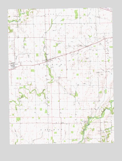
Manilla, IN USGS Topographic Map
Click on map above to begin viewing in our Map Viewer.

This topographic map contains these locations and features:
Feature Name Type Latitude Longitude GNIS ID View Map
Arbuckle DitchCanalN39.6045°W85.5664°430233View Map
Beaver Meadow CreekStreamN39.6209°W85.6091°430682View Map
Bebout CemeteryCemeteryN39.5939°W85.5083°430685View Map
Bebout CreekStreamN39.5959°W85.5186°430686View Map
Big Flat Rock ChurchChurchN39.5192°W85.5350°431036View Map
Blue River ChurchChurchN39.6184°W85.6136°431245View Map
Bob CreekStreamN39.5248°W85.5230°431270View Map
Branan CreekStreamN39.5439°W85.5472°431441View Map
Deer CreekStreamN39.5595°W85.5722°433422View Map
Ditch CreekStreamN39.5850°W85.6050°433571View Map
Gates DitchCanalN39.6153°W85.5119°434993View Map
Goddard CemeteryCemeteryN39.5899°W85.5376°435147View Map
Goddard DitchCanalN39.5884°W85.5547°435148View Map
Gordon DitchCanalN39.6095°W85.5266°435219View Map
GowdyPopulated PlaceN39.5189°W85.5630°435248View Map
Green CemeteryCemeteryN39.6151°W85.5120°435391View Map
Hodge DitchCanalN39.6145°W85.5500°436267View Map
HomerPopulated PlaceN39.5781°W85.5780°436372View Map
Homer RunStreamN39.5803°W85.5719°436374View Map
Hurst CemeteryCemeteryN39.5614°W85.5650°436656View Map
Johnson DitchCanalN39.6220°W85.5255°437049View Map
Logan Nine Hundred Forty-Five DitchCanalN39.5662°W85.5091°438225View Map
ManillaPopulated PlaceN39.5742°W85.6194°438518View Map
Manilla Census Designated PlaceCensusN39.5727°W85.6220°2629874View Map
Manilla Elementary SchoolSchoolN39.5712°W85.6186°447132View Map
Manilla Volunteer Fire DepartmentBuildingN39.5711°W85.6176°2626590View Map
McCarty CemeteryCemeteryN39.5112°W85.5163°438786View Map
McCorkle QuarryMineN39.5008°W85.5444°2649587View Map
McGinnis DitchCanalN39.5389°W85.5819°438874View Map
Mud CreekStreamN39.5595°W85.5728°439808View Map
Ormes CemeteryCemeteryN39.5632°W85.5143°440703View Map
Radar - Bowman - Worland CemeteryCemeteryN39.5067°W85.5871°1984224View Map
Sells CemeteryCemeteryN39.5986°W85.5849°443211View Map
South CreekStreamN39.5639°W85.5753°443798View Map
Summer Post Office (historical)Post OfficeN39.6239°W85.6139°453043View Map
Township of WalkerCivilN39.5752°W85.5748°453969View Map
Webster AirportAirportN39.5759°W85.5845°2676887View Map

Note: Coordinates in the location and feature list above are referenced to NAD83 datum.


Copyright (C) 2008-2024 Ryan Niemi / Sunset Dynamics ... All Rights Reserved