TopoQuest Logo
Do you find TopoQuest useful?
Help keep TopoQuest running and adding new maps/features by donating!
Bitcoin:  19c7KJd3qBynnjoSw5npx9KScwjBe4ifkT
Litecoin:  LXs6TkuXGGXo1vDsWCkWVdjQX94eUKd6ui
Home View Maps Find Maps Find Places Resources & Links


Manchester, Georgia Topographic Map

USGS Map Title: Manchester, GA
USGS Map MRC: 32084G5
DRG (GeoTIFF) Download: o32084g5.tif


Neighboring USGS Topographic Map Quads:


  Warm Springs, GA  
32084H6
 

  Woodbury, GA  
32084H5
 

  Sunset Village, GA  
32084H4
 

  Shiloh, GA  
32084G6
 

  Manchester, GA  
32084G5
 

  Roland, GA  
32084G4
 

  Waverly Hall, GA  
32084F6
 

  Talbotton, GA  
32084F5
 

  Baldwinville, GA  
32084F4


Map MRC Location:

N33°
W85°
N33°
W84°
H8 H7 H6 H5 H4 H3 H2 H1
G8 G7 G6 G5 G4 G3 G2 G1
F8 F7 F6 F5 F4 F3 F2 F1
E8 E7 E6 E5 E4 E3 E2 E1
D8 D7 D6 D5 D4 D3 D2 D1
C8 C7 C6 C5 C4 C3 C2 C1
B8 B7 B6 B5 B4 B3 B2 B1
A8 A7 A6 A5 A4 A3 A2 A1
N32°
W85°
N32°
W84°

Manchester, GA USGS 1:24K Topographic Map Preview:
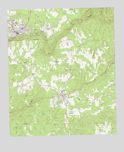
Manchester, GA USGS Topographic Map
Click on map above to begin viewing in our Map Viewer.

This topographic map contains these locations and features:
Feature Name Type Latitude Longitude GNIS ID View Map
BelleviewPopulated PlaceN32.7721°W84.5577°354535View Map
C & W Air ParkAirportN32.8448°W84.5492°2625407View Map
Callaway Public School (historical)SchoolN32.8557°W84.6121°346842View Map
Calvary Baptist ChurchChurchN32.8571°W84.6213°346843View Map
Chalybeate SpringsPopulated PlaceN32.8568°W84.5802°355102View Map
Church of ChristChurchN32.8518°W84.6160°346849View Map
Church of GodChurchN32.8632°W84.6199°346850View Map
Church of the NazareneChurchN32.8515°W84.6152°346851View Map
City of WoodlandCivilN32.7877°W84.5606°2405782View Map
Concord ChurchChurchN32.8104°W84.5094°355258View Map
Copeland LakeReservoirN32.8244°W84.5914°340592View Map
Copeland Lake DamDamN32.8235°W84.5916°340591View Map
Cunningham CrossroadsPopulated PlaceN32.8226°W84.5702°355408View Map
Dunn GapGapN32.8435°W84.5812°313730View Map
Evans ChapelChurchN32.8304°W84.5363°355731View Map
Fifth Avenue Shopping CenterLocaleN32.8554°W84.6194°346862View Map
First Methodist ChurchChurchN32.8507°W84.6138°346864View Map
First Presbyterian ChurchChurchN32.8524°W84.6171°346865View Map
Franklin Academy (historical)SchoolN32.8296°W84.5460°350817View Map
Georgia State Patrol Troop D Post 34 ManchesterBuildingN32.8454°W84.6213°2734071View Map
Gin CreekStreamN32.7546°W84.5638°314615View Map
Greens MillPopulated PlaceN32.7674°W84.5727°331866View Map
Hawkins CrossroadsPopulated PlaceN32.7618°W84.6083°326325View Map
Helm GapGapN32.7794°W84.6011°315307View Map
Hurricane BranchStreamN32.8735°W84.6038°315842View Map
Johnson GapGapN32.8455°W84.6203°316169View Map
Lazy Acres PlantationLocaleN32.8510°W84.5491°350820View Map
Mahone BranchStreamN32.7704°W84.5924°317632View Map
ManchesterPopulated PlaceN32.8599°W84.6199°317652View Map
Manchester Baptist ChurchChurchN32.8504°W84.6127°346882View Map
Manchester CemeteryCemeteryN32.8598°W84.6221°346883View Map
Manchester Christian AcademySchoolN32.8517°W84.6158°2545563View Map
Manchester Elementary SchoolSchoolN32.8596°W84.6130°346884View Map
Manchester Fire DepartmentBuildingN32.8603°W84.6163°2603801View Map
Manchester Grade School (historical)SchoolN32.8549°W84.6196°346885View Map
Manchester High SchoolSchoolN32.8592°W84.6189°346886View Map
Manchester Middle SchoolSchoolN32.8645°W84.6171°346887View Map
Manchester Police DepartmentBuildingN32.8517°W84.6145°2733693View Map
Manchester Post OfficePost OfficeN32.8521°W84.6144°346888View Map
Manchester Public School (historical)SchoolN32.8546°W84.6191°346889View Map
Meriwether County Training School (historical)SchoolN32.8582°W84.6227°346895View Map
Meriwether County Volunteer Fire Department Station 11BuildingN32.8598°W84.5802°2604549View Map
Milen GapGapN32.8504°W84.5896°318152View Map
Miller-Holmes CemeteryCemeteryN32.8296°W84.5338°350825View Map
Mitchell GapGapN32.8587°W84.5491°318343View Map
Mount Sinai Christian Methodist Episcopal ChurchChurchN32.8576°W84.6233°346900View Map
New Directions Alternative SchoolSchoolN32.8645°W84.6170°2545526View Map
Northside Baptist ChurchChurchN32.8546°W84.6046°346901View Map
Patrick GapGapN32.8635°W84.5366°320266View Map
Pine Mountain Foundation DamDamN32.8601°W84.5716°340212View Map
Pine Mountain Foundation LakeReservoirN32.8592°W84.5724°340213View Map
Pine Mountain Regional LibraryBuildingN32.8599°W84.6188°346907View Map
Rainbow FieldAirportN32.8338°W84.5380°2442661View Map
Ransome LakeLakeN32.7817°W84.5696°321314View Map
Reedy CemeteryCemeteryN32.7585°W84.6183°321447View Map
Rocky Shoals FordCrossingN32.7757°W84.5971°350837View Map
Rush CreekStreamN32.7837°W84.6063°322007View Map
Saint James Methodist ChurchChurchN32.8565°W84.6113°346916View Map
Stephenson GapGapN32.8307°W84.5785°323581View Map
Talbot County Fire Department Woodland StationBuildingN32.7841°W84.5602°2603862View Map
Tax CrossroadsPopulated PlaceN32.8118°W84.5983°333196View Map
Tom Brown BranchStreamN32.8690°W84.5435°324213View Map
Tom Brown SpringSpringN32.8740°W84.5474°324214View Map
Turkey KnobSummitN32.7843°W84.5971°333276View Map
Valley Grove Academy (historical)SchoolN32.8126°W84.5996°350851View Map
Valley Grove CemeteryCemeteryN32.8112°W84.5985°350852View Map
Valley Grove ChurchChurchN32.8129°W84.5999°324652View Map
Woodall SchoolSchoolN32.7757°W84.5535°325523View Map
WoodlandPopulated PlaceN32.7874°W84.5619°356649View Map
Woodland AcademySchoolN32.7854°W84.5605°350854View Map
Woodland DivisionCivilN32.7935°W84.5719°1936655View Map
Woodland LakeReservoirN32.7860°W84.5415°325534View Map
Woodland Lake DamDamN32.7860°W84.5413°340593View Map
Woodland Lookout TowerTowerN32.8204°W84.5044°344387View Map
Woodland Police DepartmentBuildingN32.7877°W84.5610°2733542View Map
Woodland School (historical)SchoolN32.7854°W84.5605°350855View Map
WVFJ-FM (Manchester)TowerN32.8446°W84.6235°352728View Map

Note: Coordinates in the location and feature list above are referenced to NAD83 datum.


Copyright (C) 2008-2024 Ryan Niemi / Sunset Dynamics ... All Rights Reserved