TopoQuest Logo
Do you find TopoQuest useful?
Help keep TopoQuest running and adding new maps/features by donating!
Bitcoin:  19c7KJd3qBynnjoSw5npx9KScwjBe4ifkT
Litecoin:  LXs6TkuXGGXo1vDsWCkWVdjQX94eUKd6ui
Home View Maps Find Maps Find Places Resources & Links


Macon East, Georgia Topographic Map

USGS Map Title: Macon East, GA
USGS Map MRC: 32083G5
DRG (GeoTIFF) Download: o32083g5.tif


Neighboring USGS Topographic Map Quads:


  Macon NW, GA  
32083H6
 

  Macon NE, GA  
32083H5
 

  James, GA  
32083H4
 

  Macon West, GA  
32083G6
 

  Macon East, GA  
32083G5
 

  Dry Branch, GA  
32083G4
 

  Warner Robins NW, GA  
32083F6
 

  Warner Robins NE, GA  
32083F5
 

  Marion, GA  
32083F4


Map MRC Location:

N33°
W84°
N33°
W83°
H8 H7 H6 H5 H4 H3 H2 H1
G8 G7 G6 G5 G4 G3 G2 G1
F8 F7 F6 F5 F4 F3 F2 F1
E8 E7 E6 E5 E4 E3 E2 E1
D8 D7 D6 D5 D4 D3 D2 D1
C8 C7 C6 C5 C4 C3 C2 C1
B8 B7 B6 B5 B4 B3 B2 B1
A8 A7 A6 A5 A4 A3 A2 A1
N32°
W84°
N32°
W83°

Macon East, GA USGS 1:24K Topographic Map Preview:
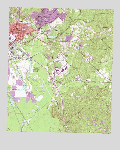
Macon East, GA USGS Topographic Map
Click on map above to begin viewing in our Map Viewer.

This topographic map contains these locations and features:
Feature Name Type Latitude Longitude GNIS ID View Map
Alexander SchoolSchoolN32.8501°W83.6232°310435View Map
Andrews CemeteryCemeteryN32.7697°W83.5547°310540View Map
Andrews HillSummitN32.7640°W83.5502°1672023View Map
Appling High SchoolSchoolN32.8604°W83.6030°1672026View Map
Baker LakeReservoirN32.8633°W83.5308°340767View Map
Baker Lake DamDamN32.8618°W83.5316°340766View Map
Belvedere ManorPopulated PlaceN32.8724°W83.5777°345331View Map
Bernd SchoolSchoolN32.8140°W83.5677°311108View Map
Black LakeLakeN32.8126°W83.5891°311486View Map
Boggy BranchStreamN32.8238°W83.5993°311607View Map
Bowden Golf CourseLocaleN32.8610°W83.5680°1672051View Map
BridgemanPopulated PlaceN32.8315°W83.5657°1672055View Map
Bristol ForestPopulated PlaceN32.8576°W83.5827°1672056View Map
Burdell SchoolSchoolN32.8532°W83.6127°312042View Map
Camp Hope CemeteryCemeteryN32.8671°W83.5774°312231View Map
Cauley LakeReservoirN32.8578°W83.5304°340151View Map
Cauley Lake DamDamN32.8568°W83.5316°340150View Map
Coliseum Center for Behavioral HealthHospitalN32.8472°W83.6198°2611006View Map
Coliseum Medical CenterHospitalN32.8473°W83.6186°1672080View Map
Conner ParkParkN32.8368°W83.6221°1672086View Map
Cross KeysPopulated PlaceN32.8521°W83.5880°331480View Map
Cross Keys Christian AcademySchoolN32.8526°W83.5849°1672091View Map
Crystal SpringsPopulated PlaceN32.8387°W83.5580°1672092View Map
Danforth SchoolSchoolN32.8576°W83.6016°1672095View Map
Dry Bone CreekStreamN32.8732°W83.6035°313634View Map
DuresvillePopulated PlaceN32.8601°W83.5785°1672101View Map
Duresville Church (historical)ChurchN32.8654°W83.5868°1672102View Map
Duresville SchoolSchoolN32.8612°W83.5763°313739View Map
East MaconPopulated PlaceN32.8368°W83.5602°1672104View Map
Edwards LakeReservoirN32.8096°W83.5542°313862View Map
Edwards Lake DamDamN32.8096°W83.5532°336175View Map
Exit 3CrossingN32.8432°W83.6235°1672109View Map
Exit 4CrossingN32.8396°W83.6193°1672111View Map
Faith ChurchChurchN32.8240°W83.5293°314059View Map
Fire Station Number 4BuildingN32.8349°W83.6243°1672119View Map
Fort Hawkins (historical)MilitaryN32.8492°W83.6119°1672127View Map
Fort Hawkins SchoolSchoolN32.8490°W83.6116°314293View Map
Fort Hill CemeteryCemeteryN32.8529°W83.6080°314292View Map
FranklintonPopulated PlaceN32.8043°W83.5355°331768View Map
Georgia Forestry CommissionBuildingN32.8078°W83.5398°2604986View Map
Georgia State FairgroundsParkN32.8340°W83.6121°1672132View Map
GrovelandPopulated PlaceN32.8710°W83.5846°1672144View Map
Hall BranchStreamN32.8010°W83.5318°315028View Map
Hall SchoolSchoolN32.8665°W83.5830°315042View Map
Heritage AcresPopulated PlaceN32.8682°W83.6238°1672151View Map
Highland HillsPopulated PlaceN32.8649°W83.6066°1672154View Map
Hunt SchoolSchoolN32.8604°W83.6080°315827View Map
Interchange 5CrossingN32.7999°W83.5693°1672112View Map
Jones County Shopping CenterLocaleN32.8732°W83.5599°345369View Map
Kings ParkPopulated PlaceN32.8454°W83.5527°1672183View Map
Lake ArrowheadReservoirN32.8624°W83.5598°1672028View Map
Lake ArrowheadPopulated PlaceN32.8668°W83.5610°1672184View Map
LakesidePopulated PlaceN32.8412°W83.5738°332169View Map
Lakeside DamDamN32.8468°W83.5782°336179View Map
Lakeside HillPopulated PlaceN32.8535°W83.5763°1672186View Map
Lakeside ParkParkN32.8487°W83.5718°1672187View Map
Lakeside ReservoirReservoirN32.8461°W83.5734°336180View Map
Lanier HeightsPopulated PlaceN32.8165°W83.5685°332184View Map
Lanier Heights ChurchChurchN32.8129°W83.5693°1672191View Map
Macon - Bibb County Fire Department Station 1BuildingN32.8460°W83.6165°2604250View Map
Macon - Bibb County Fire Department Station 101BuildingN32.8189°W83.5560°2604247View Map
Macon - Bibb County Fire Department Station 9BuildingN32.8655°W83.5837°2604244View Map
Macon Downtown AirportAirportN32.8257°W83.5661°351834View Map
Macon East DivisionCivilN32.8225°W83.5703°2583413View Map
Macon Police Department Precinct 1BuildingN32.8608°W83.5940°2734148View Map
McCrory School (historical)SchoolN32.8415°W83.5530°1672216View Map
MogulPopulated PlaceN32.8499°W83.5649°332406View Map
MorningsidePopulated PlaceN32.8507°W83.5777°1672227View Map
Mountain Springs CemeteryCemeteryN32.8562°W83.5029°345379View Map
Mountain Springs ChurchChurchN32.8562°W83.5055°319080View Map
Newcastle School (historical)SchoolN32.7751°W83.5607°1672234View Map
Northeast High SchoolSchoolN32.8665°W83.6210°1672238View Map
Northeast Plaza Shopping CenterLocaleN32.8440°W83.6110°1672239View Map
Ocmulgee ChurchChurchN32.7760°W83.5621°319892View Map
Ocmulgee National MonumentParkN32.8382°W83.6022°1888951View Map
Ocmulgee National MonumentPillarN32.8151°W83.5907°319893View Map
Saint Matthews ChurchChurchN32.8590°W83.6024°322224View Map
SandersPopulated PlaceN32.8243°W83.5996°1672278View Map
Sawyer LakeReservoirN32.8360°W83.5413°322613View Map
Sawyer Lake DamDamN32.8362°W83.5410°336177View Map
ShirlingtonPopulated PlaceN32.8612°W83.5888°1672287View Map
SmithsoniaPopulated PlaceN32.8035°W83.5682°333074View Map
Stone Creek CemeteryCemeteryN32.7950°W83.5106°323645View Map
Stone LakeReservoirN32.7882°W83.5668°336174View Map
Stone Lake DamDamN32.7885°W83.5682°336173View Map
Sunnydale AcresPopulated PlaceN32.8549°W83.5985°1672303View Map
Swift CreekStreamN32.7963°W83.5824°323843View Map
Swift Creek Baptist ChurchChurchN32.8310°W83.5374°1672304View Map
Swift Creek DivisionCensusN32.8076°W83.5566°1936569View Map
Swift Creek SchoolSchoolN32.8312°W83.5371°323850View Map
TanglewoodPopulated PlaceN32.8446°W83.5627°1672306View Map
TerrellPopulated PlaceN32.8143°W83.5188°1672311View Map
Thornton HeightsPopulated PlaceN32.8296°W83.5299°1672314View Map
Town and Country Shopping CenterLocaleN32.8543°W83.6188°1672315View Map
Union ChapelChurchN32.7790°W83.5635°324497View Map
Van Buren (historical)Populated PlaceN32.8724°W83.5402°345399View Map
Walker LakesReservoirN32.8054°W83.6109°1672333View Map
Walnut CreekStreamN32.8276°W83.6055°330148View Map
Walter P Jones Elementary SchoolSchoolN32.8657°W83.5957°1672335View Map
WAYS-FM (Macon)TowerN32.7529°W83.5588°352725View Map
WBML-AM (Macon)TowerN32.8496°W83.6021°352478View Map
Weaver HeightsPopulated PlaceN32.8682°W83.5721°1672339View Map
WGXA-TV (Macon)TowerN32.7524°W83.5605°352856View Map
Wheeler HeightsPopulated PlaceN32.8262°W83.5585°333403View Map
Whispering PinesPopulated PlaceN32.8440°W83.5402°1672351View Map
WIBB-AM (Macon)TowerN32.8046°W83.6043°352482View Map
WMAZ-TV (Macon)TowerN32.7529°W83.5588°352859View Map
WMGT-TV (Macon)TowerN32.7535°W83.5627°352857View Map
Wood ValleyPopulated PlaceN32.8715°W83.6163°1672361View Map
WPEZ-FM (Macon)TowerN32.7535°W83.5627°352726View Map

Note: Coordinates in the location and feature list above are referenced to NAD83 datum.


Copyright (C) 2008-2024 Ryan Niemi / Sunset Dynamics ... All Rights Reserved