TopoQuest Logo
Do you find TopoQuest useful?
Help keep TopoQuest running and adding new maps/features by donating!
Bitcoin:  19c7KJd3qBynnjoSw5npx9KScwjBe4ifkT
Litecoin:  LXs6TkuXGGXo1vDsWCkWVdjQX94eUKd6ui
Home View Maps Find Maps Find Places Resources & Links


Machias Bay, Maine Topographic Map

USGS Map Title: Machias Bay, ME
USGS Map MRC: 44067F3
DRG (GeoTIFF) Download: o44067f3.tif


Neighboring USGS Topographic Map Quads:


  Hadley Lake, ME  
44067G4
 

  Long Lake, ME  
44067G3
 

  Whiting, ME  
44067G2
 

  Machias, ME  
44067F4
 

  Machias Bay, ME  
44067F3
 

  Cutler, ME  
44067F2
 

  Roque Bluffs, ME  
44067E4
 

  Cross Island, ME  
44067E3
 

  Old Man, ME  
44067E2


Map MRC Location:

N45°
W68°
N45°
W67°
H8 H7 H6 H5 H4 H3 H2 H1
G8 G7 G6 G5 G4 G3 G2 G1
F8 F7 F6 F5 F4 F3 F2 F1
E8 E7 E6 E5 E4 E3 E2 E1
D8 D7 D6 D5 D4 D3 D2 D1
C8 C7 C6 C5 C4 C3 C2 C1
B8 B7 B6 B5 B4 B3 B2 B1
A8 A7 A6 A5 A4 A3 A2 A1
N44°
W68°
N44°
W67°

Machias Bay, ME USGS 1:24K Topographic Map Preview:
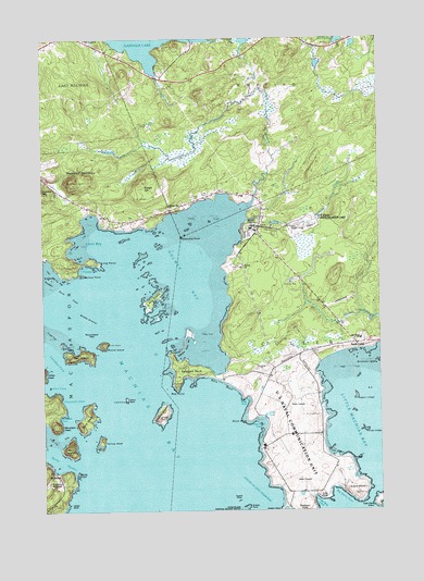
Machias Bay, ME USGS Topographic Map
Click on map above to begin viewing in our Map Viewer.

This topographic map contains these locations and features:
Feature Name Type Latitude Longitude GNIS ID View Map
Avery RockIslandN44.6542°W67.3442°581386View Map
Avery Rock Lighthouse (historical)LocaleN44.6542°W67.3430°1909056View Map
Bar IslandIslandN44.6409°W67.3655°561583View Map
Bare IslandIslandN44.6495°W67.3592°561596View Map
Bay Ridge Elementary SchoolSchoolN44.6704°W67.2571°1909063View Map
Big Holly CoveBayN44.6287°W67.2669°562179View Map
Bucks HarborBayN44.6395°W67.3733°563124View Map
Bucks HeadIslandN44.6348°W67.3625°563126View Map
Cape WashCapeN44.6298°W67.2589°563493View Map
Cape Wash IslandIslandN44.6279°W67.2505°563494View Map
Chance IslandIslandN44.6501°W67.3322°563814View Map
Clamshell CoveBayN44.6542°W67.3680°564015View Map
Colbeth RockIslandN44.6315°W67.3497°564168View Map
Cottage CoveBayN44.6890°W67.3592°564383View Map
Cutler Navy Fire DepartmentBuildingN44.7004°W67.2949°2552946View Map
Cutler Regional AirportAirportN44.6796°W67.2674°582137View Map
Davis BeachBeachN44.6592°W67.3105°564793View Map
Deep CoveBayN44.6537°W67.3008°564954View Map
Dogfish RocksIslandN44.6279°W67.3022°565175View Map
Enoch HillSummitN44.7125°W67.3368°565925View Map
Grassy PointCapeN44.6254°W67.3017°567081View Map
Great PondLakeN44.6501°W67.2928°567170View Map
Great Pond CoveBayN44.6467°W67.2961°567175View Map
Hog IslandIslandN44.6806°W67.3358°568163View Map
Holly PointCapeN44.6284°W67.2717°568198View Map
Holmes BayBayN44.6854°W67.3222°568201View Map
Holmes Bay ChurchChurchN44.7048°W67.3289°568202View Map
Holmes Bay SchoolSchoolN44.7090°W67.3130°568203View Map
Holmes PointCapeN44.6876°W67.3614°568213View Map
Holmes PondLakeN44.7493°W67.2993°568214View Map
Holmes StreamStreamN44.7062°W67.2980°568215View Map
Huntley CreekStreamN44.7023°W67.3000°568480View Map
Indian CoveBayN44.6581°W67.3736°568570View Map
Jasper BeachBeachN44.6273°W67.3675°1802600View Map
Jasper HeadCliffN44.6279°W67.3669°568773View Map
Larrabee CoveBayN44.6665°W67.3730°569389View Map
Little BayBayN44.6945°W67.3572°569667View Map
Little Holly CoveBayN44.6267°W67.2719°569827View Map
Little Machias BayBayN44.6487°W67.2578°569887View Map
Long LedgeBarN44.6459°W67.2553°570244View Map
Long PointCapeN44.6906°W67.3553°570265View Map
Look CemeteryCemeteryN44.7087°W67.3130°1909239View Map
Machias BayBayN44.6359°W67.3439°570614View Map
Middle GroundBarN44.6765°W67.3580°571242View Map
Mountain HeadSummitN44.6476°W67.3697°571806View Map
Naval Radio Station CutlerMilitaryN44.6508°W67.2910°2512344View Map
North CutlerPopulated PlaceN44.6692°W67.2594°579561View Map
Pettegrove MountainSummitN44.6312°W67.3717°581479View Map
Point RuthCapeN44.6490°W67.3000°573560View Map
Randall Point FlatsBarN44.6829°W67.3678°574032View Map
Red PointCapeN44.6573°W67.3258°574093View Map
Round IslandIslandN44.6679°W67.3444°574473View Map
Round Island FlatsBarN44.6720°W67.3542°574478View Map
Salt IslandIslandN44.6662°W67.3611°574790View Map
Sprague NeckCapeN44.6617°W67.3203°576077View Map
Sprague Neck BarBarN44.6701°W67.3230°576078View Map
Township RockIslandN44.6976°W67.3242°577250View Map
Upper LedgeBarN44.6548°W67.2589°577624View Map
Waleback CoveBayN44.6498°W67.3680°578294View Map
Windows LedgeBarN44.6642°W67.2519°578449View Map
Woodruff MountainSummitN44.7131°W67.3628°578689View Map
Yellow HeadIslandN44.6431°W67.3533°578750View Map

Note: Coordinates in the location and feature list above are referenced to NAD83 datum.


Copyright (C) 2008-2024 Ryan Niemi / Sunset Dynamics ... All Rights Reserved