TopoQuest Logo
Do you find TopoQuest useful?
Help keep TopoQuest running and adding new maps/features by donating!
Bitcoin:  19c7KJd3qBynnjoSw5npx9KScwjBe4ifkT
Litecoin:  LXs6TkuXGGXo1vDsWCkWVdjQX94eUKd6ui
Home View Maps Find Maps Find Places Resources & Links


Mabank, Texas Topographic Map

USGS Map Title: Mabank, TX
USGS Map MRC: 32096C1
DRG (GeoTIFF) Download: o32096c1.tif


Neighboring USGS Topographic Map Quads:


  Kemp, TX  
32096D2
 

  Prairieville, TX  
32096D1
 

  Phalba, TX  
32095D8
 

  Tool, TX  
32096C2
 

  Mabank, TX  
32096C1
 

  Stockard, TX  
32095C8
 

  Kerens, TX  
32096B2
 

  Malakoff, TX  
32096B1
 

  Mallard Hill, TX  
32095B8


Map MRC Location:

N33°
W97°
N33°
W96°
H8 H7 H6 H5 H4 H3 H2 H1
G8 G7 G6 G5 G4 G3 G2 G1
F8 F7 F6 F5 F4 F3 F2 F1
E8 E7 E6 E5 E4 E3 E2 E1
D8 D7 D6 D5 D4 D3 D2 D1
C8 C7 C6 C5 C4 C3 C2 C1
B8 B7 B6 B5 B4 B3 B2 B1
A8 A7 A6 A5 A4 A3 A2 A1
N32°
W97°
N32°
W96°

Mabank, TX USGS 1:24K Topographic Map Preview:
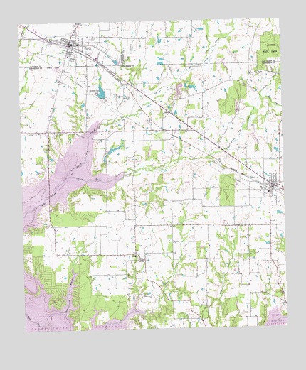
Mabank, TX USGS Topographic Map
Click on map above to begin viewing in our Map Viewer.

This topographic map contains these locations and features:
Feature Name Type Latitude Longitude GNIS ID View Map
Abernathy LakeReservoirN32.3459°W96.0493°1864414View Map
Abernathy Lake DamDamN32.3468°W96.0502°1864413View Map
Boulevard ParkParkN32.3624°W96.1058°2028769View Map
Cedar BranchStreamN32.2568°W96.1064°1372990View Map
Central Elementary SchoolSchoolN32.3660°W96.0977°2007031View Map
Church of the NazareneChurchN32.3346°W96.1147°2020994View Map
City of EustaceCivilN32.3075°W96.0138°2410466View Map
Dry CreekStreamN32.3565°W96.0394°1334680View Map
Elam Grove ChurchChurchN32.3532°W96.0930°1335295View Map
Enchanted OaksPopulated PlaceN32.2654°W96.1094°1388582View Map
Enchanted Oaks City HallBuildingN32.2634°W96.1099°2754019View Map
Enchanted Oaks Volunteer Fire DepartmentBuildingN32.2708°W96.1098°2655543View Map
EustacePopulated PlaceN32.3071°W96.0066°1373681View Map
Eustace Area Volunteer Fire DepartmentBuildingN32.3087°W96.0096°2655312View Map
Eustace Police DepartmentBuildingN32.3067°W96.0059°2751167View Map
Eustace Post OfficePost OfficeN32.3093°W96.0082°2731844View Map
First Baptist Church of MabankChurchN32.3674°W96.1008°2022673View Map
First Presbyterian Church of MabankChurchN32.3674°W96.1008°2022690View Map
Goshen CemeteryCemeteryN32.3529°W96.0114°1336743View Map
Gun Barrel City Fire DepartmentBuildingN32.3355°W96.1169°2655155View Map
Gun Barrel City Police DepartmentBuildingN32.3348°W96.1162°2751147View Map
John Santerre LakeReservoirN32.3218°W96.0836°1854702View Map
John Santerre Lake DamDamN32.3218°W96.0836°1854701View Map
Little Dry BranchStreamN32.3374°W96.0722°1340083View Map
MabankPopulated PlaceN32.3665°W96.1008°1340780View Map
Mabank CemeteryCemeteryN32.3574°W96.0786°1340781View Map
Mabank City HallBuildingN32.3663°W96.0996°2754032View Map
Mabank City LakeReservoirN32.3464°W96.0862°1340782View Map
Mabank City Lake DamDamN32.3435°W96.0852°1854703View Map
Mabank Fire Department Central Fire StationBuildingN32.3655°W96.0998°2551827View Map
Mabank High SchoolSchoolN32.3693°W96.1136°2007054View Map
Mabank Middle SchoolSchoolN32.3696°W96.1000°2007055View Map
Mabank Police DepartmentBuildingN32.3663°W96.0996°2738990View Map
Mabank Post OfficePost OfficeN32.3522°W96.1049°2732096View Map
Mason Ranch CemeteryCemeteryN32.3232°W96.1122°1341052View Map
Medical Emergency Gbc HeliportAirportN32.3347°W96.1131°1384802View Map
Mill CreekStreamN32.3440°W96.0105°1341627View Map
North Twin CreekStreamN32.3132°W96.1014°1342823View Map
PaulinePopulated PlaceN32.3379°W96.0539°1378839View Map
Payne SpringsPopulated PlaceN32.2782°W96.0669°1378841View Map
Payne Springs City HallBuildingN32.2787°W96.0701°2754033View Map
Payne Springs Fire Rescue Station 2BuildingN32.2788°W96.0694°2655311View Map
Purtis CreekStreamN32.3463°W96.0100°1344637View Map
Saint Peter Lutheran ChurchChurchN32.3093°W96.1211°2020998View Map
South Twin CreekStreamN32.3132°W96.1014°1347540View Map
Town of Enchanted OaksCivilN32.2666°W96.1090°2412487View Map
Town of MabankCivilN32.3683°W96.1137°2412931View Map
Town of Payne SpringsCivilN32.2721°W96.0872°2413120View Map

Note: Coordinates in the location and feature list above are referenced to NAD83 datum.


Copyright (C) 2008-2024 Ryan Niemi / Sunset Dynamics ... All Rights Reserved