TopoQuest Logo
Do you find TopoQuest useful?
Help keep TopoQuest running and adding new maps/features by donating!
Bitcoin:  19c7KJd3qBynnjoSw5npx9KScwjBe4ifkT
Litecoin:  LXs6TkuXGGXo1vDsWCkWVdjQX94eUKd6ui
Home View Maps Find Maps Find Places Resources & Links


Baxter Lake, New Hampshire Topographic Map

USGS Map Title: Baxter Lake, NH
USGS Map MRC: 43071C1
DRG (GeoTIFF) Download: o43071c1.tif


Neighboring USGS Topographic Map Quads:


  Alton, NH  
43071D2
 

  Farmington, NH  
43071D1
 

  Milton, NH  
43070D8
 

  Parker Mountain, NH  
43071C2
 

  Baxter Lake, NH  
43071C1
 

  Rochester, NH  
43070C8
 

  Northwood, NH  
43071B2
 

  Barrington, NH  
43071B1
 

  Dover West, NH  
43070B8


Map MRC Location:

N44°
W72°
N44°
W71°
H8 H7 H6 H5 H4 H3 H2 H1
G8 G7 G6 G5 G4 G3 G2 G1
F8 F7 F6 F5 F4 F3 F2 F1
E8 E7 E6 E5 E4 E3 E2 E1
D8 D7 D6 D5 D4 D3 D2 D1
C8 C7 C6 C5 C4 C3 C2 C1
B8 B7 B6 B5 B4 B3 B2 B1
A8 A7 A6 A5 A4 A3 A2 A1
N43°
W72°
N43°
W71°

Baxter Lake, NH USGS 1:24K Topographic Map Preview:
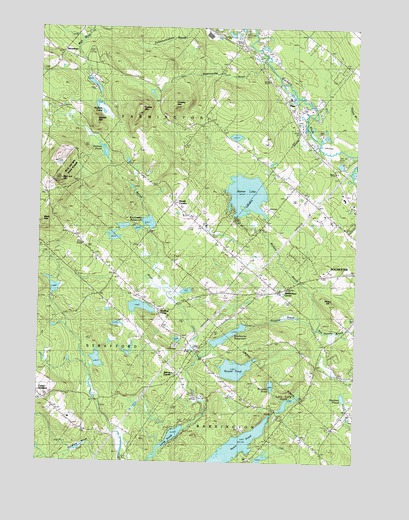
Baxter Lake, NH USGS Topographic Map
Click on map above to begin viewing in our Map Viewer.

This topographic map contains these locations and features:
Feature Name Type Latitude Longitude GNIS ID View Map
Academy for Equine Sciences Charter SchoolSchoolN43.3213°W71.0122°2499501View Map
Ayers PondReservoirN43.2548°W71.0454°865295View Map
Baxter LakeReservoirN43.3272°W71.0429°865418View Map
Baxter Lake Center DikeDamN43.3234°W71.0395°1775459View Map
Baxter Lake Easterly DikeDamN43.3217°W71.0345°1775455View Map
Baxter Lake Main DamDamN43.3201°W71.0445°1775461View Map
Berry Brook DamDamN43.3167°W71.0828°1775317View Map
Berrys CornerPopulated PlaceN43.2751°W71.0690°865559View Map
Berrys RiverStreamN43.2595°W71.0687°865561View Map
Berrys River DamDamN43.2717°W71.0628°1774991View Map
Berrys River ReservoirReservoirN43.3167°W71.0828°1775318View Map
Berrys River ReservoirReservoirN43.2704°W71.0626°1774992View Map
Blue Job MountainSummitN43.3315°W71.1151°865674View Map
Blue Job Mountain State ForestForestN43.3334°W71.0959°1914693View Map
Brock CemeteryCemeteryN43.3172°W71.1133°1914694View Map
Butternut FarmLocaleN43.3233°W71.0675°2611136View Map
Chesley MountainSummitN43.3520°W71.0715°866140View Map
Crown Point SchoolSchoolN43.2926°W71.0765°866416View Map
Foss CemeteryCemeteryN43.2814°W71.0774°1914761View Map
Gerrish ChapelChurchN43.2665°W71.0320°867048View Map
Gray CemeteryCemeteryN43.2878°W71.0640°1914774View Map
Ham CemeteryCemeteryN43.3287°W71.1221°1914782View Map
Hanson PondReservoirN43.2690°W71.0040°867363View Map
Hayes HillSummitN43.2951°W71.0109°867420View Map
Hersey HavenLocaleN43.3409°W71.0117°1914792View Map
HornetownPopulated PlaceN43.3673°W71.1153°867605View Map
Howard BrookStreamN43.2887°W71.0148°867630View Map
Hussey MountainSummitN43.3498°W71.0856°867702View Map
Johnson CemeteryCemeteryN43.2867°W71.1109°1914812View Map
Kenneth Hill DamDamN43.2784°W71.1028°1775117View Map
Kenneth Hill PondReservoirN43.2792°W71.1010°1775118View Map
Kimball CemeteryCemeteryN43.3109°W71.0513°867870View Map
Little Long PondLakeN43.2681°W71.0256°868067View Map
Long PondLakeN43.2555°W71.0734°868144View Map
Mack MountainSummitN43.3184°W71.1220°868228View Map
Meaderboro Community ChurchChurchN43.2976°W71.0545°1914838View Map
Meaderboro CornerPopulated PlaceN43.2987°W71.0292°868334View Map
Merrill CornersPopulated PlaceN43.3245°W71.0715°868397View Map
Montgomery CemeteryCemeteryN43.2720°W71.1162°1914849View Map
Nubble MountainSummitN43.3481°W71.1020°868852View Map
Nubble PondReservoirN43.3504°W71.0965°868853View Map
Nubble Pond Brook DamDamN43.3601°W71.1045°1775838View Map
Oxbow PondLakeN43.3393°W71.0991°868964View Map
PlacePopulated PlaceN43.3526°W71.0256°869242View Map
Preston PondReservoirN43.2723°W71.0323°869361View Map
Preston Pond DamDamN43.2726°W71.0328°1775806View Map
Rattlesnake PondReservoirN43.3561°W71.0805°1914877View Map
Rickers BrookStreamN43.2890°W71.0142°869495View Map
Rochester ReservoirReservoirN43.2866°W71.0493°869557View Map
Rochester Reservoir DamDamN43.2890°W71.0417°1775028View Map
Round PondLakeN43.2768°W71.0466°869610View Map
Round Pond DamDamN43.2801°W71.0512°1775025View Map
Squamanagonic CampLocaleN43.2712°W71.0015°870122View Map
Stanton CemeteryCemeteryN43.3037°W71.0939°1914930View Map
Strafford CornerPopulated PlaceN43.2942°W71.0770°870216View Map
Strafford CountyCivilN43.2970°W71.0288°873182View Map
Strafford Fire and Rescue Center StationBuildingN43.2695°W71.1237°2605308View Map
Strafford Fire and Rescue Crown Point StationBuildingN43.3033°W71.0932°2605259View Map
Ten Rod MarshSwampN43.3342°W71.0351°1914939View Map
Town of FarmingtonCivilN43.3629°W71.0759°873596View Map
Whitehouse MountainSummitN43.3740°W71.0851°870858View Map

Note: Coordinates in the location and feature list above are referenced to NAD83 datum.


Copyright (C) 2008-2024 Ryan Niemi / Sunset Dynamics ... All Rights Reserved