TopoQuest Logo
Do you find TopoQuest useful?
Help keep TopoQuest running and adding new maps/features by donating!
Bitcoin:  19c7KJd3qBynnjoSw5npx9KScwjBe4ifkT
Litecoin:  LXs6TkuXGGXo1vDsWCkWVdjQX94eUKd6ui
Home View Maps Find Maps Find Places Resources & Links


Loving, New Mexico Topographic Map

USGS Map Title: Loving, NM
USGS Map MRC: 32104C1
DRG (GeoTIFF) Download: o32104c1.tif


Neighboring USGS Topographic Map Quads:


  Carlsbad East, NM  
32104D2
 

  Indian Flats, NM  
32104D1
 

  Tower Hill South, NM  
32103D8
 

  Otis, NM  
32104C2
 

  Loving, NM  
32104C1
 

  Remuda Basin, NM  
32103C8
 

  Bond Draw, NM  
32104B2
 

  Malaga, NM  
32104B1
 

  Pierce Canyon, NM  
32103B8


Map MRC Location:

N33°
W105°
N33°
W104°
H8 H7 H6 H5 H4 H3 H2 H1
G8 G7 G6 G5 G4 G3 G2 G1
F8 F7 F6 F5 F4 F3 F2 F1
E8 E7 E6 E5 E4 E3 E2 E1
D8 D7 D6 D5 D4 D3 D2 D1
C8 C7 C6 C5 C4 C3 C2 C1
B8 B7 B6 B5 B4 B3 B2 B1
A8 A7 A6 A5 A4 A3 A2 A1
N32°
W105°
N32°
W104°

Loving, NM USGS 1:24K Topographic Map Preview:
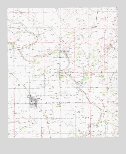
Loving, NM USGS Topographic Map
Click on map above to begin viewing in our Map Viewer.

This topographic map contains these locations and features:
Feature Name Type Latitude Longitude GNIS ID View Map
Bushy KnobSummitN32.3562°W104.0263°886976View Map
Cass DrawValleyN32.3351°W104.1111°887264View Map
Culebra BluffCliffN32.3276°W104.0574°888147View Map
Dickson FarmLocaleN32.3629°W104.1027°888381View Map
First Assembly of God ChurchChurchN32.2862°W104.0958°921249View Map
First Baptist ChurchChurchN32.2862°W104.0958°920986View Map
Flotation PlantMineN32.2835°W104.0977°915674View Map
Goodnight-Loving Trail Historical MarkerParkN32.2862°W104.0958°932359View Map
Gyp BendBendN32.2635°W104.0974°889670View Map
Harroun DamDamN32.3187°W104.0583°889804View Map
Harroun DitchCanalN32.3032°W104.0322°889805View Map
Harroun Diversion DamDamN32.3181°W104.0577°923948View Map
Harroun SchoolSchoolN32.2523°W104.0222°889806View Map
Herradura BendBendN32.3312°W104.1102°889923View Map
LovingPopulated PlaceN32.2862°W104.0958°899740View Map
Loving Elementary SchoolSchoolN32.2862°W104.0958°933901View Map
Loving Health ClinicHospitalN32.2862°W104.0958°901320View Map
Loving High SchoolSchoolN32.2862°W104.0958°901376View Map
Loving Middle SchoolSchoolN32.2862°W104.0958°901377View Map
Loving Post OfficePost OfficeN32.2850°W104.0961°938514View Map
Loving Village Police DepartmentBuildingN32.2856°W104.0967°2722534View Map
Loving Volunteer Fire Department and Emergency Medical ServicesBuildingN32.2873°W104.0975°2657610View Map
Loving Weather StationLocaleN32.2862°W104.0958°931874View Map
Lovings Bend ParkParkN32.2862°W104.0958°932219View Map
Potash Bullwheel Historic SiteLocaleN32.2862°W104.0958°934478View Map
Scoggin FlatFlatN32.2776°W104.0127°894664View Map
Southern CanalCanalN32.2673°W104.1024°895202View Map
Tempe Costa ChurchChurchN32.2990°W104.0130°895579View Map
United States Potash Company RefineryLocaleN32.3129°W104.0310°929081View Map
Village of LovingCivilN32.2866°W104.0970°2413569View Map

Note: Coordinates in the location and feature list above are referenced to NAD83 datum.


Copyright (C) 2008-2024 Ryan Niemi / Sunset Dynamics ... All Rights Reserved