TopoQuest Logo
Do you find TopoQuest useful?
Help keep TopoQuest running and adding new maps/features by donating!
Bitcoin:  19c7KJd3qBynnjoSw5npx9KScwjBe4ifkT
Litecoin:  LXs6TkuXGGXo1vDsWCkWVdjQX94eUKd6ui
Home View Maps Find Maps Find Places Resources & Links


Longville, Minnesota Topographic Map

USGS Map Title: Longville, MN
USGS Map MRC: 46094H2
DRG (GeoTIFF) Download: o46094h2.tif


Neighboring USGS Topographic Map Quads:


  Woman Lake, MN  
46094H3
 

  Longville, MN  
46094H2
 

  Laura Lake, MN  
46094H1
 

  Lake Ada, MN  
46094G3
 

  Stewart Lake, MN  
46094G2
 

  Mitchell Lake, MN  
46094G1


Map MRC Location:

N47°
W95°
N47°
W94°
H8 H7 H6 H5 H4 H3 H2 H1
G8 G7 G6 G5 G4 G3 G2 G1
F8 F7 F6 F5 F4 F3 F2 F1
E8 E7 E6 E5 E4 E3 E2 E1
D8 D7 D6 D5 D4 D3 D2 D1
C8 C7 C6 C5 C4 C3 C2 C1
B8 B7 B6 B5 B4 B3 B2 B1
A8 A7 A6 A5 A4 A3 A2 A1
N46°
W95°
N46°
W94°

Longville, MN USGS 1:24K Topographic Map Preview:
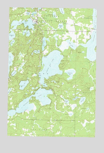
Longville, MN USGS Topographic Map
Click on map above to begin viewing in our Map Viewer.

This topographic map contains these locations and features:
Feature Name Type Latitude Longitude GNIS ID View Map
Blueberry LakeLakeN46.9224°W94.1319°655453View Map
Brackett LakeLakeN46.9099°W94.1669°655508View Map
Bullhead LakeLakeN46.9930°W94.1857°655558View Map
Camp LakeLakeN46.9110°W94.1438°655611View Map
Camp OlsonLocaleN46.9541°W94.1961°655616View Map
Charles LakeLakeN46.9125°W94.1538°655696View Map
City of LongvilleCivilN46.9876°W94.2121°2395761View Map
Cooper LakeLakeN46.9656°W94.1991°655802View Map
Craig LakeLakeN46.9953°W94.2146°655848View Map
Crooked LakeLakeN46.9290°W94.1847°655880View Map
Deer Trail Resort and CampgroundLocaleN46.9978°W94.2028°2094045View Map
Echo LakeLakeN46.9575°W94.1439°656111View Map
Gijik LakeLakeN46.9984°W94.1753°656376View Map
Girl LakeLakeN46.9858°W94.2310°656380View Map
Girl Lake Seaplane BaseAirportN46.9819°W94.2258°660262View Map
Heffron LakeLakeN46.9360°W94.2423°656565View Map
Hunter LakeLakeN46.9251°W94.2282°656681View Map
InguadonaPopulated PlaceN46.9833°W94.1302°659093View Map
Inguadona LakeLakeN46.9725°W94.1301°656703View Map
Inguadona Post Office (historical)Post OfficeN46.9833°W94.1300°2071375View Map
Jack LakeLakeN46.9752°W94.2250°656748View Map
Little Boy LakeLakeN46.9433°W94.1899°657038View Map
Little Boy Resort and CampgroundLocaleN46.9231°W94.1944°2094044View Map
LongvillePopulated PlaceN46.9863°W94.2114°657204View Map
Longville Bible ChurchChurchN46.9881°W94.2094°2071130View Map
Longville CampgroundLocaleN46.9864°W94.2111°2094038View Map
Longville City HallBuildingN46.9889°W94.2097°2094042View Map
Longville Community ChurchChurchN46.9858°W94.2083°2071131View Map
Longville Elementary SchoolSchoolN46.9853°W94.2092°2094043View Map
Longville Lakes ClinicHospitalN46.9867°W94.2144°2094041View Map
Longville Lookout TowerTowerN46.9733°W94.2064°659881View Map
Longville Municipal AirportAirportN46.9913°W94.2080°660261View Map
Longville Police DepartmentBuildingN46.9926°W94.2096°2758628View Map
Longville Post OfficePost OfficeN46.9866°W94.2121°2094039View Map
Longville Volunteer Fire DepartmentBuildingN46.9904°W94.2178°2666441View Map
Margaret Welch Memorial LibraryBuildingN46.9872°W94.2100°2094040View Map
McCarthey LakeLakeN46.9361°W94.1619°657351View Map
Nellie LakeLakeN46.9942°W94.2234°657579View Map
North Memorial Ambulance Service LongvilleBuildingN46.9913°W94.2095°2721315View Map
Rice LakeLakeN46.9640°W94.1645°658027View Map
Ridgewood Golf CourseLocaleN46.9764°W94.1472°2094046View Map
Riverside CemeteryCemeteryN46.9831°W94.2061°2071077View Map
Saint Edwards Catholic ChurchChurchN46.9844°W94.2106°2071129View Map
Salem Lutheran ChurchChurchN46.9864°W94.2111°2071132View Map
Shurd LakesLakeN46.9573°W94.2098°658256View Map
Spring CreekStreamN46.9022°W94.2144°658401View Map
Swede LakeLakeN46.9656°W94.2451°658577View Map
Tamarack LakeLakeN46.9822°W94.1766°658604View Map
Thirtysix LakeLakeN46.8971°W94.1600°658664View Map
Township of WabedoCivilN46.9348°W94.2161°665885View Map
WabedoPopulated PlaceN46.9205°W94.1880°658863View Map
Wabedo CemeteryCemeteryN46.8911°W94.2150°658864View Map
Wabedo CreekStreamN46.9169°W94.1880°658865View Map
Wabedo LakeLakeN46.9029°W94.2194°658866View Map
Wabedo Post Office (historical)Post OfficeN46.9206°W94.1878°2071384View Map
Woodcamp LakeLakeN46.9025°W94.1361°659067View Map

Note: Coordinates in the location and feature list above are referenced to NAD83 datum.


Copyright (C) 2008-2024 Ryan Niemi / Sunset Dynamics ... All Rights Reserved