TopoQuest Logo
Do you find TopoQuest useful?
Help keep TopoQuest running and adding new maps/features by donating!
Bitcoin:  19c7KJd3qBynnjoSw5npx9KScwjBe4ifkT
Litecoin:  LXs6TkuXGGXo1vDsWCkWVdjQX94eUKd6ui
Home View Maps Find Maps Find Places Resources & Links


Longton, Kansas Topographic Map

USGS Map Title: Longton, KS
USGS Map MRC: 37096D1
DRG (GeoTIFF) Download: o37096d1.tif


Neighboring USGS Topographic Map Quads:


  Severy South, KS  
37096E2
 

  Fall River, KS  
37096E1
 

  New Albany, KS  
37095E8
 

  Longton NW, KS  
37096D2
 

  Longton, KS  
37096D1
 

  Buxton, KS  
37095D8
 

  Elk Falls, KS  
37096C2
 

  Oak Valley, KS  
37096C1
 

  Elk City, KS  
37095C8


Map MRC Location:

N38°
W97°
N38°
W96°
H8 H7 H6 H5 H4 H3 H2 H1
G8 G7 G6 G5 G4 G3 G2 G1
F8 F7 F6 F5 F4 F3 F2 F1
E8 E7 E6 E5 E4 E3 E2 E1
D8 D7 D6 D5 D4 D3 D2 D1
C8 C7 C6 C5 C4 C3 C2 C1
B8 B7 B6 B5 B4 B3 B2 B1
A8 A7 A6 A5 A4 A3 A2 A1
N37°
W97°
N37°
W96°

Longton, KS USGS 1:24K Topographic Map Preview:
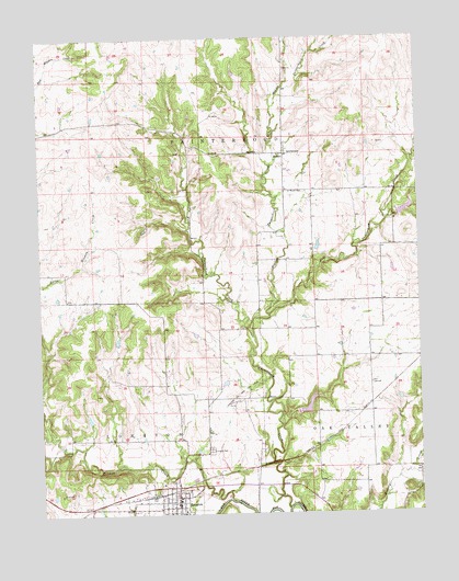
Longton, KS USGS Topographic Map
Click on map above to begin viewing in our Map Viewer.

This topographic map contains these locations and features:
Feature Name Type Latitude Longitude GNIS ID View Map
BusbyPopulated PlaceN37.4695°W96.0444°484492View Map
Busby CemeteryCemeteryN37.4595°W96.0424°469976View Map
Christian Community ChurchChurchN37.3838°W96.0804°2688852View Map
City of LongtonCivilN37.3777°W96.0823°2395760View Map
East Painterhood CreekStreamN37.4217°W96.0553°469979View Map
Elk County Rural Fire District Longton Fire DepartmentBuildingN37.3778°W96.0810°2111285View Map
Elk Valley Elementary SchoolSchoolN37.3751°W96.0796°481071View Map
Elk Valley High SchoolSchoolN37.3754°W96.0789°481070View Map
First Baptist ChurchChurchN37.3790°W96.0811°2688963View Map
Hitchen CreekStreamN37.3792°W96.0636°469993View Map
LongtonPopulated PlaceN37.3778°W96.0808°469856View Map
Longton CemeteryCemeteryN37.3921°W96.0698°469971View Map
Longton City HallBuildingN37.3776°W96.0810°2693359View Map
Longton Fire DepartmentBuildingN37.3774°W96.0811°2111568View Map
Longton Oil and Gas FieldOilfieldN37.4067°W96.0594°469972View Map
Longton Public LibraryBuildingN37.3771°W96.0810°2694658View Map
Longton Sewer Treatment PlantLocaleN37.3846°W96.0755°2692083View Map
Longton United Methodist ChurchChurchN37.3784°W96.0824°2689477View Map
Mid Painterhood CreekStreamN37.4273°W96.0500°469974View Map
Ohio TownhallBuildingN37.4089°W96.0164°469973View Map
Painterhood CreekStreamN37.3764°W96.0433°469977View Map
Rancho (historical)LocaleN37.4709°W96.0008°482183View Map
Township of PainterhoodCivilN37.4742°W96.0532°469987View Map
West Painterhood CreekStreamN37.4217°W96.0553°469978View Map

Note: Coordinates in the location and feature list above are referenced to NAD83 datum.


Copyright (C) 2008-2024 Ryan Niemi / Sunset Dynamics ... All Rights Reserved