TopoQuest Logo
Do you find TopoQuest useful?
Help keep TopoQuest running and adding new maps/features by donating!
Bitcoin:  19c7KJd3qBynnjoSw5npx9KScwjBe4ifkT
Litecoin:  LXs6TkuXGGXo1vDsWCkWVdjQX94eUKd6ui
Home View Maps Find Maps Find Places Resources & Links


Longs Peak, Colorado Topographic Map

USGS Map Title: Longs Peak, CO
USGS Map MRC: 40105C5
DRG (GeoTIFF) Download: o40105c5.tif


Neighboring USGS Topographic Map Quads:


  Trail Ridge, CO  
40105D6
 

  Estes Park, CO  
40105D5
 

  Glen Haven, CO  
40105D4
 

  McHenrys Peak, CO  
40105C6
 

  Longs Peak, CO  
40105C5
 

  Panorama Peak, CO  
40105C4
 

  Isolation Peak, CO  
40105B6
 

  Allenspark, CO  
40105B5
 

  Raymond, CO  
40105B4


Map MRC Location:

N41°
W106°
N41°
W105°
H8 H7 H6 H5 H4 H3 H2 H1
G8 G7 G6 G5 G4 G3 G2 G1
F8 F7 F6 F5 F4 F3 F2 F1
E8 E7 E6 E5 E4 E3 E2 E1
D8 D7 D6 D5 D4 D3 D2 D1
C8 C7 C6 C5 C4 C3 C2 C1
B8 B7 B6 B5 B4 B3 B2 B1
A8 A7 A6 A5 A4 A3 A2 A1
N40°
W106°
N40°
W105°

Longs Peak, CO USGS 1:24K Topographic Map Preview:
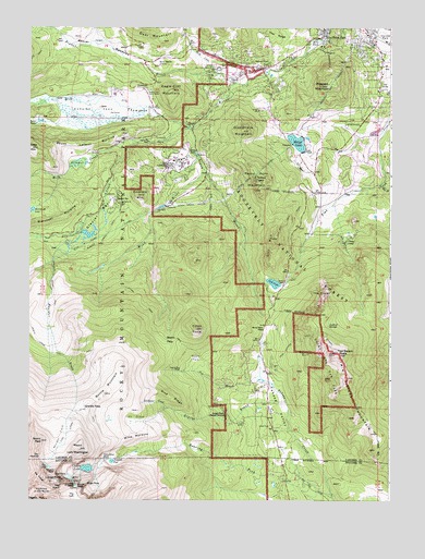
Longs Peak, CO USGS Topographic Map
Click on map above to begin viewing in our Map Viewer.

This topographic map contains these locations and features:
Feature Name Type Latitude Longitude GNIS ID View Map
Agnes Vaille Memorial ShelterParkN40.2607°W105.6211°2514188View Map
Alpine BrookStreamN40.2758°W105.5361°177946View Map
Aspen BrookStreamN40.3489°W105.5686°177907View Map
Aspen Creek SiphonCanalN40.3283°W105.5672°177908View Map
Battle MountainSummitN40.2753°W105.6048°177944View Map
Beaver BrookStreamN40.3622°W105.5464°177617View Map
Beaver MeadowsFlatN40.3708°W105.6006°177919View Map
Beaver Meadows EntranceLocaleN40.3658°W105.5811°177918View Map
Beaver PointPopulated PlaceN40.3644°W105.5444°177906View Map
Boulder BrookStreamN40.3230°W105.6069°177945View Map
Boulder Brook TrailTrailN40.3055°W105.6172°177909View Map
Boulder FieldFlatN40.2667°W105.6139°196611View Map
Buck CreekStreamN40.3630°W105.5611°177568View Map
Butterfly BurnAreaN40.2889°W105.5297°177953View Map
Cabin RockPillarN40.2750°W105.5311°196580View Map
Chasm LakeLakeN40.2584°W105.6048°204980View Map
Chasm ViewCliffN40.2575°W105.6158°177933View Map
Cheley CampLocaleN40.3180°W105.5164°177898View Map
Cleave - Griffith CemeteryCemeteryN40.3603°W105.5544°2036946View Map
Columbine FallsFallsN40.2608°W105.5992°177940View Map
Dorsey LakeReservoirN40.3419°W105.5681°177910View Map
Eagle Cliff MountainSummitN40.3584°W105.5758°177917View Map
East FaceCliffN40.2567°W105.6156°177931View Map
East Fork Fish CreekStreamN40.3342°W105.5028°177921View Map
East Gorge CanyonValleyN40.2555°W105.5363°196517View Map
East Longs Peak TrailTrailN40.2722°W105.6006°177938View Map
East PortalDamN40.3269°W105.5806°177900View Map
Edwin Bradt GraveCemeteryN40.3414°W105.5889°2036979View Map
Emerald MountainSummitN40.3307°W105.5872°204977View Map
Estes ConeSummitN40.2953°W105.5672°204983View Map
Estes Park Center/YMCA of the RockiesLocaleN40.3403°W105.5742°177911View Map
Estes Park Medical CenterHospitalN40.3715°W105.5152°2695610View Map
Estes Park Medical Center AmbulanceBuildingN40.3713°W105.5151°2716974View Map
Estes Park Post OfficePost OfficeN40.3746°W105.5230°2750924View Map
Estes PitMineN40.3569°W105.5247°1763869View Map
Estes Valley Fire Protection District Station 2BuildingN40.3630°W105.5579°2667128View Map
Eugenia MineMineN40.2842°W105.5731°177949View Map
Fawn CreekStreamN40.2515°W105.5199°204645View Map
Game PassGapN40.2861°W105.5283°196572View Map
Gianttrack MountainSummitN40.3477°W105.5514°204975View Map
Glacier BasinBasinN40.3264°W105.6006°204973View Map
Glacier Basin CampgroundLocaleN40.3278°W105.5944°197716View Map
Glacier CreekStreamN40.3489°W105.5711°177896View Map
Glacier RidgeRidgeN40.2532°W105.6082°177929View Map
Granite PassGapN40.2744°W105.6056°177943View Map
Harris Wellcome GraveCemeteryN40.3341°W105.5614°2036922View Map
Herbert Richards GraveCemeteryN40.3239°W105.6067°2036903View Map
Hollowell ParkFlatN40.3389°W105.6061°177913View Map
Hupp Family CemeteryCemeteryN40.3719°W105.5947°2036956View Map
Inn BrookStreamN40.2828°W105.5450°204982View Map
Jims GroveAreaN40.2722°W105.5881°177942View Map
Joe Mills PondReservoirN40.3714°W105.5247°177905View Map
Keyboard of the WindsPillarN40.2528°W105.6239°177924View Map
KSIR-AM (Estes Park)TowerN40.3375°W105.5272°204871View Map
Lambs SlideCliffN40.2539°W105.6092°177930View Map
Larkspur CreekStreamN40.2742°W105.5767°177947View Map
Lily LakeReservoirN40.3073°W105.5403°204985View Map
Lily MountainSummitN40.3190°W105.5412°204986View Map
Lily Mountain TrailTrailN40.3222°W105.5406°177899View Map
Long Peak TrailTrailN40.2917°W105.6217°202509View Map
Longs PeakSummitN40.2549°W105.6162°204979View Map
Longs Peak CampgroundLocaleN40.2747°W105.5586°197715View Map
Longs Peak Ranger StationLocaleN40.2725°W105.5572°177950View Map
Lookout SpringsSpringN40.2961°W105.5242°177959View Map
Marys LakeReservoirN40.3461°W105.5308°177903View Map
Marys Lake Dike Number 1 DamDamN40.3433°W105.5256°200668View Map
Marys Lake Dike Number 2 DamDamN40.3433°W105.5256°200670View Map
Mill CreekStreamN40.3447°W105.5881°177897View Map
Mills GlacierGlacierN40.2557°W105.6106°177934View Map
Mills MoraineRidgeN40.2645°W105.5993°177941View Map
Moore ParkFlatN40.2875°W105.5672°177954View Map
Moraine ParkFlatN40.3533°W105.6028°177915View Map
Moraine Park CampgroundLocaleN40.3583°W105.6006°197708View Map
Moraine Park Visitor CenterLocaleN40.3586°W105.5833°177916View Map
Moss BrookStreamN40.2833°W105.5450°1675524View Map
Mount Lady WashingtonSummitN40.2635°W105.6072°177939View Map
Peacock PoolLakeN40.2603°W105.5963°177936View Map
Pine RidgeRidgeN40.2789°W105.5863°177948View Map
Prospect MountainSummitN40.3602°W105.5204°204976View Map
Prospect Mountain TunnelTunnelN40.3611°W105.5200°177904View Map
Rams Horn MountainSummitN40.3322°W105.5451°204974View Map
Rams Horn TunnelTunnelN40.3375°W105.5450°177902View Map
Ransom S Kendall GraveCemeteryN40.3730°W105.6011°2036958View Map
Rocky Mountain National Park Administration BuildingParkN40.3663°W105.5610°2559511View Map
Saint Francis of Assisi Anglican Church CemeteryCemeteryN40.3264°W105.5025°2036907View Map
Shelter HouseLocaleN40.2587°W105.6011°177935View Map
Ships ProwCliffN40.2539°W105.6053°177928View Map
South Lateral MoraineRidgeN40.3444°W105.6175°177914View Map
Sprague LakeLakeN40.3202°W105.6048°1802559View Map
Steep MountainSummitN40.3430°W105.6242°204972View Map
Storm PassGapN40.2928°W105.5742°177955View Map
Storm Pass TrailTrailN40.3005°W105.5839°177958View Map
Storm PeakSummitN40.2655°W105.6205°204981View Map
Teddys TeethPillarN40.3347°W105.5467°177901View Map
The CragsPillarN40.3050°W105.5272°177960View Map
The CragsCliffN40.3028°W105.5214°196571View Map
The DoveGlacierN40.2589°W105.6181°177932View Map
The KeyholeGapN40.2608°W105.6211°177937View Map
The LoftBasinN40.2511°W105.6089°177927View Map
The NotchGapN40.2539°W105.6056°177926View Map
The TroughValleyN40.2578°W105.6226°177925View Map
Town of Estes ParkCivilN40.3499°W105.5119°2412603View Map
Tuxedo ParkFlatN40.3455°W105.5797°177912View Map
Tuxedo Park CemeteryCemeteryN40.3453°W105.5811°2036917View Map
Twin Sister TrailTrailN40.2928°W105.5311°177956View Map
Twin Sisters MountainSummitN40.2855°W105.5175°177951View Map
Twin Sisters PeaksSummitN40.2889°W105.5183°177952View Map
Wind RiverStreamN40.3375°W105.5650°177957View Map
Wind River PassGapN40.2956°W105.5433°204984View Map
Wind River TrailTrailN40.3489°W105.5686°2677501View Map

Note: Coordinates in the location and feature list above are referenced to NAD83 datum.


Copyright (C) 2008-2024 Ryan Niemi / Sunset Dynamics ... All Rights Reserved