TopoQuest Logo
Do you find TopoQuest useful?
Help keep TopoQuest running and adding new maps/features by donating!
Bitcoin:  19c7KJd3qBynnjoSw5npx9KScwjBe4ifkT
Litecoin:  LXs6TkuXGGXo1vDsWCkWVdjQX94eUKd6ui
Home View Maps Find Maps Find Places Resources & Links


Littleton, North Carolina Topographic Map

USGS Map Title: Littleton, NC
USGS Map MRC: 36077D8
DRG (GeoTIFF) Download: o36077d8.tif


Neighboring USGS Topographic Map Quads:


  South Hill SE, VA  
36078E1
 

  Gasburg, VA  
36077E8
 

  Valentines, VA  
36077E7
 

  Macon, NC  
36078D1
 

  Littleton, NC  
36077D8
 

  Thelma, NC  
36077D7
 

  Inez, NC  
36078C1
 

  Hollister, NC  
36077C8
 

  Aurelian Springs, NC  
36077C7


Map MRC Location:

N37°
W78°
N37°
W77°
H8 H7 H6 H5 H4 H3 H2 H1
G8 G7 G6 G5 G4 G3 G2 G1
F8 F7 F6 F5 F4 F3 F2 F1
E8 E7 E6 E5 E4 E3 E2 E1
D8 D7 D6 D5 D4 D3 D2 D1
C8 C7 C6 C5 C4 C3 C2 C1
B8 B7 B6 B5 B4 B3 B2 B1
A8 A7 A6 A5 A4 A3 A2 A1
N36°
W78°
N36°
W77°

Littleton, NC USGS 1:24K Topographic Map Preview:
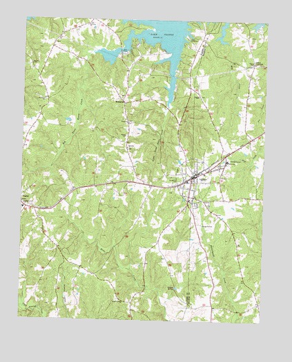
Littleton, NC USGS Topographic Map
Click on map above to begin viewing in our Map Viewer.

This topographic map contains these locations and features:
Feature Name Type Latitude Longitude GNIS ID View Map
Ashley Grove ChurchChurchN36.4226°W77.9986°980334View Map
Bethlehem ChurchChurchN36.4982°W77.9669°981233View Map
Big Stone House CreekStreamN36.4871°W77.9614°981459View Map
Camp Willow RunLocaleN36.4926°W77.9158°982562View Map
Cooleys CrossroadsPopulated PlaceN36.4826°W77.8811°1006167View Map
EnterprisePopulated PlaceN36.4657°W77.9483°984813View Map
Enterprise ChurchChurchN36.4471°W77.9461°984814View Map
Gruvers Memorial ChurchChurchN36.3829°W77.9461°986184View Map
Halifax Emergency Medical Services Station 1 - Warren County Rescue SquadBuildingN36.4619°W77.9471°2720706View Map
Little Stone House CreekStreamN36.4646°W77.9255°988779View Map
LittletonPopulated PlaceN36.4346°W77.9119°988811View Map
Littleton Police DepartmentBuildingN36.4350°W77.9106°2769677View Map
Littleton Post OfficePost OfficeN36.4338°W77.9117°2774017View Map
Littleton Volunteer Fire DepartmentBuildingN36.4366°W77.9071°2638355View Map
Longbridge Volunteer Fire DepartmentBuildingN36.4984°W77.9651°2639370View Map
Macons GraveCemeteryN36.4807°W77.9947°989218View Map
Mciver SchoolSchoolN36.4415°W77.8939°989659View Map
Mill CreekStreamN36.4910°W77.8944°989938View Map
Olive Grove ChurchChurchN36.4663°W77.9889°991641View Map
Panacea SpringsSpringN36.3890°W77.9197°991816View Map
Pleasant Zion ChurchChurchN36.4574°W77.9455°992586View Map
Roanoke ChapelChurchN36.4674°W77.9111°993411View Map
Saint Annas ChurchChurchN36.4349°W77.8972°993869View Map
Sunset Hill CemeteryCemeteryN36.4326°W77.9189°995709View Map
Town of LittletonCivilN36.4343°W77.9110°2406026View Map
Township of JudkinsCivilN36.3883°W77.9987°1027281View Map
Township of RiverCivilN36.4697°W77.9638°1027283View Map
Vaughan Elementary SchoolSchoolN36.4215°W77.9989°1007021View Map
Weaver ChapelChurchN36.4818°W77.8817°996904View Map

Note: Coordinates in the location and feature list above are referenced to NAD83 datum.


Copyright (C) 2008-2024 Ryan Niemi / Sunset Dynamics ... All Rights Reserved