TopoQuest Logo
Do you find TopoQuest useful?
Help keep TopoQuest running and adding new maps/features by donating!
Bitcoin:  19c7KJd3qBynnjoSw5npx9KScwjBe4ifkT
Litecoin:  LXs6TkuXGGXo1vDsWCkWVdjQX94eUKd6ui
Home View Maps Find Maps Find Places Resources & Links


Little Switzerland, North Carolina Topographic Map

USGS Map Title: Little Switzerland, NC
USGS Map MRC: 35082G1
DRG (GeoTIFF) Download: o35082g1.tif


Neighboring USGS Topographic Map Quads:


  Micaville, NC  
35082H2
 

  Spruce Pine, NC  
35082H1
 

  Linville Falls, NC  
35081H8
 

  Celo, NC  
35082G2
 

  Little Switzerland, NC  
35082G1
 

  Ashford, NC  
35081G8
 

  Old Fort, NC  
35082F2
 

  Marion West, NC  
35082F1
 

  Marion East, NC  
35081F8


Map MRC Location:

N36°
W83°
N36°
W82°
H8 H7 H6 H5 H4 H3 H2 H1
G8 G7 G6 G5 G4 G3 G2 G1
F8 F7 F6 F5 F4 F3 F2 F1
E8 E7 E6 E5 E4 E3 E2 E1
D8 D7 D6 D5 D4 D3 D2 D1
C8 C7 C6 C5 C4 C3 C2 C1
B8 B7 B6 B5 B4 B3 B2 B1
A8 A7 A6 A5 A4 A3 A2 A1
N35°
W83°
N35°
W82°

Little Switzerland, NC USGS 1:24K Topographic Map Preview:
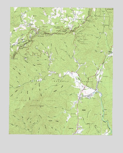
Little Switzerland, NC USGS Topographic Map
Click on map above to begin viewing in our Map Viewer.

This topographic map contains these locations and features:
Feature Name Type Latitude Longitude GNIS ID View Map
Armstrong CreekStreamN35.7937°W82.0193°1008770View Map
Bad ForkStreamN35.7993°W82.1071°1008841View Map
Bald Mountain TrailTrailN35.7618°W82.0229°1008878View Map
Bartlett CreekStreamN35.8235°W82.0873°1008948View Map
Bearwallow GapGapN35.8415°W82.1015°1009053View Map
Betsy CreekRidgeN35.7640°W82.0823°1009230View Map
Biddix CemeteryCemeteryN35.8718°W82.0140°1009247View Map
Bird Ridge TunnelTunnelN35.8673°W82.0173°1009422View Map
Black Mountain ChurchChurchN35.8396°W82.1157°1009443View Map
Blue Ridge Gemstone Mine and CampgroundLocaleN35.8560°W82.1098°1017884View Map
Briery MountainSummitN35.8601°W82.0571°1019301View Map
Buchanan CreekStreamN35.8273°W82.0793°1009730View Map
Buckner DamDamN35.8401°W82.1098°1017305View Map
Buckner LakeReservoirN35.8408°W82.1100°1017304View Map
Burnett CemeteryCemeteryN35.8562°W82.1034°1009835View Map
Caney BranchStreamN35.8068°W82.0607°1010015View Map
Chestnut Grove ChurchChurchN35.8573°W82.1021°1010251View Map
Chestnut RidgeRidgeN35.8271°W82.0662°1010267View Map
Collis BranchStreamN35.8601°W82.1215°1010418View Map
Collis CemeteryCemeteryN35.8629°W82.1115°1010419View Map
Conley BranchStreamN35.8076°W82.0198°1010436View Map
Conley Memorial ChurchChurchN35.8076°W82.0121°1010440View Map
Cow CreekStreamN35.7960°W82.1209°1010519View Map
Cox CreekStreamN35.8046°W82.0396°1010538View Map
Cox Creek ChurchChurchN35.8176°W82.0407°1010539View Map
Deer Lick BranchStreamN35.8354°W82.1240°1010767View Map
Deer Lick GapGapN35.8246°W82.1212°1010768View Map
Deerstand CreekStreamN35.7529°W82.0976°1010774View Map
Dula KnobSummitN35.8668°W82.0554°1020046View Map
Firescald CreekStreamN35.7590°W82.0976°1011220View Map
First Rocky TunnelTunnelN35.8704°W82.0071°1011225View Map
First Washburn TunnelTunnelN35.8498°W82.0437°1011226View Map
Gillespie GapGapN35.8526°W82.0509°1011494View Map
GlenlaurelPopulated PlaceN35.8360°W82.1129°1020448View Map
Gooch GapGapN35.8346°W82.1137°1010476View Map
Grassy Creek FallsFallsN35.8562°W82.0853°985960View Map
Grassy KnobSummitN35.7565°W82.0529°1020512View Map
Grassy MountainSummitN35.8501°W82.0996°1018005View Map
Graveyard MountainSummitN35.7743°W82.0312°1020529View Map
Green Mountain CemeteryCemeteryN35.7704°W82.0504°1011705View Map
Harris CreekStreamN35.7723°W82.0559°1011874View Map
Hensley RidgeRidgeN35.7635°W82.0709°1011978View Map
Hickory Bottom BranchStreamN35.7968°W82.0279°1011998View Map
Hicks ChapelChurchN35.7573°W82.0407°1012028View Map
Hollifield CemeteryCemeteryN35.8282°W82.0776°1012132View Map
Laurel LakeReservoirN35.8663°W82.1104°1012747View Map
Limekiln CreekStreamN35.7932°W82.0190°1012873View Map
Little SwitzerlandPopulated PlaceN35.8493°W82.0904°1021241View Map
Little Switzerland Post OfficePost OfficeN35.8491°W82.0940°2766614View Map
Little Switzerland TunnelTunnelN35.8515°W82.0859°1013034View Map
Locust KnobSummitN35.8187°W82.0923°1021258View Map
Long BranchStreamN35.8032°W82.0862°1013126View Map
Lonon BranchStreamN35.8501°W82.0112°1013186View Map
Lonon CemeteryCemeteryN35.8368°W82.0204°1013187View Map
Lower Bridle TunnelTunnelN35.8557°W82.0332°1013237View Map
Lower Pine TunnelTunnelN35.8646°W82.0223°1013244View Map
Lynn GapGapN35.8493°W82.0729°1013272View Map
Mace BranchStreamN35.8310°W82.0557°1013275View Map
Martin BranchStreamN35.8251°W82.0090°1013335View Map
McCall GapGapN35.8579°W82.1029°1013397View Map
Muddy BranchStreamN35.8037°W82.0632°1013820View Map
Museum of North Carolina MineralsBuildingN35.8576°W82.0526°1018011View Map
North Carolina State Fish HatcheryLocaleN35.7940°W82.1240°1018006View Map
North Cove ChurchChurchN35.8282°W82.0009°1013984View Map
North Cove CrossingPopulated PlaceN35.8315°W82.0007°1013985View Map
North Fork Grassy CreekStreamN35.8618°W82.0676°1014000View Map
ODear CreekStreamN35.8232°W82.0771°1014045View Map
Osborne KnobSummitN35.8382°W82.1068°1848184View Map
Osborne KnobPopulated PlaceN35.8354°W82.1096°1021758View Map
Parkway Fire and Rescue Station 3BuildingN35.8561°W82.0997°2639385View Map
Pepper CreekStreamN35.8296°W82.0059°1014332View Map
Pepper Creek ChurchChurchN35.8504°W82.0115°1014333View Map
Pepper Creek ChurchChurchN35.8587°W82.0121°1014334View Map
Pompey RidgeRidgeN35.8215°W82.1009°1018090View Map
Pups BranchStreamN35.7979°W82.1112°1014674View Map
Pups RidgeRidgeN35.8129°W82.1198°1022109View Map
Quinn Knob TunnelTunnelN35.8421°W82.0426°1014692View Map
Rag CreekStreamN35.8262°W82.0484°1014711View Map
Rattlesnake BranchStreamN35.7629°W82.1082°1014750View Map
Reddick BranchStreamN35.8648°W82.0468°1022203View Map
Rich KnobSummitN35.8662°W82.0985°1022257View Map
Roaring ForkStreamN35.8023°W82.0912°1014940View Map
Rocky SidingLocaleN35.8579°W82.0051°1015057View Map
Roses CreekStreamN35.8021°W82.0957°1015091View Map
Rough RidgeRidgeN35.7879°W82.1023°1015104View Map
Sandy GapGapN35.8490°W82.0823°1015240View Map
Second Rocky TunnelTunnelN35.8668°W82.0048°1015347View Map
Second Washburn TunnelTunnelN35.8468°W82.0446°1015348View Map
SevierPopulated PlaceN35.8026°W82.0168°1022552View Map
Sheehan CreekStreamN35.7557°W82.1054°1015398View Map
Silver KnobSummitN35.7862°W82.0748°1023574View Map
Slim CreekStreamN35.7579°W82.0984°1015588View Map
Snipes TunnelTunnelN35.8446°W82.0357°1015638View Map
Snow Hill CemeteryCemeteryN35.8115°W82.0862°1015640View Map
Sol RidgeRidgeN35.8732°W82.0871°1015671View Map
South Fork Roses CreekStreamN35.8121°W82.1059°1015694View Map
Speedy TunnelTunnelN35.8615°W82.0279°1015722View Map
Stony KnobSummitN35.8518°W82.0634°1022809View Map
Strawberry RidgePopulated PlaceN35.8435°W82.1112°1022816View Map
Swafford GapGapN35.8623°W82.0340°1015968View Map
Sycamore BranchStreamN35.8240°W82.0765°1015999View Map
The LoopLocaleN35.8421°W82.0426°1016090View Map
Third Washburn TunnelTunnelN35.8398°W82.0371°1016101View Map
Three Mile CreekStreamN35.8101°W82.0743°1016135View Map
Township of North CoveCivilN35.8351°W82.0216°1026899View Map
Turkey CoveValleyN35.7933°W82.0202°1016270View Map
Turkey Cove ChurchChurchN35.8223°W82.0757°1016271View Map
Upper Bridle TunnelTunnelN35.8562°W82.0354°1016328View Map
Upper Pine TunnelTunnelN35.8662°W82.0246°996557View Map
Van Noy BranchStreamN35.8465°W82.0159°1016359View Map
Walnut CoveValleyN35.8493°W82.0148°1016420View Map
Washburn CemeteryCemeteryN35.8201°W82.0393°1016453View Map
Wiggins RidgeRidgeN35.7943°W82.0634°1016653View Map
WildacresPopulated PlaceN35.8243°W82.1059°1023240View Map
Wildacres TunnelTunnelN35.8296°W82.1179°1016662View Map
Witness Rock RidgeRidgeN35.7923°W82.0871°1016764View Map
WoodlawnPopulated PlaceN35.7854°W82.0404°1023314View Map
Woodlawn Work CenterLocaleN35.7685°W82.0423°1018012View Map
Woods MountainSummitN35.7782°W82.0882°1016820View Map
Woods Mountain Lookout TowerTowerN35.7782°W82.0882°1023695View Map
Yancey PondReservoirN35.7885°W82.0363°1016854View Map

Note: Coordinates in the location and feature list above are referenced to NAD83 datum.


Copyright (C) 2008-2024 Ryan Niemi / Sunset Dynamics ... All Rights Reserved