TopoQuest Logo
Do you find TopoQuest useful?
Help keep TopoQuest running and adding new maps/features by donating!
Bitcoin:  19c7KJd3qBynnjoSw5npx9KScwjBe4ifkT
Litecoin:  LXs6TkuXGGXo1vDsWCkWVdjQX94eUKd6ui
Home View Maps Find Maps Find Places Resources & Links


Little Elm, Texas Topographic Map

USGS Map Title: Little Elm, TX
USGS Map MRC: 33096B8
DRG (GeoTIFF) Download: o33096b8.tif


Neighboring USGS Topographic Map Quads:


  Green Valley, TX  
33097C1
 

  Aubrey, TX  
33096C8
 

  Celina, TX  
33096C7
 

  Denton East, TX  
33097B1
 

  Little Elm, TX  
33096B8
 

  Frisco, TX  
33096B7
 

  Lewisville West, TX  
33097A1
 

  Lewisville East, TX  
33096A8
 

  Hebron, TX  
33096A7


Map MRC Location:

N34°
W97°
N34°
W96°
H8 H7 H6 H5 H4 H3 H2 H1
G8 G7 G6 G5 G4 G3 G2 G1
F8 F7 F6 F5 F4 F3 F2 F1
E8 E7 E6 E5 E4 E3 E2 E1
D8 D7 D6 D5 D4 D3 D2 D1
C8 C7 C6 C5 C4 C3 C2 C1
B8 B7 B6 B5 B4 B3 B2 B1
A8 A7 A6 A5 A4 A3 A2 A1
N33°
W97°
N33°
W96°

Little Elm, TX USGS 1:24K Topographic Map Preview:
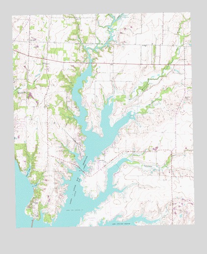
Little Elm, TX USGS Topographic Map
Click on map above to begin viewing in our Map Viewer.

This topographic map contains these locations and features:
Feature Name Type Latitude Longitude GNIS ID View Map
Aubrey Area Ambulance Station 2BuildingN33.2222°W96.9305°2655952View Map
Aubrey Fire Department Station 2BuildingN33.2221°W96.9305°2551780View Map
Camp DallasPopulated PlaceN33.1398°W96.9889°1331969View Map
Camp LucilleLocaleN33.1326°W96.9872°1331986View Map
City of Hackberry Wastewater Treatment PlantLocaleN33.1502°W96.9206°2428165View Map
City of Lakewood VillageCivilN33.1378°W96.9750°2411616View Map
City of Little ElmCivilN33.1844°W96.9292°2410843View Map
City of Oak PointCivilN33.1802°W96.9912°2411289View Map
Cottonpatch AerodromeAirportN33.1493°W96.8989°1386700View Map
Cottonwood BranchStreamN33.1640°W96.9214°1333426View Map
Cottonwood ParkParkN33.1448°W96.9458°2043457View Map
Cottonwood Park (historical)ParkN33.1437°W96.9467°2028550View Map
Cross Roads Town HallBuildingN33.2294°W96.9882°2753655View Map
Denton County Constable's Office Precinct 5BuildingN33.2294°W96.9881°2739094View Map
Doe BranchStreamN33.1807°W96.9347°1373415View Map
Doe Branch Park (historical)ParkN33.1823°W96.9436°2028437View Map
Elm Ridge ChurchChurchN33.2310°W96.9061°1335396View Map
First Pentecostal Church of FriscoChurchN33.1615°W96.8800°2018222View Map
Frisco Fire Department Station 7BuildingN33.1454°W96.8938°2766561View Map
HackberryPopulated PlaceN33.1523°W96.9178°1388577View Map
Hackberry ParkParkN33.1296°W96.9470°1373969View Map
Jefferson SloughBayN33.1576°W96.9908°1338702View Map
John House SpringsSpringN33.1751°W96.9086°1998696View Map
Lake Lewisville Recreation AreaParkN33.1287°W96.9475°2028980View Map
Lakewood VillagePopulated PlaceN33.1426°W96.9695°1388578View Map
Liberty ChurchChurchN33.2476°W96.9520°1339885View Map
Lincoln ParkPopulated PlaceN33.2221°W96.9728°1388579View Map
Little ElmPopulated PlaceN33.1626°W96.9375°1340088View Map
Little Elm CemeteryCemeteryN33.1579°W96.9250°1340090View Map
Little Elm Central Fire StationBuildingN33.1596°W96.9386°2551462View Map
Little Elm CreekStreamN33.1398°W96.9575°1374579View Map
Little Elm Intermediate SchoolSchoolN33.1562°W96.9450°2003983View Map
Little Elm ParkParkN33.1598°W96.9458°1336264View Map
Little Elm Police DepartmentBuildingN33.1587°W96.9395°2739015View Map
Little Elm Post OfficePost OfficeN33.1540°W96.9478°2731943View Map
Lloyd CemeteryCemeteryN33.2087°W96.9733°1340290View Map
Marion FieldParkN33.1518°W96.9403°2027789View Map
Mary Young ChapelChurchN33.1990°W96.8794°1341043View Map
Narrow Lake ParkParkN33.1657°W96.9595°2029689View Map
NavoPopulated PlaceN33.2207°W96.9300°1378729View Map
New Hope (historical)Populated PlaceN33.2346°W96.9886°1388194View Map
Nix SloughBayN33.1496°W96.9870°1342616View Map
Oak Grove ChurchChurchN33.2212°W96.9758°1342977View Map
Oak PointPopulated PlaceN33.1901°W96.9917°1388580View Map
Oak Point Department of Public Safety Fire ServicesBuildingN33.1912°W96.9922°2551786View Map
Oak Point Police DepartmentBuildingN33.1912°W96.9909°2739110View Map
Paloma Creek Census Designated PlaceCensusN33.2256°W96.9371°2584710View Map
Paloma Creek South Census Designated PlaceCensusN33.2101°W96.9326°2584711View Map
Panther CreekStreamN33.1815°W96.9300°1343536View Map
Pecan CreekStreamN33.2460°W96.9283°1375393View Map
Phillips DamDamN33.1301°W96.8853°1855420View Map
Phillips LakeReservoirN33.1301°W96.8853°1855421View Map
Phillips North LakeReservoirN33.1418°W96.8886°1863868View Map
Phillips North Lake DamDamN33.1418°W96.8886°1863867View Map
ProvidencePopulated PlaceN33.2334°W96.9616°2633236View Map
Providence Census Designated Place (historical)CensusN33.2320°W96.9626°2584715View Map
Running BranchStreamN33.2296°W96.9486°1375852View Map
Savannah Census Designated PlaceCensusN33.2259°W96.9079°2584739View Map
Spanish Oaks AirportAirportN33.1473°W96.9761°1387087View Map
Tannery LakeReservoirN33.2029°W96.9883°1855423View Map
Tannery Lake DamDamN33.2035°W96.9886°1855422View Map
Town of Cross RoadsCivilN33.2283°W96.9990°2412391View Map
Town of HackberryCivilN33.1501°W96.9184°2412717View Map
Town of Lincoln Park (historical)CivilN33.2240°W96.9727°2412898View Map
Town of Little Elm Water Treatment FacilityLocaleN33.1671°W96.9111°2428233View Map
Town of Providence VillageCivilN33.2329°W96.9623°2703983View Map
Zion CemeteryCemeteryN33.1985°W96.8797°1350741View Map

Note: Coordinates in the location and feature list above are referenced to NAD83 datum.


Copyright (C) 2008-2024 Ryan Niemi / Sunset Dynamics ... All Rights Reserved