TopoQuest Logo
Do you find TopoQuest useful?
Help keep TopoQuest running and adding new maps/features by donating!
Bitcoin:  19c7KJd3qBynnjoSw5npx9KScwjBe4ifkT
Litecoin:  LXs6TkuXGGXo1vDsWCkWVdjQX94eUKd6ui
Home View Maps Find Maps Find Places Resources & Links


Little Creek, Delaware Topographic Map

USGS Map Title: Little Creek, DE
USGS Map MRC: 39075B4
DRG (GeoTIFF) Download: o39075b4.tif


Neighboring USGS Topographic Map Quads:


  Smyrna, DE  
39075C5
 

  Bombay Hook Island, DE  
39075C4
 

  Ben Davis Point, NJ  
39075C3
 

  Dover, DE  
39075B5
 

  Little Creek, DE  
39075B4


  Wyoming, DE  
39075A5
 

  Frederica, DE  
39075A4
 

  Bennetts Pier, DE  
39075A3


Map MRC Location:

N40°
W76°
N40°
W75°
H8 H7 H6 H5 H4 H3 H2 H1
G8 G7 G6 G5 G4 G3 G2 G1
F8 F7 F6 F5 F4 F3 F2 F1
E8 E7 E6 E5 E4 E3 E2 E1
D8 D7 D6 D5 D4 D3 D2 D1
C8 C7 C6 C5 C4 C3 C2 C1
B8 B7 B6 B5 B4 B3 B2 B1
A8 A7 A6 A5 A4 A3 A2 A1
N39°
W76°
N39°
W75°

Little Creek, DE USGS 1:24K Topographic Map Preview:
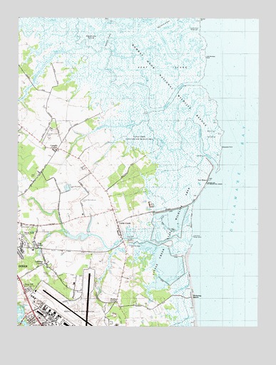
Little Creek, DE USGS Topographic Map
Click on map above to begin viewing in our Map Viewer.

This topographic map contains these locations and features:
Feature Name Type Latitude Longitude GNIS ID View Map
Bay GutGutN39.2337°W75.4455°213605View Map
Boat GutGutN39.2412°W75.4683°213687View Map
Cattail GutGutN39.1521°W75.4241°213768View Map
Cedar GutGutN39.2265°W75.4160°213775View Map
Chandelle Estates AirportAirportN39.2050°W75.4824°217224View Map
Cherbourg Round BarnParkN39.1512°W75.4566°213877View Map
Cowgills CornerPopulated PlaceN39.1959°W75.4802°216074View Map
Deepwater PointCapeN39.2009°W75.3910°213869View Map
Devers GutGutN39.2365°W75.4496°213882View Map
Donas LandingPopulated PlaceN39.2126°W75.4310°216081View Map
Dover Air Force BaseMilitaryN39.1280°W75.4655°2512167View Map
Dover Air Force BaseAirportN39.1275°W75.4714°2787267View Map
Dover Behavioral Health SystemBuildingN39.1535°W75.4843°1988748View Map
Dover DivisionCivilN39.1588°W75.4687°1935606View Map
Dover East Estates Mobile Home ParkPopulated PlaceN39.1602°W75.4975°2378913View Map
Dover East Industrial ParkLocaleN39.1510°W75.4844°2378921View Map
Doverbrook GardensPopulated PlaceN39.1376°W75.4706°2400417View Map
Drum GutGutN39.2315°W75.4424°213907View Map
Duck CreekStreamN39.2443°W75.4258°216374View Map
East West CanalCanalN39.2290°W75.4396°213921View Map
Flat GutGutN39.2293°W75.4469°213964View Map
Friends Meetinghouse CemeteryCemeteryN39.1759°W75.4668°213984View Map
Generals GreenPopulated PlaceN39.1274°W75.4921°2400416View Map
Generals GreenePopulated PlaceN39.1259°W75.4169°216278View Map
Green CreekStreamN39.2129°W75.4296°214028View Map
Herring BranchStreamN39.2129°W75.4296°214083View Map
HilldalePopulated PlaceN39.1959°W75.4816°216277View Map
Indian GutGutN39.1882°W75.4055°214139View Map
Interchange 97CrossingN39.1473°W75.4946°2400372View Map
Interchange 98CrossingN39.1659°W75.4933°2400371View Map
Jenkins DitchGutN39.1987°W75.4294°214168View Map
Joes HoleGutN39.2262°W75.4338°214171View Map
Kelly IslandIslandN39.2034°W75.3985°214185View Map
Kellys DitchGutN39.1887°W75.4155°214186View Map
Kent IslandIslandN39.2301°W75.4263°214189View Map
Kings Cliff Mobile Home ParkPopulated PlaceN39.1390°W75.4963°216642View Map
Laffertys CornerPopulated PlaceN39.1507°W75.4858°216828View Map
Leipsic RiverStreamN39.2446°W75.4030°216386View Map
Leipsic River Range LightsLocaleN39.2462°W75.4102°217765View Map
Lewis DitchGutN39.1259°W75.4180°214218View Map
Little Bombay HookCapeN39.2357°W75.3991°214229View Map
Little CreekPopulated PlaceN39.1671°W75.4483°214231View Map
Little Creek BridgeBridgeN39.1604°W75.4455°216829View Map
Little Creek HundredCivilN39.1751°W75.4580°217252View Map
Little Creek LandingPopulated PlaceN39.1609°W75.4449°216138View Map
Little Creek Methodist ChurchChurchN39.1637°W75.4460°217772View Map
Little Creek Post OfficePost OfficeN39.1669°W75.4479°2378935View Map
Little Creek Town HallBuildingN39.1669°W75.4480°2378934View Map
Little Creek United Methodist ChurchChurchN39.1639°W75.4468°2378936View Map
Little Creek Volunteer Fire CompanyBuildingN39.1647°W75.4477°2610785View Map
Little Creek Wildlife AreaParkN39.1668°W75.4246°216830View Map
Little ForkGutN39.2412°W75.4558°214233View Map
Little RiverStreamN39.1601°W75.4077°214240View Map
Little River Range LightsLocaleN39.1618°W75.4088°216466View Map
Mahon RiverStreamN39.1846°W75.3977°214265View Map
Marshall IslandIslandN39.2471°W75.4241°214272View Map
Marshtown GutGutN39.1951°W75.4269°214275View Map
MCD Business ParkLocaleN39.1547°W75.4885°2378918View Map
Moors CemeteryCemeteryN39.2317°W75.4808°214335View Map
Morgan BranchStreamN39.1637°W75.4760°214336View Map
Muddy BranchStreamN39.2387°W75.4680°214357View Map
Needhams IslandIslandN39.2412°W75.4624°214376View Map
North South CanalCanalN39.2373°W75.4308°214394View Map
Oak GrovePopulated PlaceN39.1565°W75.4894°214396View Map
Oak ShadowsPopulated PlaceN39.1840°W75.4886°2400410View Map
Octagonal School HouseParkN39.1951°W75.4769°215271View Map
Old CreekGutN39.2315°W75.4024°214409View Map
Old Marina CanalCanalN39.1401°W75.4144°215507View Map
Old Stone TavernParkN39.1626°W75.4460°215270View Map
Old Womans GutGutN39.1984°W75.4266°214417View Map
Pickering BeachBeachN39.1371°W75.4096°214448View Map
Pipe Elm BranchStreamN39.1576°W75.4485°214463View Map
Port MahonPopulated PlaceN39.1854°W75.4010°214476View Map
Postles CornerPopulated PlaceN39.1348°W75.4480°216187View Map
Ragged IslandIslandN39.2415°W75.4533°214515View Map
Shadybrook FarmsPopulated PlaceN39.1892°W75.4657°2400411View Map
Simons RiverStreamN39.2232°W75.4041°214656View Map
Tarburton PitMineN39.1792°W75.4728°2635772View Map
Taylors GutGutN39.1707°W75.4219°214724View Map
Town of Little CreekCivilN39.1662°W75.4480°2391271View Map
Tudor Industrial ParkLocaleN39.1550°W75.4974°2378914View Map
Tyn Head CourtParkN39.1546°W75.4763°214327View Map

Note: Coordinates in the location and feature list above are referenced to NAD83 datum.


Copyright (C) 2008-2024 Ryan Niemi / Sunset Dynamics ... All Rights Reserved